December 29, 2016
Wednesday, February 22, 2017
How We Located a Construction Defect in Our Roof
droneblog.com
By Paul Davis
February 21, 2017

Drip, drip, drip, the sound of water falling from the ceiling was either a welcome sound or an overwhelming distraction in our office space. I work in a coworking office in Fort Mill, SC and we had moved in to our brand-new location right before the holiday season; come January, the roof was already leaking!
Using an Unmanned Aerial Vehicle (Drone)
Wondering what might be the cause and not wanting to make a mess in the exposed rafters right before our grand opening, Matt Mulhernn with Go Unmanned came to our rescue. Using a Matrice 100 quadcopter with a FLIR XT infrared camera, he flew over the office building and identified several potential trouble-spots.
While locating a leak this small is not a normal usage of the FLIR XT, we were able to identify locations where the roof was not adequately providing heat protection and could potentially be areas where a leak would occur.
Sure enough, the problem with the roof was that a simple step had been missed on the exterior, and water was entering the roof at the point shown in the photo below. The owner of the building could see where the problem was being caused, identify the sub-contractor who needed to repair their work, and have them out to fix the building within the week.
Results of the Drone
As the picture above shows, there was a discoloration in the flashing that indicated a possible leak. This discoloration showed up in every color scheme, at every angle the UAV took photos and video from. This temperature difference made all the difference in identifying and fixing the source of the leak. Now, several weeks later, we have had multiple storms with no roof leakage.
Although the owner could have followed the water trail to the location of the leak inside the building, it would have caused a mess and possibly damaged internal insulation, requiring replacement. With how new the building was, the roof leak could not have been happening very long so that drying out the insulation was a good way to save the insulation.
Not only did it save time and resources to find it, but we quickly ascertained where the problem was without getting onto the roof. With healthcare and workers comp insurance both significant costs to employers, getting a bird’s-eye view with a drone was an ingenious way to save time while keeping all the humans involved safely on the ground.
Guest Contribution by Paul Davis for GoUnmanned.com
Read more:
http://droneblog.com/2017/02/21/how-we-located-a-construction-defect-in-our-roof/
How Can I Make Money with a Drone?
suasnews.com
By Jessica Moody
22 February 2017
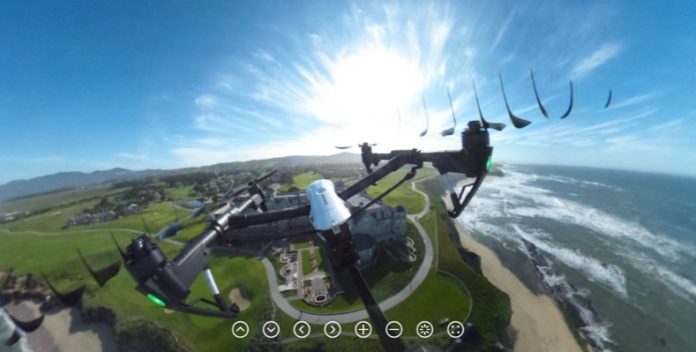 Photo Eric Cheng
At Skyward, we make operations management software for companies that use drones, so business managers and drone operators often ask us questions regarding safety, workflow, best practices, and business efficiency. These are great questions that most businesses are focused on—and that our software specifically addresses.
We also receive dozens of questions each week about something altogether different: “I just bought a drone; how do I make money with it?”
This article is a resource for new drone operators who are wondering how to find customers, specialise, and use their drone to make money.
One thing to keep in mind is that you are providing a service, which means that you can’t create value out of thin air. You’ll need to find someone who is willing to pay for your ability to operate your drone, its sensors, and—most importantly—transform the data you gather into a useful product: a heat map, a roof inspection, a real estate video.
Also know that competition is real: Drone sales more than tripled last year, and many of those buyers are trying to start their own businesses too. This is why it’s essential to establish yourself as a professional in the short term in order to benefit from the long-term need for aerial services.
If you’re just learning a fly and you’ve never run a business before, this process will take some time.
1. Become an Expert Drone Pilot

2. Know Drone Regulations
Knowing how to fly a drone expertly and safely is the first step, but understanding the regulations is just as important. Every business, no matter what industry or jurisdiction, must follow certain regulations—paying taxes, for example, and filing paperwork for employees or contractors. If you fly a drone commercially in the United States, the FAA requires that you pass a test to show that you understand airspace rules and safe drone operation. In Canada, drone operators must apply for an SFOC for a specific region. The Skyward Airspace Map makes it easy to understand airspace regulations all over the world. Keep in mind that your city and state may have additional regulations regarding drones.
UAV liability insurance isn’t a requirement in every country, but if you’d like to do jobs for other businesses or corporations, they will likely require proof of insurance before they hire you.
3. Create Strong Systems of Accountability
Download our free guide for more detailed information on how to plan and execute drone flights. Put in the hours, and document every flight. Not just for safety’s sake, and to know when maintenance is due—logged hours are a potential client’s best way of gauging your level of experience and ability when considering you as a potential hire.
Develop a general operating manual that goes over every part of your flight plan in the form of an easy to follow checklist.
Setting up the launch and landing area? Check.
Examine the aircraft for any potential points of failure? Check.
Clear the area of any people not participating in the flight? Check.
Having this documentation not only makes your business more legitimate in the eyes of the world, it reduces your risk of accidents, and consequently lowers your insurance rates. You can use Skyward to keep track of your safety record, and show off your robust accountability systems.
4. Identify Your Area of Expertise
Once you’ve established a framework for your operations, the question becomes, “Which market should I serve?” Too many drone operators skip this step before setting up shop. Starting a business is always a risk, and starting a business without having any idea who your customers will be is a recipe for heartache.
Don’t let this happen to you.
Your client base will depend on your drone and sensors, your data processing expertise, your location, and your interests. Are you in a rural area? Agriculture is an industry that has been hungry for drones to provide a cheaper alternative for crop inspections and a slew of other tasks. Take a look at how PrecisionHawk is serving this market, for example, by giving farmers the ability to manage their crops, maximize yields, and monitor their assets. In this case, which involves collecting data on large tracts of land, you would need to invest in a fixed-wing drone, appropriate sensors, and software to transform raw data into reports that farmers can understand and act upon.
Gathering data is one thing and processing it is another question entirely. Software is the key that unlocks the raw sensor information, allowing you to offer your clients more than just aerial photography.
Another opportunity in rural areas is engineering. POWER Engineers uses drones to route high voltage transmission lines. Other opportunities exist in areas that are growing their energy infrastructure, from wind and solar, to oil and natural gas.
If you are in a more populated area, particularly one that is experiencing growth, there are plenty of opportunities in construction. Keep in mind that some cities have restricted airspace, which will require a waiver from the FAA, but that shouldn’t stop you from applying — they are happy to work with commercial pilots who are able to prove their operations are safe and consistent.
The list of use cases for drones in construction is enough to fill its own article, and the number of opportunities will only continue to grow as technology develops: inspections, job site monitoring, surveying, and creating 3D models and real estate photography are only the tip of the proverbial iceberg.
5. Market Yourself…
Whichever sector you decide to target, keep in mind that these companies are going to want to make sure they’re hiring the most capable, experienced, and accountable pilots. How you market your business is a key part of being perceived this way. Document your flights, log your hours, and build an attractive website that shows off what deliverables you can offer, what insurance you have, and offer customers a range of pricing options to suit a wider set of needs.
Skyward’s Resource Library is full of information on how to improve and manage your drone operation, so be sure to read through our resources to get a more detailed picture of how best to approach this industry. When you feel ready to look for work, our Pilot Finder is a fantastic tool for pilots and businesses to connect, and can help you get started on the journey to becoming a successful UAV operator.
… or Take Your Talents to the Job Market
Many business owners find that they spend the majority of their time on tasks that don’t make any money such as accounting, filing forms, completing proposals, managing employees and doing work on spec. Some entrepreneurs are surprised at how much time they spend on sales and marketing. If you find that running a business is too stressful and expensive, consider looking for employment at large fleet operators, such as Talon, Measure, and Uplift, or large companies with drone operations.
Business managers at larger organizations consistently tell us that their number-one challenge is hiring experienced, qualified drone pilots. So if you have solid flight experience, knowledge of the regulations and standard operating procedures, an understanding of data processing, and a great work ethic, your talents will be in demand.
By Jessica Moody
22 February 2017
Photo Eric ChengAt Skyward, we make operations management software for companies that use drones, so business managers and drone operators often ask us questions regarding safety, workflow, best practices, and business efficiency. These are great questions that most businesses are focused on—and that our software specifically addresses.
We also receive dozens of questions each week about something altogether different: “I just bought a drone; how do I make money with it?”
This article is a resource for new drone operators who are wondering how to find customers, specialise, and use their drone to make money.
One thing to keep in mind is that you are providing a service, which means that you can’t create value out of thin air. You’ll need to find someone who is willing to pay for your ability to operate your drone, its sensors, and—most importantly—transform the data you gather into a useful product: a heat map, a roof inspection, a real estate video.
Also know that competition is real: Drone sales more than tripled last year, and many of those buyers are trying to start their own businesses too. This is why it’s essential to establish yourself as a professional in the short term in order to benefit from the long-term need for aerial services.
If you’re just learning a fly and you’ve never run a business before, this process will take some time.
1. Become an Expert Drone Pilot
The first step to becoming a successful commercial drone pilot is learning to fly your UAV safely as a hobbyist. In our last webinar, 65 Pro Tips (download the recording and companion guide here) Alan Perlman of Drone Pilot Ground School went over a basic checklist for mastering multi-rotor rotation.
Hover at eye-level
Hover and yaw, left and right
Achieve targeted take-offs and landings
Fly a square pattern, with and without yaw
Fly a circle pattern, with and without yaw
Fly a figure-8 pattern, with and without yaw
Achieve a 180-degree inverted landing
Hover at eye-level
Hover and yaw, left and right
Achieve targeted take-offs and landings
Fly a square pattern, with and without yaw
Fly a circle pattern, with and without yaw
Fly a figure-8 pattern, with and without yaw
Achieve a 180-degree inverted landing
2. Know Drone Regulations
Knowing how to fly a drone expertly and safely is the first step, but understanding the regulations is just as important. Every business, no matter what industry or jurisdiction, must follow certain regulations—paying taxes, for example, and filing paperwork for employees or contractors. If you fly a drone commercially in the United States, the FAA requires that you pass a test to show that you understand airspace rules and safe drone operation. In Canada, drone operators must apply for an SFOC for a specific region. The Skyward Airspace Map makes it easy to understand airspace regulations all over the world. Keep in mind that your city and state may have additional regulations regarding drones.
UAV liability insurance isn’t a requirement in every country, but if you’d like to do jobs for other businesses or corporations, they will likely require proof of insurance before they hire you.
3. Create Strong Systems of Accountability
Download our free guide for more detailed information on how to plan and execute drone flights. Put in the hours, and document every flight. Not just for safety’s sake, and to know when maintenance is due—logged hours are a potential client’s best way of gauging your level of experience and ability when considering you as a potential hire.
Develop a general operating manual that goes over every part of your flight plan in the form of an easy to follow checklist.
Setting up the launch and landing area? Check.
Examine the aircraft for any potential points of failure? Check.
Clear the area of any people not participating in the flight? Check.
Having this documentation not only makes your business more legitimate in the eyes of the world, it reduces your risk of accidents, and consequently lowers your insurance rates. You can use Skyward to keep track of your safety record, and show off your robust accountability systems.
4. Identify Your Area of Expertise
Once you’ve established a framework for your operations, the question becomes, “Which market should I serve?” Too many drone operators skip this step before setting up shop. Starting a business is always a risk, and starting a business without having any idea who your customers will be is a recipe for heartache.
Don’t let this happen to you.
Your client base will depend on your drone and sensors, your data processing expertise, your location, and your interests. Are you in a rural area? Agriculture is an industry that has been hungry for drones to provide a cheaper alternative for crop inspections and a slew of other tasks. Take a look at how PrecisionHawk is serving this market, for example, by giving farmers the ability to manage their crops, maximize yields, and monitor their assets. In this case, which involves collecting data on large tracts of land, you would need to invest in a fixed-wing drone, appropriate sensors, and software to transform raw data into reports that farmers can understand and act upon.
Gathering data is one thing and processing it is another question entirely. Software is the key that unlocks the raw sensor information, allowing you to offer your clients more than just aerial photography.
Another opportunity in rural areas is engineering. POWER Engineers uses drones to route high voltage transmission lines. Other opportunities exist in areas that are growing their energy infrastructure, from wind and solar, to oil and natural gas.
If you are in a more populated area, particularly one that is experiencing growth, there are plenty of opportunities in construction. Keep in mind that some cities have restricted airspace, which will require a waiver from the FAA, but that shouldn’t stop you from applying — they are happy to work with commercial pilots who are able to prove their operations are safe and consistent.
The list of use cases for drones in construction is enough to fill its own article, and the number of opportunities will only continue to grow as technology develops: inspections, job site monitoring, surveying, and creating 3D models and real estate photography are only the tip of the proverbial iceberg.
5. Market Yourself…
Whichever sector you decide to target, keep in mind that these companies are going to want to make sure they’re hiring the most capable, experienced, and accountable pilots. How you market your business is a key part of being perceived this way. Document your flights, log your hours, and build an attractive website that shows off what deliverables you can offer, what insurance you have, and offer customers a range of pricing options to suit a wider set of needs.
Skyward’s Resource Library is full of information on how to improve and manage your drone operation, so be sure to read through our resources to get a more detailed picture of how best to approach this industry. When you feel ready to look for work, our Pilot Finder is a fantastic tool for pilots and businesses to connect, and can help you get started on the journey to becoming a successful UAV operator.
… or Take Your Talents to the Job Market
Many business owners find that they spend the majority of their time on tasks that don’t make any money such as accounting, filing forms, completing proposals, managing employees and doing work on spec. Some entrepreneurs are surprised at how much time they spend on sales and marketing. If you find that running a business is too stressful and expensive, consider looking for employment at large fleet operators, such as Talon, Measure, and Uplift, or large companies with drone operations.
Business managers at larger organizations consistently tell us that their number-one challenge is hiring experienced, qualified drone pilots. So if you have solid flight experience, knowledge of the regulations and standard operating procedures, an understanding of data processing, and a great work ethic, your talents will be in demand.
Read more:
Tuesday, February 21, 2017
New Russian Reconnaissance Drone Unveiled at IDEX
uasvision.com
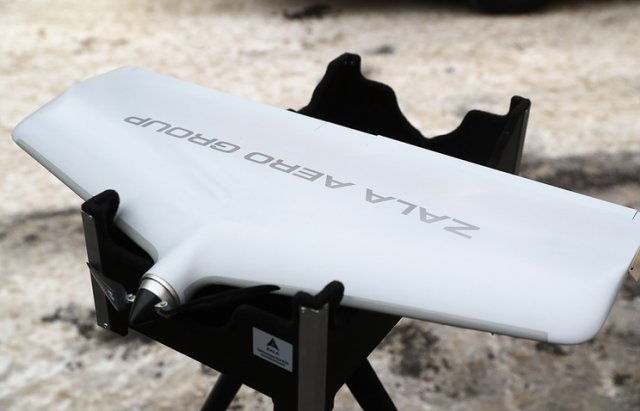
Zala Aero Group, part of the Kalashnikov Group, has unveiled its newest reconnaissance unmanned aerial vehicle, which has been put into serial production, spokeswoman for the Group Sofya Ivanova told TASS on Monday.The new reconnaissance drone was unveiled at the IDEX-2017 arms show in Abu Dhabi, the spokeswoman said.
“As part of the IDEX-2017 international arms exhibition in Abu Dhabi, the presentation of the Russian aircraft-type unmanned reconnaissance and surveillance system ZALA 421-16E2 was held. The drone has been put into serial production and will soon begin to be supplied to customers,” the spokeswoman said.
The new drone has a takeoff weight of 7.5 kg and a guaranteed flight endurance of four hours with an electrical engine even in harsh weather conditions of minus 40 degrees Celsius.
A daytime camera with a 60-time optical zoom and a thermal imaging device of tenfold optical scope are installed on the drone as the targeted 1.5 kg payload.
“The drone is an all-weather and round-the-clock system. It can transmit video data in complex weather conditions to a distance of no less than 30 km while the radius of its control in harsh weather is no less than 50 km,” the spokeswoman said.
The drone’s inbuilt inertial system, its radar range finder and the bloc of self-diagnostics sensors provide for the unmanned aerial vehicle’s fully autonomous operation from the GPS/GLONASS satellite navigation systems, she added.
“The drone’s first deliveries will be made at the end of this quarter. The new system has been developed amid increased secrecy: the drone’s minimum size allows accomplishing tasks, which earlier required aerial vehicles weighing several times more and based on the use of mechanical or pneumatic catapults,” the spokeswoman said.
Source: TASS
Read more:
http://www.uasvision.com/2017/02/21/new-russian-reconnaissance-drone-unveiled-at-idex/#more-48514
February 21, 2017
Zala Aero Group, part of the Kalashnikov Group, has unveiled its newest reconnaissance unmanned aerial vehicle, which has been put into serial production, spokeswoman for the Group Sofya Ivanova told TASS on Monday.The new reconnaissance drone was unveiled at the IDEX-2017 arms show in Abu Dhabi, the spokeswoman said.
“As part of the IDEX-2017 international arms exhibition in Abu Dhabi, the presentation of the Russian aircraft-type unmanned reconnaissance and surveillance system ZALA 421-16E2 was held. The drone has been put into serial production and will soon begin to be supplied to customers,” the spokeswoman said.
The new drone has a takeoff weight of 7.5 kg and a guaranteed flight endurance of four hours with an electrical engine even in harsh weather conditions of minus 40 degrees Celsius.
A daytime camera with a 60-time optical zoom and a thermal imaging device of tenfold optical scope are installed on the drone as the targeted 1.5 kg payload.
“The drone is an all-weather and round-the-clock system. It can transmit video data in complex weather conditions to a distance of no less than 30 km while the radius of its control in harsh weather is no less than 50 km,” the spokeswoman said.
The drone’s inbuilt inertial system, its radar range finder and the bloc of self-diagnostics sensors provide for the unmanned aerial vehicle’s fully autonomous operation from the GPS/GLONASS satellite navigation systems, she added.
“The drone’s first deliveries will be made at the end of this quarter. The new system has been developed amid increased secrecy: the drone’s minimum size allows accomplishing tasks, which earlier required aerial vehicles weighing several times more and based on the use of mechanical or pneumatic catapults,” the spokeswoman said.
Source: TASS
Read more:
http://www.uasvision.com/2017/02/21/new-russian-reconnaissance-drone-unveiled-at-idex/#more-48514
Developing VTOL Tech To Redefine Urban Mobility With Flying Cars, Airbus Taxis
droneblog.com
By Allison Crady
February 20, 2017

It’s the year 2017, and everyone has a car. Each year as the population increases, so do the number of cars on the road. In America, we have the highest vehicle-to-person ration at one car for every 1.3 people. With over a billion cars on the road, auto congestion is rough.
The current state of urban mobility looks like a concrete lot full of motionless cars, smells like chemically toxic air, and feels like the tension of an angry traffic mob. In efforts to increase walkability, clean our air, and negate traffic times, brilliant engineers are developing technology to reshape how we experience mobility in the 21st century.
Last year was full of milestones in the realm of driverless technologies, with several successful test runs through Uber and Google’s startup Otto. This year drone deliveries will be hitting the market for widespread commercial application with Amazon’s “Prime Air.”
With driverless technologies and drone capabilities nearly developed, it’s only a matter of time before they combine and we have flying cars and airbus taxis.
Several skyway projects are already underway. Vertical take-off and landing technologies (VTOL) are being tested around the world.
Uber has openly invested into a flying car project known as “Uber Elevate.” Google founder Larry Page has openly invested millions into flying car start-ups and has been working on a fly car model project of his own. Airbus’s Urban Air Mobility announced prototype testing later this year.
With VTOL technology, flying taxis are expected to hit broad scale production as soon as 2021. Much like Uber or Lyft, an airbus could be summoned using an app on your smart phone.
Watch the news and begin dreaming of tomorrow’s world. Don’t surprised when you find yourself riding a flying drone to work.
THE CURRENT STATE OF URBAN MOBILITY
As we dream of flying cars and numerous tech gadgets are developed, techies have yet to solve the daily struggle of rush hour. In cities like San Francisco, traffic jams are omnipresent. The average American commuter will spend 42 hours stuck in traffic each year. All of this congestion leads to poor physical and mental states.
The biggest criminal in the crime of our filthy air is the car we drive to work every day. As you drive into a city like Nashville, you can see a cloud of smog hovering over the buildings. Our vehicle transportation system with its toxic CO2 emissions is a huge contributor to the current state of air pollution.
American cities were developed largely after 1950s, when automobiles were becoming mainstream. Given our excellent economy, U.S. cities rapidly developed over the last century. With everyone driving cars, the cities naturally became auto-centric thus creating suburban sprawl. Infrastructure planners designed widening streets along with ample concrete parking lots and garages. In many cities public transit systems have been unable to keep up, which leads to more constituents driving cars every day.
Despite suburban sprawls, a few U.S. metro cities have done well with effective public transportation such as trains, subways and buses. New York, San Francisco, Washington D.C., Boston, Philadelphia and Chicago to name a few. Cities like Portland have gone a step farther to clear the air by creating a conducive cyclist culture. Now apps like Uber and Lyft are making it even easier to leave he car at home.
Our cities are made for cars, yet auto accidents are the leading cause of death for American teens. Across the country, automobile deaths total over 1.3 million every year. If smog pollution weren’t enough of an issue, the violence of car crashes should cause some second thoughts. For many factors of human safety and prolonged existence, it’s crucial that we seriously rethink our method of transportation.
VTOL DEVELOPMENT, AIRBUS TAXIS, AND FLYING CARS
Brightening the horizons of clean air, we can dream of the transportation filled with electric flying cars and smart cities. Futuristic developers like Elon Musk and the minds of Uber are creating the transportation of tomorrow. This helicopter-styled vehicle is the next step.
Co-founder of London transport design studio, Paul Priestman, predicts passenger-carrying drones for the future. He believes they would resemble scaled-up drones. Around the world engineers are tinkering with startup projects and creating pilot runs for flying cars.
Just this month Uber appointed a NASA engineer to help expand cab services into airborne travel. The pilotless flying service would utilize electric energy instead of gasoline.
Also this month Project Vahana in Silicon Valley was launched for a single-passenger flying vehicle. A3 CEO Rodin Lyasoff said, “In as little as ten years, we could have products on the market that revolutionize urban travel for millions of people.”
In January Chinese drone maker EHang, CEO of Huazhi Hu, showed off his personal autonomous helicopter. The electric car can carry a single passenger up to 10 miles away, or about 23 minutes of flight time. Ehang describes it as faster, easier and more convenient. He imagines luxury rides for the rich ones will characterize the first phase of autonomous aircrafts.
The Civil Aviation Authority of Singapore have their hands deep into skyway projects for airbus helicopters. With the help of Airbus Helicopters, their Skyway Experimentation Project is creating an airborne infrastructure solution.
Experts have said that autonomous flying is easier than autonomous driving. The self-driving car industry has already made so much progress. Last year Google successfully sent a driverless truck on a 120-mile trek. Last summer Uber piloted autonomous fleet sharing in Pittsburgh. Technicians are simply working out the tweaks of radar sensors and vehicle response to the numerous potential obstacles.
Flying cars are not as far out as you might imagine. With the recent development of drone delivery, the Federal Aviation Administration (FAA) has begun sorting out potential issues and airspace regulations. FAA has quickly adapted to account for increasing air traffic and make way for pilotless bots.
START DREAMING OF A BRIGHTER FUTURE
Imagine the economic impact when city planners don’t have to spend billions of dollars to pour concrete for bridges and roads. Along with the development of smart devices connecting through the Internet of Things, urban mobility will continue to improve in efficiency.
The way we move will transcend, becoming safer, faster and more energy efficient. Within the next decade or two, our cities will change. Flying vehicles will revolutionize urban traffic for millions of people.
Read more:
http://droneblog.com/2017/02/20/developing-vtol-tech-to-redefine-urban-mobility-with-flying-cars-airbus-taxis/
Drone jobs: Cyberhawk on the hunt for new talent
suasnews.com
By Press
20 February 2017
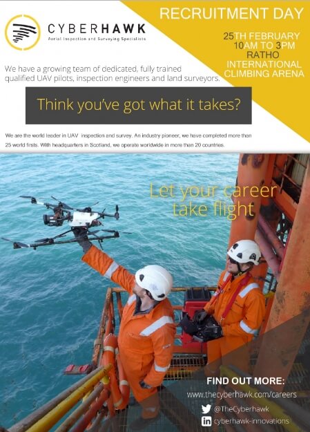
Cyberhawk Innovations, leader in aerial inspection and survey using Unmanned Aerial Vehicles (UAV), is offering to drone enthusiasts a rare opportunity to become part of one of the world’s fastest growing industries.
Headquartered in Livingston, and with bases in Houston, the Middle East and Southeast Asia, Cyberhawk carried out the very first UAV inspection in 2009. The company works across the oil and gas, renewables, utilities and infrastructure sectors and has completed over 25 world firsts.
This Saturday (25 February), Cyberhawk will be on the hunt for UAV pilots and inspection engineers to join its team as it hosts an open day at the Edinburgh International Climbing Centre in Ratho, Edinburgh.
As a minimum, budding pilots will need to possess strong communication and problem solving skills, professionalism, willingness to travel and an awareness of the current Civil Aviation Authority (CAA) regulations. Interviewees for this position will also undertake a flight skills assessment using small trainer UAV.
The inspection engineering roles will involve the inspection of UAV data, image processing and defect analysis, and would be suited to those who have recently graduated, or are studying towards a mechanical, civil or structural engineering degree. All recruits will receive full training.
Chris Fleming, CEO at Cyberhawk said: “This is a great chance to become part of one of Scotland’s global success stories, at a company which really is at the top of its game.
“As well as those with aviation experience and knowledge under their belt, this is also an exciting opportunity for drone hobbyists, or those with an interest and enthusiasm in the technology, to embark upon a career in this fast-paced, fast-growth industry.
“We’re excited to uncover the new talent who will help Cyberhawk continue to grow and maintain its world leading position. We encourage anyone interested to come along on Saturday so they don’t miss out on this fantastic opportunity.”
http://www.thecyberhawk.com/cyberhawk-hunt-new-talent/
Read more:
https://www.suasnews.com/2017/02/cyberhawk-hunt-new-talent/
By Press
20 February 2017
Cyberhawk Innovations, leader in aerial inspection and survey using Unmanned Aerial Vehicles (UAV), is offering to drone enthusiasts a rare opportunity to become part of one of the world’s fastest growing industries.
Headquartered in Livingston, and with bases in Houston, the Middle East and Southeast Asia, Cyberhawk carried out the very first UAV inspection in 2009. The company works across the oil and gas, renewables, utilities and infrastructure sectors and has completed over 25 world firsts.
This Saturday (25 February), Cyberhawk will be on the hunt for UAV pilots and inspection engineers to join its team as it hosts an open day at the Edinburgh International Climbing Centre in Ratho, Edinburgh.
As a minimum, budding pilots will need to possess strong communication and problem solving skills, professionalism, willingness to travel and an awareness of the current Civil Aviation Authority (CAA) regulations. Interviewees for this position will also undertake a flight skills assessment using small trainer UAV.
The inspection engineering roles will involve the inspection of UAV data, image processing and defect analysis, and would be suited to those who have recently graduated, or are studying towards a mechanical, civil or structural engineering degree. All recruits will receive full training.
Chris Fleming, CEO at Cyberhawk said: “This is a great chance to become part of one of Scotland’s global success stories, at a company which really is at the top of its game.
“As well as those with aviation experience and knowledge under their belt, this is also an exciting opportunity for drone hobbyists, or those with an interest and enthusiasm in the technology, to embark upon a career in this fast-paced, fast-growth industry.
“We’re excited to uncover the new talent who will help Cyberhawk continue to grow and maintain its world leading position. We encourage anyone interested to come along on Saturday so they don’t miss out on this fantastic opportunity.”
http://www.thecyberhawk.com/cyberhawk-hunt-new-talent/
Read more:
https://www.suasnews.com/2017/02/cyberhawk-hunt-new-talent/
Monday, February 20, 2017
Waterproof drone wins prize
The Drone News
February 19, 2017

The winning projects included a drone that can fly and land on water to save a person from drowning
They invested only a few thousand dirhams and lots of hours into building their drones, now they are walking away with millions in cash.
A total of four winners were announced at the AI/Robotics for Good Award and the UAE Drones for Good Award, where the two national teams won Dh1 million each and the international teams bagged $1 million each.
This was the third annual competition at Dubai Internet City, which encourages tech fans to build drones or robots that can help humanity in some way.
The winning projects included a drone that can fly and land on water to save a person from drowning, a drone that save people in disaster-hit areas, a robot that can detect gas leaks and a robotic limb.
The team from Sanad Academy in Dubai won Dh1 million in the national category for drones, with their invention called the ‘Smart Ring’.
Mohammad Aziz from Sanad Academy said: “The aim is to save lives that are being lost in beaches because of drowning. The Smart Ring is inspired by the traditional live-saving ring but it’s infused with drone technology.
The lifeguards can simply use the smart ring app and deploy it to rescue victims.
“The best part is you don’t really need a lot of skills to use it, you can use it through a mobile app. The drone can fly, but it can also go to the victim in the water and save them. You can also have multiple rings sending signals to each other.
“Another key feature of this project, it’s 3D printed, which helps a lot in the water proof. The entire drone is printed out in only two to three parts, meaning that it can be built in larger quantities.
“With the million dirhams, we plan on improvising our project, even though we think our product is ready for the market. We want to reinvest it so we can build a drone that swim under water, a smarter ring that can go beneath the ocean.”
The Nokia team won $1 million in the international category. One of the team members, Thomas Eder, explained that the invention ‘Nokia Saving Lives’ was created to help people who are stuck in disaster-hit areas. The team intends to use the money so they can build partnerships around the world and send help to wider areas.
Eder said: “Nokia Saving Life is a non-profit initiative, where we used Nokia’s LTE technology to connect the drones with a ground station. That solution is specifically designed for disaster scenarios with NGOs, such as the United Nations or Red Crescent.
” We want to make rescue operations more efficient. We want to make sure rescues can be faster in the future. We really believe that with the LTE technology, with our drones and our video analytics we can really make the difference in the future.”
Meet the winners in AI/Robotics category
While drones are slowly taking over the world, robotics are following closely behind. Millions of dirhams were given away to teams who built robotic inventions for the Dubai competition.
Daniel Waleed from the American University of Sharjah (AUS) and his team won Dhs1 million in the national category of the UAE AI/Robotic for Good Awards.
Waleed, 24, and his partners worked tirelessly for three years to build the In-Pipe Inspection Robot, which detects gas leaks inside pipes.
He said: “The purpose of our project is to detect gas leaks in pipelines. The research took us two years, we had three prototypes initially. The first and second one took us one year each and it took us six months to combine both robots to build the final one.
“We have three sensors in the robot, which allows us to cover the entire pipe. It can also detect where the pipe is leaking. When it’s going through the pipeline, it can tell the operator that a leak has been detected.”
Joel Gibbard and his team from the UK bagged $1 million in the international category of the award. Their project, called ‘Open Bionics’, consisted of a bionic arm.
Gibbard said: “Open Bionics is 3D printed, affordable and are advanced robotic arms for amputees. There’s a huge need for advanced robotic limbs and we wanted to make something that was really advanced technology and affordable. The money is going to be incredibly useful. It’s going to hospital certifications and providing these limbs to young patients.”
They didn’t win big but proud of their innovations for refugees
What does one do when a “sneaky” immigrant or refugee is trying to swim into your country? You build a drone that can detect them coming in – this was the message and invention from a Portuguese company at the UAE Drones for Good Awards.
Eduardo Pinto, one of the creators of the Drones4Right2Life project, made it clear that the drone wasn’t built to “save lives”, instead to detect immigrants on boats who are trying to come into a country. Pinto’s team did not win any of the prizes, but they were still very proud of their invention.
Pinto said: “This is a water-proof drone that helps detects immigrants in the Mediterranean Sea. There would be a network of drones over the sea that can detect. In Portugal, we have a problem with lots immigrants coming in. We are trying to present a solution.
“Lots of Syrian refugees died while trying to cross the ocean so they can go to Europe, but that’s very dangerous. Our drones will help detect if they are doing something like that.” Another drone at the competition tapped into the topic of refugees, war and terror – however, they aimed to save lives.
Rafael Mongelos, one of the ‘Mine Kafon’ drone creators, said: “The drone detects and detonates landmines. Landmines are explosions that are underground and they are used in war. “These explosions are below the ground and almost every minute someone is injured by them. The drone can detect and disarm landmine at a safe distance.
sarwat@khaleejtimes.com
February 19, 2017
The winning projects included a drone that can fly and land on water to save a person from drowning
They invested only a few thousand dirhams and lots of hours into building their drones, now they are walking away with millions in cash.
A total of four winners were announced at the AI/Robotics for Good Award and the UAE Drones for Good Award, where the two national teams won Dh1 million each and the international teams bagged $1 million each.
This was the third annual competition at Dubai Internet City, which encourages tech fans to build drones or robots that can help humanity in some way.
The winning projects included a drone that can fly and land on water to save a person from drowning, a drone that save people in disaster-hit areas, a robot that can detect gas leaks and a robotic limb.
The team from Sanad Academy in Dubai won Dh1 million in the national category for drones, with their invention called the ‘Smart Ring’.
Mohammad Aziz from Sanad Academy said: “The aim is to save lives that are being lost in beaches because of drowning. The Smart Ring is inspired by the traditional live-saving ring but it’s infused with drone technology.
The lifeguards can simply use the smart ring app and deploy it to rescue victims.
“The best part is you don’t really need a lot of skills to use it, you can use it through a mobile app. The drone can fly, but it can also go to the victim in the water and save them. You can also have multiple rings sending signals to each other.
“Another key feature of this project, it’s 3D printed, which helps a lot in the water proof. The entire drone is printed out in only two to three parts, meaning that it can be built in larger quantities.
“With the million dirhams, we plan on improvising our project, even though we think our product is ready for the market. We want to reinvest it so we can build a drone that swim under water, a smarter ring that can go beneath the ocean.”
The Nokia team won $1 million in the international category. One of the team members, Thomas Eder, explained that the invention ‘Nokia Saving Lives’ was created to help people who are stuck in disaster-hit areas. The team intends to use the money so they can build partnerships around the world and send help to wider areas.
Eder said: “Nokia Saving Life is a non-profit initiative, where we used Nokia’s LTE technology to connect the drones with a ground station. That solution is specifically designed for disaster scenarios with NGOs, such as the United Nations or Red Crescent.
” We want to make rescue operations more efficient. We want to make sure rescues can be faster in the future. We really believe that with the LTE technology, with our drones and our video analytics we can really make the difference in the future.”
Meet the winners in AI/Robotics category
While drones are slowly taking over the world, robotics are following closely behind. Millions of dirhams were given away to teams who built robotic inventions for the Dubai competition.
Daniel Waleed from the American University of Sharjah (AUS) and his team won Dhs1 million in the national category of the UAE AI/Robotic for Good Awards.
Waleed, 24, and his partners worked tirelessly for three years to build the In-Pipe Inspection Robot, which detects gas leaks inside pipes.
He said: “The purpose of our project is to detect gas leaks in pipelines. The research took us two years, we had three prototypes initially. The first and second one took us one year each and it took us six months to combine both robots to build the final one.
“We have three sensors in the robot, which allows us to cover the entire pipe. It can also detect where the pipe is leaking. When it’s going through the pipeline, it can tell the operator that a leak has been detected.”
Joel Gibbard and his team from the UK bagged $1 million in the international category of the award. Their project, called ‘Open Bionics’, consisted of a bionic arm.
Gibbard said: “Open Bionics is 3D printed, affordable and are advanced robotic arms for amputees. There’s a huge need for advanced robotic limbs and we wanted to make something that was really advanced technology and affordable. The money is going to be incredibly useful. It’s going to hospital certifications and providing these limbs to young patients.”
They didn’t win big but proud of their innovations for refugees
What does one do when a “sneaky” immigrant or refugee is trying to swim into your country? You build a drone that can detect them coming in – this was the message and invention from a Portuguese company at the UAE Drones for Good Awards.
Eduardo Pinto, one of the creators of the Drones4Right2Life project, made it clear that the drone wasn’t built to “save lives”, instead to detect immigrants on boats who are trying to come into a country. Pinto’s team did not win any of the prizes, but they were still very proud of their invention.
Pinto said: “This is a water-proof drone that helps detects immigrants in the Mediterranean Sea. There would be a network of drones over the sea that can detect. In Portugal, we have a problem with lots immigrants coming in. We are trying to present a solution.
“Lots of Syrian refugees died while trying to cross the ocean so they can go to Europe, but that’s very dangerous. Our drones will help detect if they are doing something like that.” Another drone at the competition tapped into the topic of refugees, war and terror – however, they aimed to save lives.
Rafael Mongelos, one of the ‘Mine Kafon’ drone creators, said: “The drone detects and detonates landmines. Landmines are explosions that are underground and they are used in war. “These explosions are below the ground and almost every minute someone is injured by them. The drone can detect and disarm landmine at a safe distance.
sarwat@khaleejtimes.com
Read more:
MMC Introduces Next Gen of Hydrogen Drone – the HyDrone 1800
dronelife.comBY FRANK SCHROTH
FEBRUARY 20, 2017

FEBRUARY 20, 2017
Together with CATIC, MMC, the drone manufacturer, unveiled the HyDrone 1800 at the International Defense Exhibition and Conference (IDEX 2017) taking place at the Abu Dhabi national exhibition center. It represents the next generation of its hydrogen technology and the firms said it is designed for the military.
The carbon-fiber HyDrone 1800 is an almost indestructible aircraft. Designed for use in the toughest conditions, the drone is wind-resistant, rain-resistant, cold-resistant and still incredibly lightweight. The HyDrone 1800’s hydrogen fuel cell technology is its most notable feature and, according to MMC, provides a flight endurance of 4 hours or of a remarkable 50+ hours when combined with MMC tethered technology. The endurance of the hydrogen drone changes the scope of applications: most military or industrial drones currently on the market are limited by flight times of under 1 hour. HyDrone 1800 achieves the extended flight time while maintaining altitude limits of 4500 meters – competitive or better than other similar sized aircraft – and a payload capacity of up to 5kg.
Hydrogen fuel cell technology is a breakthrough for drones. The technology is an environmentally friendly solution towards a drone industry bottleneck: flight endurance. Constructed for safety and durability, an auxiliary lithium battery starts the fuel cell and provides a backup source of power for the drone. The properties of hydrogen fuel not only allow for extraordinary flight time, but extend the ideal temperature range for operation. Hydrogen drones can be flown in extreme temperatures – from -10 degrees Celsius to 40 degrees Celsius.
“This technology is the next step forward for military grade drones,” says MMC’s founder Lu Zhi Hui. “It’s safe, it’s effective, it’s proven – and the endurance is unmatched by other power sources. ”
Payloads can be changed quickly and easily. Operators may choose from payloads including a thermal imaging camera, low light camera, laser equipment, or zoom camera; making the system ideal for many military applications. HyDrone 1800 can be used for intelligence gathering, border patrol, aerial fire support, laser designation, or battle management services to tactical military operators. MMC also offers packaged solutions in target acquisition and reconnaissance technology (ISTAR).
Read more:
New Video of NASA BVLOS Detect-and-Avoid Tests
dronelife.comBY MIRIAM MCNABB
FEBRUARY 20, 2017

NASA Senior Flight Engineer Dr. Ricardo Arteaga and Vigilant Aerospace CEO Kraettli Epperson on-site for beyond line-of-sight testing at NASA Armstrong, Image courtesy Vigilant
Vigilant Aerospace, in collaboration with the FAA and NASA, has completed beyond visual-line-of-sight (BVLOS) flight testing of its new FlightHorizon collision avoidance system for drones. The company has released a 90 second video explaining the process, software, and results.
The successful completion of these tests would seem to indicate another step forward towards regulations that may allow BVLOS flight as part of regular commercial drone operation. Vigilant’s flight safety software – FlightHorizon – is based on a NASA patent and prototype, to which they hold the exclusive license.
Tests were performed by Vigilant at NASA Armstrong Flight Research Center in the Mojave desert. Representatives from the FAA, FCC, NASA and airfield safety officers were all present as professional drone operators flew nearly 100 flights with two DJI Phantom 4 drones equipped with aviation transponders and a laptop running the FlightHorizon software.
The software provides drone pilots with a visual map of their aircraft’s location and the location of other nearby aircraft and provides air traffic alerts and collision warnings by tracking the drone and all the aircraft around it for tens of miles.
The tests involved 18 encounter scenarios, including beyond line-of-sight flights in which the aircraft were flown at each other from out of sight. The software proved successful in tests: FlightHorizon detected and tracked 100% of the air traffic and warned of all potential collisions.
“FlightHorizon UAS™ is designed to meet the upcoming RTCA SC-228 Phase II Minimum Operating Standards (MOPS)…” says the company. “It is also intended to help unmanned operators obtain a beyond visual line-of-sight waiver under Section 107.200 of the new sUAS Part 107 rules. The product is based on an exclusively licensed patent and software suite developed and tested by NASA at Armstrong Flight Research Center with FAA observation.”
BVLOS flight is not allowed under currently regulations, although FAA Administrator Michael Huerta has promised movement on BVLOS regulations soon.
Read more:
FREE Publication: Best practices for the use of sUAS by the Electric Utility Industry
suasnews.com
By Gary Mortimer
20 February 2017
A weighty and informative report from ORNL penned by Richard Lusk and William Monday. The report is crammed with information useful for any commercial UAS operator. It includes checklists as well. Always good to see other people’s thinking on that subject.
The introduction is bang on as well, top notch, if you are a serious drone pilot don’t continue with your day until you have downloaded this!
Unmanned aircraft have been around longer than anyone reading this preface. Previously the domain of military operations and some dedicated hobbyists, the technology has become commoditized.
Miniaturisation of computational components, mixed with ubiquitous GPS access and leveraged manufacturing economies of scale, has introduced relatively aerodynamically stable personal drones into everyday life.
The change that is upon us now is that the barrier for access to this technology is a few hundred US dollars. A person with no training or experience can purchase one of these machines and fly it into the National Air Space the same day.
The following analogy is one I frequently use when discussing this three-dimensional risk with people who have little experience with aviation, airspace, or UASs.
Let us say that someone goes into a big-box store and purchases a go-cart. Upon leaving the store, he starts the go-cart and immediately drives it across the parking lot; across the interstate, obeying no right of ways or traffic laws or signs; and across people’s property, at random.
People respond, “That’s crazy. No one would do that!” However, that is exactly what many, and perhaps most, new drone “drivers” do.
Read more:
Saturday, February 18, 2017
Power Company Sends Fire-Spewing Drone to Burn Trash Off High-Voltage Wires
gizmodo.com
By Matt Novak
February 17, 2017
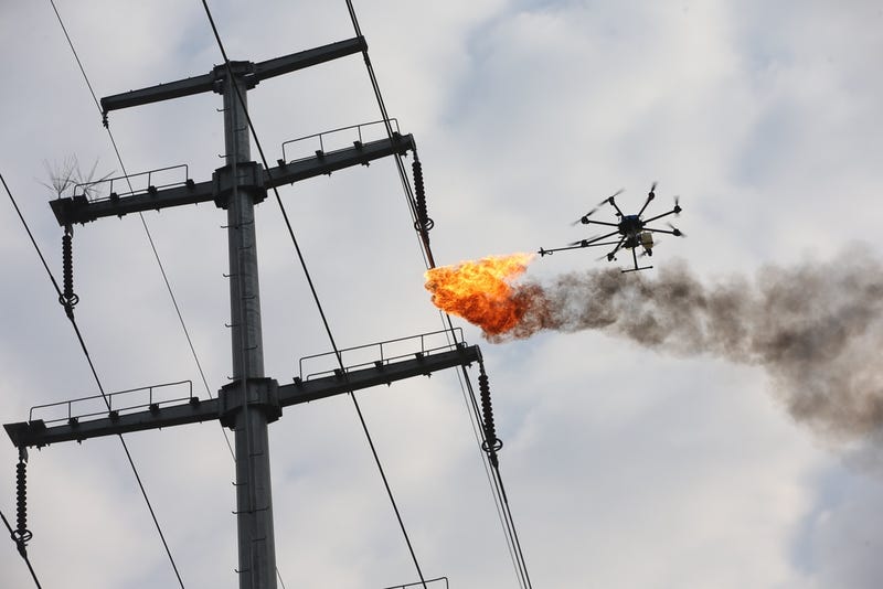
Electric company maintenance workers in Xiangyang, China used a fire-shooting drone to burn garbage from electrical wires (Photo by Wang Hu/VCG)
What happens when your power lines get all kinds of trash hanging from them and it’s not safe to send up a human? In Xiangyang, China, you send in the drones. Specifically, the drones that shoot fire.
Just in case you were worried that the robot uprising was delayed, fear no more. It appears to be right on time, as these fire-spewing drones are sent to burn off trash that gets stuck on high-voltage wires.
The drones are being used by an electric power maintenance company in China to get rid of plastic bags and other debris that get caught in places that are hard to reach with a human in a cherrypicker.
Now, before you get all worried about drones like these being used to kill humans, just remember that drones are already being used to kill humans practically every day. Targeted US military strikes against suspected terrorists occur on a regular basis, and terrorists themselves have gotten into the drone game.
Some reports indicate that terrorist groups such as ISIS are trying to figure out how to deliver chemical weapons via drone. Flame-shooting drones would be tame by comparison.
So when you see headlines like “It’s only a matter of time before a drone kills someone,” it’s important to remember that that time has already come. Let’s not sugarcoat it. We haven’t heard reports about anyone burned to death by this particular style of drone, but that doesn’t mean it hasn’t happened yet.
 Electric company maintenance workers in Xiangyang, China used a fire-shooting drone to burn garbage from electrical wires (Photo by Wang Hu/VCG)
Don’t live in fear about the future. The future is already here.
Read more:
http://gizmodo.com/power-company-sends-fire-spewing-drone-to-burn-trash-of-1792482517
What happens when your power lines get all kinds of trash hanging from them and it’s not safe to send up a human? In Xiangyang, China, you send in the drones. Specifically, the drones that shoot fire.
Just in case you were worried that the robot uprising was delayed, fear no more. It appears to be right on time, as these fire-spewing drones are sent to burn off trash that gets stuck on high-voltage wires.
The drones are being used by an electric power maintenance company in China to get rid of plastic bags and other debris that get caught in places that are hard to reach with a human in a cherrypicker.
Now, before you get all worried about drones like these being used to kill humans, just remember that drones are already being used to kill humans practically every day. Targeted US military strikes against suspected terrorists occur on a regular basis, and terrorists themselves have gotten into the drone game.
Some reports indicate that terrorist groups such as ISIS are trying to figure out how to deliver chemical weapons via drone. Flame-shooting drones would be tame by comparison.
So when you see headlines like “It’s only a matter of time before a drone kills someone,” it’s important to remember that that time has already come. Let’s not sugarcoat it. We haven’t heard reports about anyone burned to death by this particular style of drone, but that doesn’t mean it hasn’t happened yet.
Electric company maintenance workers in Xiangyang, China used a fire-shooting drone to burn garbage from electrical wires (Photo by Wang Hu/VCG)Don’t live in fear about the future. The future is already here.
Read more:
http://gizmodo.com/power-company-sends-fire-spewing-drone-to-burn-trash-of-1792482517
Drones Are Turning Civilians Into an Air Force of Citizen Scientists
wired.com
February 17, 2017
LAST WINTER, AS meteorologists warned of a monster El Niño, researchers at the Nature Conservancy in California prepared to mobilize. El Niño promised to bring in king tides that would raise the sea level by as much as one foot above normal during high tide, causing flooding along the coastline that researchers could study as a preview of climate change-induced sea level rise. But when a king tide arrives, it floods lots of pockets along the coastline at once. So they decided to try a new, distributed surveillance strategy: commercial drones, co-opted from a gung-ho statewide network of citizen scientists.
The plan had a lot of advantages. In January 2016, when the program started, Nature Conservancy researchers would have had to get pilot licenses in order to fly drones themselves. Private, recreational drone pilots have far fewer restrictions. But the plan hiccuped because though the drone operators collected thousands of beach photos, none were taken of the flooding during the king tides’ brief windows. The Nature Conservancy had managed to recruit citizen scientists, but failed to properly coordinate the data collection.
Despite the trouble, drone science is appealing to researchers. Drones are popular, and cloud storage is cheap. But before they deploy an air force of buzzing quadcopters, scientists who recruit citizen pilots need to make sure they are clear about what kind of data they require.
“The importance of the pilot project was to figure out how citizen science data can be useful,” says Kirk Klausmeyer, a spatial data scientist with the Nature Conservancy, “and how it maybe wasn’t as useful as we were hoping.” The Nature Conservancy’s project collected 7,000 images and mapped 1,600 acres of coastline—but the 16 drone operators missed the most scientifically useful data. “We were hoping that the drone operators would be able to get out in a very narrow window of time, during these extreme high tides,” says Klausmeyer. But sometimes the tides arrived inconveniently—at 2am, and again at 4pm on a Thursday. It wasn’t the drone operator’s fault—the Nature Conservancy hadn’t set up a great way to communicate the timing of the tides to operators who were volunteering their time and drones.
 ERIC CHENG/THE NATURE CONSERVANCY
Klausmeyer isn’t the only scientist to find that community drone organizing is hard. Britta Ricker, geographic information scientist at University of Washington, Tacoma, has had difficulty getting a couple of citizen drone science projects off the ground. “I have been trying to reach out to communities that are interested in such projects, but then, they don’t have the mapping software required, or they don’t have the drones because both are expensive,” she says.
The differing FAA regulations for researchers versus private citizens are not at all straightforward. One tangle of rules concerns how nonprofits and universities loan their drones to citizen scientists. These organizations are considered commercial operators, and that status carries over when they give their technology to private citizens. That means those amateur drone operators have to take a test.
As with any scientific research, the key seems to be making sure that citizen experimentalists have the right training and technology. As Margaret Kosmala at Harvard University reported in a December 2016 paper, if citizen scientists are well prepared, their data can be as good or better than the data collected by trained scientists. And because there’s so much of it, the data can have a bigger impact. Some of the most important environmental and conservation datasets of all time come from non-drone citizen scientist projects, like the Christmas Bird Count (started in 1900) and the Cooperative Weather Service (started in 1890).
Don’t buzz the birds
Even as scientists and drone explorers accelerate their citizen science programs, they worry about creating the right culture around drone use in areas that might be sensitive to the ruckus of buzzing blades. For instance, birds.
Ornithologist Andrew Wilson, from Gettysburg College, records birdsong by dangling microphones below drones. This proof-of-principle could allow bird counters to reach normally-inaccessible cliffs and swamps. “One thing we didn’t quite resolve is whether there’s any disturbance impact on the birds,” says Wilson. “The general consensus is that if you don’t get too close, birds are pretty oblivious to it.” But if he’s wrong—if your drone scares off the wildlife—you aren’t going to get accurate wildlife data and may unnecessarily disturb a forest.
Different ecosystems pose different challenges. David Lang, a co-founder of underwater drone-maker OpenROV, wants to avoid people getting too close to sea turtles, whales, and reefs. So he’s actively working with scientists to create guidelines for operators, based on scuba divers’ code of respect for the ocean. On top of that, Lang thinks that object avoidance software could prevent the accidental crash into the coral reef. Aerial drone operators should keep their drone in their line of sight—as they are required to do by FAA regulations—for the same reason.
Hosting drone data
Citizen science creates a lot of data. Organizing and maintaining the data from its coastal El Niño survey is something the Nature Conservancy got right. For this, it partnered with DroneDeploy, a company that processes, and stitches together images that drones collect. “The technical knowhow and cost of imagery stitching is the biggest barrier,” says Ricker, because the software can be so expensive and computation-intensive. But DroneDeploy allowed people participating in the El Niño program to use their software for free to stitch thousands of images together into maps. Ricker is also excited about OpenAerialMap, a platform for sharing drone imagery that’s already been stitched together and processed.
The Nature Conservancy didn’t renew its El Niño program. Partly, because the El Niño was no more. “In retrospect, given all of the flooding we are seeing because of the heightened rain fall, it might have been a good idea,” says Klausmeyer. After the FAA updated their drone regulations last summer to make licenses for commercial operation less complicated to obtain, Klausmeyer got a commercial drone license and now collects drone data for the conservancy himself. He says the weekly requests he gets from people across California to monitor various environmental situations has him considering more citizen drone militias.
LAST WINTER, AS meteorologists warned of a monster El Niño, researchers at the Nature Conservancy in California prepared to mobilize. El Niño promised to bring in king tides that would raise the sea level by as much as one foot above normal during high tide, causing flooding along the coastline that researchers could study as a preview of climate change-induced sea level rise. But when a king tide arrives, it floods lots of pockets along the coastline at once. So they decided to try a new, distributed surveillance strategy: commercial drones, co-opted from a gung-ho statewide network of citizen scientists.
The plan had a lot of advantages. In January 2016, when the program started, Nature Conservancy researchers would have had to get pilot licenses in order to fly drones themselves. Private, recreational drone pilots have far fewer restrictions. But the plan hiccuped because though the drone operators collected thousands of beach photos, none were taken of the flooding during the king tides’ brief windows. The Nature Conservancy had managed to recruit citizen scientists, but failed to properly coordinate the data collection.
Despite the trouble, drone science is appealing to researchers. Drones are popular, and cloud storage is cheap. But before they deploy an air force of buzzing quadcopters, scientists who recruit citizen pilots need to make sure they are clear about what kind of data they require.
“The importance of the pilot project was to figure out how citizen science data can be useful,” says Kirk Klausmeyer, a spatial data scientist with the Nature Conservancy, “and how it maybe wasn’t as useful as we were hoping.” The Nature Conservancy’s project collected 7,000 images and mapped 1,600 acres of coastline—but the 16 drone operators missed the most scientifically useful data. “We were hoping that the drone operators would be able to get out in a very narrow window of time, during these extreme high tides,” says Klausmeyer. But sometimes the tides arrived inconveniently—at 2am, and again at 4pm on a Thursday. It wasn’t the drone operator’s fault—the Nature Conservancy hadn’t set up a great way to communicate the timing of the tides to operators who were volunteering their time and drones.
ERIC CHENG/THE NATURE CONSERVANCYKlausmeyer isn’t the only scientist to find that community drone organizing is hard. Britta Ricker, geographic information scientist at University of Washington, Tacoma, has had difficulty getting a couple of citizen drone science projects off the ground. “I have been trying to reach out to communities that are interested in such projects, but then, they don’t have the mapping software required, or they don’t have the drones because both are expensive,” she says.
The differing FAA regulations for researchers versus private citizens are not at all straightforward. One tangle of rules concerns how nonprofits and universities loan their drones to citizen scientists. These organizations are considered commercial operators, and that status carries over when they give their technology to private citizens. That means those amateur drone operators have to take a test.
As with any scientific research, the key seems to be making sure that citizen experimentalists have the right training and technology. As Margaret Kosmala at Harvard University reported in a December 2016 paper, if citizen scientists are well prepared, their data can be as good or better than the data collected by trained scientists. And because there’s so much of it, the data can have a bigger impact. Some of the most important environmental and conservation datasets of all time come from non-drone citizen scientist projects, like the Christmas Bird Count (started in 1900) and the Cooperative Weather Service (started in 1890).
Don’t buzz the birds
Even as scientists and drone explorers accelerate their citizen science programs, they worry about creating the right culture around drone use in areas that might be sensitive to the ruckus of buzzing blades. For instance, birds.
Ornithologist Andrew Wilson, from Gettysburg College, records birdsong by dangling microphones below drones. This proof-of-principle could allow bird counters to reach normally-inaccessible cliffs and swamps. “One thing we didn’t quite resolve is whether there’s any disturbance impact on the birds,” says Wilson. “The general consensus is that if you don’t get too close, birds are pretty oblivious to it.” But if he’s wrong—if your drone scares off the wildlife—you aren’t going to get accurate wildlife data and may unnecessarily disturb a forest.
Different ecosystems pose different challenges. David Lang, a co-founder of underwater drone-maker OpenROV, wants to avoid people getting too close to sea turtles, whales, and reefs. So he’s actively working with scientists to create guidelines for operators, based on scuba divers’ code of respect for the ocean. On top of that, Lang thinks that object avoidance software could prevent the accidental crash into the coral reef. Aerial drone operators should keep their drone in their line of sight—as they are required to do by FAA regulations—for the same reason.
Hosting drone data
Citizen science creates a lot of data. Organizing and maintaining the data from its coastal El Niño survey is something the Nature Conservancy got right. For this, it partnered with DroneDeploy, a company that processes, and stitches together images that drones collect. “The technical knowhow and cost of imagery stitching is the biggest barrier,” says Ricker, because the software can be so expensive and computation-intensive. But DroneDeploy allowed people participating in the El Niño program to use their software for free to stitch thousands of images together into maps. Ricker is also excited about OpenAerialMap, a platform for sharing drone imagery that’s already been stitched together and processed.
The Nature Conservancy didn’t renew its El Niño program. Partly, because the El Niño was no more. “In retrospect, given all of the flooding we are seeing because of the heightened rain fall, it might have been a good idea,” says Klausmeyer. After the FAA updated their drone regulations last summer to make licenses for commercial operation less complicated to obtain, Klausmeyer got a commercial drone license and now collects drone data for the conservancy himself. He says the weekly requests he gets from people across California to monitor various environmental situations has him considering more citizen drone militias.
Read more:
Renewables – Profiting in the era of drones PrecisionXYZ
suasnews.com
By Mark Culpepper
18 February 2017
In the modern age of solar 4.5 MW is not a big power plant, generally occupying less than 50 acres of land. But from the perspective of a field technician, size is all relative.
A Needle in a Haystack
“A plant that size has about 18,000 panels,” says Rick Lavezzo, the owner of ArrayCon, one of the nation’s largest builders of utility-scale solar power plants. “And trust me, if you’re trying to find a bad panel out there it can be like looking for a needle in a haystack.”
Rick should know; his firm was recently hired by a plant owner to find and replace a run of bad solar panels on a 4.5-MW power plant. “If we had to do this the traditional way, it literally would have taken us weeks. I’m not even sure the plant owner would have decided to do it if that’s the path we’d taken.”
Fortunately, they were able to take a different path — they used a drone service provider (or DSP in the lingo of the age of the drone) to spot the bad panels for them before they serviced the plant. Using a thermal sensor and a sophisticated flying robot that looks vaguely like something from a Batman movie, PrecisionXYZ was able to fly the entire site in under 40 minutes and provide ArrayCon with the results the next day. Not only did they spot the bad panels, they identified a number of strings that were offline and an entire subarray that was tracking incorrectly.
Thermal imagery combined with drones are a real game changer for maintaining these assets. Because energised assets like solar panels generate heat, a drone equipped with a thermal camera allows you to quickly assess the site and easily spot the problem areas. It’s almost like that ‘needle in haystack’ has a blinking light attached to it. It really accelerates the entire troubleshooting process.
Accelerating Build Times
But drones can have an impact on solar economics long before the power plants are even built; by accelerating build times they are driving costs out of the entire structure for the solar industry. Tom Werner, SunPower’s CEO recently told investors that drones could reduce their power plant construction costs by up to 30 percent. When you consider that a 100-MW power plant can cost up to $200 million, that’s a big a deal. The question asked by many is simple; how?
Consider that 100-MW power plant — $200M doesn’t just fall out of a tree. A bank or other investment vehicle sets that money aside in order to create that cash-producing asset called a solar power plant. And the moment the bank sets that money aside the clock starts ticking. Every day in which that money isn’t earning returns for an investor translates into opportunity costs.
“That whole saying about ‘time is money’ — that’s the construction industry in a nutshell,” Lavezzo said. “It’s about how quickly you can build a quality project so the bank can start making money off that asset. So project velocity isn’t just important, it’s everything.”
For solar power plants, that clock starts ticking with something called a site assessment. Think of this as pre-screening of a site’s viability for project development. Historically these were done with Google Earth or an equivalent online or subscription service. The challenge with these tools is that the imagery and accuracy can be very course, requiring project developers to spend more time assessing the site.
With high-resolution drone imagery, every detail of the site is visible within days. SunPower estimates that by using drones, they can cut 90 percent off the time it normally takes to build a proposal ready site assessment. Of course, once a site is deemed favourable for a project, you still need to actually build it. And here too, drones play a big role in accelerating the entire process.
Traditionally, land surveys for projects are conducted once a project is approved. Even with modern survey-grade GPS technology, the process is labor-intensive, and it can easily be more than a month before a survey is completed. That’s critical time when capital is sitting on the table. In contrast, drones flying over a site use a process called photogrammetry to build highly accurate maps very quickly.
Photogrammetry itself is not new and was used extensively during World War II for aerial bombing mission planning and post bombardment assessments. In general, the higher and faster you fly, the lower your detail and accuracy. Conversely, flying “low and slow” gives you greater accuracy and detail. This is why drones are the ideal solution for building extremely accurate topology maps across large areas.
At PrecisionXYZ, we’re very comfortable building topology maps across a thousand acres. Drones are an ideal use case for large, utility-scale solar power plants.
Not only does this accelerate the front end of the project, but it also provides design and engineering teams centimeter-level fidelity. This allows them to more accurately estimate resource utilisation at the project site, further reducing project costs. And since the information is provided in the form of a digital model, construction organisations can now integrate that information into their project tracking, which leads us to yet another area where drones help drive out costs.
A New Perspective on Project Management
Tracking project velocity across a 100-MW to a 200-MW site is not easy; you are tracking work crews across literally hundreds of acres, and each crew has their own set of challenges. For the overall project manager, this can create a situation where information is disjointed, and without the context of the overall job site, it can be difficult to assimilate for quick decision making. This can end up hindering their ability to manage the site effectively.
Drones re-establish site context, delivering images of the entire project site in real time, allowing a manager to see at a glance the status of the overall project. More importantly, it enables them to address a host of issues that might not otherwise be obvious — be that manpower, material or safety, all of which can impact project velocity and ultimately delivery. Because all the information is now digitised and stored in the cloud online, this also allows project management teams to more easily analyse the results of not only the current project but of projects conducted in the past. Lessons learned can then be applied for better results in future projects.
The net result is an immediate improvement in project velocity and continuous improvement in project velocity over time. In an industry that is constantly trying to find another $.01/watt of savings, the potential savings drones represent huge.
At the end of the day, drones are a robotic tool designed to extend the capabilities of people, teams, and managers. And while the first era of drone technology was simply about making drones reliable, consistent and functional, the second era — the era of data collection — is having a much more profound impact. In the age of automation, drones are the front-line forces driving value creation in construction economics.
Read more:
Scorpion-3 hoverbike from Hoversurf ATaaS – AIR TRANSPORT as a SERVICE
suasnews.com
By Gary Mortimer
18 February 2017

Enough people must have saved enough money to buy big motors and batteries. Man carrying multirotors are popping up (see what I did there) everywhere. The Scorpion 3 has just been launched by Russian company Hoversurf. It looks um interesting in flight. Not sure I would want such a large prop near my legs. Sensibly the Hoversurf test pilot has a helmet and protective clothing. Top marks for that!
Quite clever of Hoversurf to create an acronym, ATaaS – air transport as a service. I wonder if that will see widespread adoption.
SCORPION platform is a single-seat aircraft that rediscovers the art of flying and hovering enabling a hi-tech quadcopter-based solution. It’s a unique electric-powered vessel combining a motorcycle seat with quadcopter drone technology bringing speed agility and stability of flight to the hands of amateur and professional navigators. For the moment, SCORPION platform is increasingly seen as an extreme sports instrument, yet the vessel’s transportation potential remains evident.
Staring as a “crowdfunding” project, SCORPION platform is the next step in accessible amateur flying developed to inspire athletes, engineers, scientists and inventors around the world.
It is not just hoverbikes, an air taxi is in the wings.
Read more:
Friday, February 17, 2017
First Drone Flights at Atlanta Airport
uasvision.com
February 17, 2017
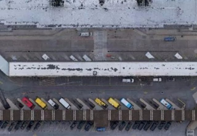
One day last month in Atlanta, drones made seven flights at the world’s busiest airport with the blessing of the Federal Aviation Administration (FAA). Those flights at Hartsfield-Jackson International Airport — the first civilian drone flights given FAA approval in a Class B airspace, a designation given the busiest area around crowded airports — marked a milestone for the development of commercial drones.
The flights on Jan. 10 helped map plans for two new parking garages and for moving a public-transit station, which are part of $6 billion in expansion and improvement program. Architectural designers at Autodesk said drones flown by 3D Robotics helped measure and plan the project much faster than standard measurements.
Experts say the approval indicates that as the drone market matures, the FAA is more willing to consider broader applications for the new technology.
“It’s a very big deal,” said Jim Williams, a principal at Dentons law firm. Williams, who previously led the FAA’s drone program in the Unmanned Aircraft Systems Integration Office, said the FAA-approved airport flights are “a very good sign that the FAA is taking everything on its merits and looking hard to find a way to make things work.”
The FAA set comprehensive regulations for drone operations in August. The broad rules allow flights during the day within sight of the pilot up to 400 feet off the ground, but generally not near airports or over crowds of people. That meant the drone operators who wanted to use the devices to map the airport needed a waiver from the FAA.
That waiver was one of more than 300 that FAA has granted for commercial drone flights since the regulations took effect. FAA has granted special permission for CNN to experiment with flights over people for news gathering, and with BNSF Railway to inspect tracks farther away than the pilot can see.
The industry wants the FAA to develop more rules to avoid the need for such case-by-case reviews.
Already real estate and photography businesses use drones frequently. The construction market also sees expansive uses for drones. The investment firm Goldman Sachs estimated in January that businesses will invest $13 billion in commercial drones by 2020, with more than $11 billion in the construction industry. “That’s creating a market that is too big to ignore,” a Goldman Sachs report said.
Williams, the former FAA official, said the construction industry was among the first to adopt drones for dangerous tasks before they were technically legal.
“They would fly the inexpensive drones because it’s so much easier to do,” Williams said. “It’s so much easier to inspect the outside of a building using a drone than it is to hang somebody on a harness to look at the outside of the building.”
At the Atlanta airport, Autodesk, a design, engineering and construction software company, wanted to use the remote-controlled aircraft to help design and plan part of the complex construction project at the airport, said Tristan Randall, strategic projects executive for Autodesk.
The airport wanted to keep the existing garages operating while the new garages were under construction, so the designers needed to look at the whole picture of the airport. Drones could provide precise measurements down to millimeters in a matter of hours, rather than over days or weeks that typical design work requires, Randall said.
“It’s a pretty amazing capability of being able to – within a couple of hours – get a complete 3D model of these existing buildings and then plan construction in the same environment,” Randall said. “We’re really excited to see where this technology can go.”
But the FAA set stricter drone rules than usual at the busy Atlanta airport, which hosted 104 million passengers last year, to avoid collisions with passenger planes or crashes that could hurt people on the ground.
To use the drones for the construction project, the FAA required 3D Robotics, the company whose pilot actually flew the drones, to have someone with a pilot’s license steer the drones so that he would have experience speaking with controllers. Commercial drone pilots typically just need to pass a knowledge-based test. Three observers watched the drones from the ground to ensure they were flying along the planned routes.
The FAA put a 200-foot ceiling on the drones to avoid conflicts with airliners higher aloft. Randall said drones hovered about 150 feet in the air to measure parking garages that were about 60 to 70 feet tall from above and to the side.
The pilot kept in communication with air-traffic controllers in the airport tower for each of the 15-minute flights, to avoid conflicts with passenger planes that might have needed to fly an unusual path after an aborted landing.
The drones flew mostly along automated paths, but could have been directed by the pilot’s tablet. The aircraft didn’t lose connection with the pilot, but were programmed to return to one of the four points where they had launched. The pilot also could have recalled the drones to their launch point with the press of a button, Randall said.
“I think the safety features that we have in place have shown that this is something we could do on any construction site,” Randall said. “We’re really comfortable with how the operations went.” “I think it’s really just the beginning of what we can do in this industry,” he said.
Photo: A picture of Atlanta’s Hartsfield-Jackson International Airport taken Jan. 10, 2017, bto help design construction – AUTODESK
Source: 11Alive Atlanta
Improve your Aerial Photography with these handy tips
droneblog.com
By Omar
February 16, 2017

Drones or unmanned aerial vehicles have literally exploded onto the market. Ok, well not like the Ford Kuga or the Galaxy 7, but you know what I mean, in a good way. They are affordable, fairly easy to get the hang of and loads of fun.
Many people are quite content to use their drone for a bit of fun, flying them around and doing the odd trick or two. Most people, however, want to take aerial photographs or video using their drones. This takes a bit of skill and a fair amount of practice. It’s not the same a snapping a quick selfie with your smartphone.
The first step is to master your drone flying skills. It is no good trying to take quality photographs if you are still worried about controlling the drone.
If you want to improve the quality of the photographs or video taken from your drone, read on. If you have some basic photography skills, great. The same ideas apply, they just have to be adapted for aerial photography. If you are an absolute beginner, that is also ok, the following tips will help you to take impressive drone photographs.
Practice
If you are just starting out, the urge to start taking photographs can be overwhelming. Try and fight this urge and ensure you can fly the drone perfectly before you add more challenges to the task.
Once you 100% confident and competent in operating your drone, you can start experimenting with photographs and video.
Also, keep an eye on the weather. This applies to beginners as well as experienced flyers. The more wind you have to contend with, the harder the task is going to be and the less likely you will be to get good results.
Camera quality
Much of this will depend on your budget and how seriously you want to take the photography aspect. Many drones come with a built-in camera, starting from rather basic and inexpensive to some pretty good quality cameras.
If you are still learning or taking the odd photographs as a hobby, the built-in cameras are fine. If you want to take it more seriously and produce high quality or commercial quality photographs, then it would be wise to go for a drone that you can attach the camera of your choice to. You might choose to start with a fairly basic camera and upgrade as your skills and needs develop.
A few things to look for in a camera:
Go for the highest megapixel count your budget will allow
The better the resolution, the clearer your photographs will be
Take a look at the view modes that are available to see what works best for you
Low-light capabilities are a great advantage
If you intend to shoot video as well as still images, the higher the frames per second the better quality your video will be
Invest in a Gimbal
A gimbal is a joint that mounts the camera onto the drone and assists in stabilizing the camera, compensating for the movement and keeping it steady as you shoot. Some drones with a built-in camera already have a gimbal. If you are adding your own camera, it is worth investing in a gimbal, especially if you want to shoot video.
They can be rather costly but if you have invested in a decent drone and a quality camera, it is worth spending the extra on a gimbal for better quality and clarity.
Most gimbals also allow you to move, tilt or angle the camera as well, allowing for a greater range of angles and options when shooting.
Go higher for more perspective
Many people try and fly close to the object they wish to photograph. While this might seem logical, it misses the main advantage of having a drone that can hover high above the subject, giving a great perspective and more into the picture.

Practice and experiment with different heights and angles to get an idea of what I am talking about.
Use GPS Mode
GPS mode can come in really handy, especially for less experienced flyers and photographers. The main advantage is that it improves stabilizations but it also allows you to focus on the photography without having to think much about controlling the UAV.
You can survey the area, pre-plan the flight path and then let the drone do its thing while you concentrate on taking the best shots.
Having a Drone with GPS mode is a most for Drone Photography. Unlike most RC craft, price is not a good measure of ease of use. If you take an RC car, for example, the more expensive models have more features and higher speeds and are more difficult to control. With drones or UAVs the slightly more expensive models are generally easier to control.
Use FPV
Some drones offer first person view or FPV as a standard feature, others work off an app or you might have to invest in additional equipment for this. FPV is particularly good for long range and distance shots or following a subject you are filming or photographing. It is not great for close up photography.
Get the Settings Right
This may take a bit pf practice and experimentation to determine what works best for your equipment and the type of work you are doing. Again, it takes practice and patience.
The drone and gimbal quality also make a big difference. Either way, it is very different than taking photographs from a camera on a sturdy tripod. What you sacrifice in stability your more than makeup for in the unique angles and perspectives that you can get from a drone.
With a decent gimbal you can use a lower resolution, play around to see what works best but 720p will normally be ok. Have the zoom on medium.
If you don’t have a gimbal use the highest resolution available and a wide zoom.
Getting this right will make a big difference to your results so take the time to experiment with different resolutions, frame rates and zoom settings.
Shoot Using Different Angles
The ability to take shots from a number of angles is one of the benefits drone photography offers so take advantage of it.
Get a series of multiple different angles and different viewpoints, from above and different sides. You can later determine which worked out the best.
Select a Good Location
Look for somewhere safe and open, free from overhead cables, birds, buildings and trees. You also want an area that has something or a few things of interest.
As you become more experienced you can try some more challenging locations.
Also, make sure it is legal to fly in the area you choose and you are complying with local regulations.
Night Photography
It helps to have a controller or app that gives you a display or FVP for night photography. You can buy additional lighting accessories that you can play around with for great effects.
Depending on what you go for you can take better shots at sunset or even in total darkness if the lights are powerful enough.
The main thing to bear in mind, especially if you are fairly new to photography is that most learning comes from practice and trial end error. You can read countless pages of tips and tricks but the real learning comes from doing it and analyzing the results. See where your errors are and decide what can be done to correct them. Works out what setting are best for what type of shot and setting. Always look at your photographs critically afterwards to see how they can be improved.
Decent photograph and video editing software is also essential to get professional results.
Trust me; it will not take long to be a competent aerial photographer. Once you have the basics mastered, you can fine-tune and perfect your skill and soon you will be taking captivating, incredible photographs.
By Omar
February 16, 2017

Drones or unmanned aerial vehicles have literally exploded onto the market. Ok, well not like the Ford Kuga or the Galaxy 7, but you know what I mean, in a good way. They are affordable, fairly easy to get the hang of and loads of fun.
Many people are quite content to use their drone for a bit of fun, flying them around and doing the odd trick or two. Most people, however, want to take aerial photographs or video using their drones. This takes a bit of skill and a fair amount of practice. It’s not the same a snapping a quick selfie with your smartphone.
The first step is to master your drone flying skills. It is no good trying to take quality photographs if you are still worried about controlling the drone.
If you want to improve the quality of the photographs or video taken from your drone, read on. If you have some basic photography skills, great. The same ideas apply, they just have to be adapted for aerial photography. If you are an absolute beginner, that is also ok, the following tips will help you to take impressive drone photographs.
Practice
If you are just starting out, the urge to start taking photographs can be overwhelming. Try and fight this urge and ensure you can fly the drone perfectly before you add more challenges to the task.
Once you 100% confident and competent in operating your drone, you can start experimenting with photographs and video.
Also, keep an eye on the weather. This applies to beginners as well as experienced flyers. The more wind you have to contend with, the harder the task is going to be and the less likely you will be to get good results.
Camera quality
Much of this will depend on your budget and how seriously you want to take the photography aspect. Many drones come with a built-in camera, starting from rather basic and inexpensive to some pretty good quality cameras.
If you are still learning or taking the odd photographs as a hobby, the built-in cameras are fine. If you want to take it more seriously and produce high quality or commercial quality photographs, then it would be wise to go for a drone that you can attach the camera of your choice to. You might choose to start with a fairly basic camera and upgrade as your skills and needs develop.
A few things to look for in a camera:
Go for the highest megapixel count your budget will allow
The better the resolution, the clearer your photographs will be
Take a look at the view modes that are available to see what works best for you
Low-light capabilities are a great advantage
If you intend to shoot video as well as still images, the higher the frames per second the better quality your video will be
Invest in a Gimbal
A gimbal is a joint that mounts the camera onto the drone and assists in stabilizing the camera, compensating for the movement and keeping it steady as you shoot. Some drones with a built-in camera already have a gimbal. If you are adding your own camera, it is worth investing in a gimbal, especially if you want to shoot video.
They can be rather costly but if you have invested in a decent drone and a quality camera, it is worth spending the extra on a gimbal for better quality and clarity.
Most gimbals also allow you to move, tilt or angle the camera as well, allowing for a greater range of angles and options when shooting.
Go higher for more perspective
Many people try and fly close to the object they wish to photograph. While this might seem logical, it misses the main advantage of having a drone that can hover high above the subject, giving a great perspective and more into the picture.
Practice and experiment with different heights and angles to get an idea of what I am talking about.
Use GPS Mode
GPS mode can come in really handy, especially for less experienced flyers and photographers. The main advantage is that it improves stabilizations but it also allows you to focus on the photography without having to think much about controlling the UAV.
You can survey the area, pre-plan the flight path and then let the drone do its thing while you concentrate on taking the best shots.
Having a Drone with GPS mode is a most for Drone Photography. Unlike most RC craft, price is not a good measure of ease of use. If you take an RC car, for example, the more expensive models have more features and higher speeds and are more difficult to control. With drones or UAVs the slightly more expensive models are generally easier to control.
Use FPV
Some drones offer first person view or FPV as a standard feature, others work off an app or you might have to invest in additional equipment for this. FPV is particularly good for long range and distance shots or following a subject you are filming or photographing. It is not great for close up photography.
Get the Settings Right
This may take a bit pf practice and experimentation to determine what works best for your equipment and the type of work you are doing. Again, it takes practice and patience.
The drone and gimbal quality also make a big difference. Either way, it is very different than taking photographs from a camera on a sturdy tripod. What you sacrifice in stability your more than makeup for in the unique angles and perspectives that you can get from a drone.
With a decent gimbal you can use a lower resolution, play around to see what works best but 720p will normally be ok. Have the zoom on medium.
If you don’t have a gimbal use the highest resolution available and a wide zoom.
Getting this right will make a big difference to your results so take the time to experiment with different resolutions, frame rates and zoom settings.
Shoot Using Different Angles
The ability to take shots from a number of angles is one of the benefits drone photography offers so take advantage of it.
Get a series of multiple different angles and different viewpoints, from above and different sides. You can later determine which worked out the best.
Select a Good Location
Look for somewhere safe and open, free from overhead cables, birds, buildings and trees. You also want an area that has something or a few things of interest.
As you become more experienced you can try some more challenging locations.
Also, make sure it is legal to fly in the area you choose and you are complying with local regulations.
Night Photography
It helps to have a controller or app that gives you a display or FVP for night photography. You can buy additional lighting accessories that you can play around with for great effects.
Depending on what you go for you can take better shots at sunset or even in total darkness if the lights are powerful enough.
The main thing to bear in mind, especially if you are fairly new to photography is that most learning comes from practice and trial end error. You can read countless pages of tips and tricks but the real learning comes from doing it and analyzing the results. See where your errors are and decide what can be done to correct them. Works out what setting are best for what type of shot and setting. Always look at your photographs critically afterwards to see how they can be improved.
Decent photograph and video editing software is also essential to get professional results.
Trust me; it will not take long to be a competent aerial photographer. Once you have the basics mastered, you can fine-tune and perfect your skill and soon you will be taking captivating, incredible photographs.
Read more:
Nominees Announced for 2017 NYC Drone Film Festival
World-class event to be held at the Skirball Center for the Performing Arts and Liberty Science Center March 17 - 19, 2017
droneblog.com
By Droneblog Editor
February 16, 2017
NEW YORK, NY, Feb. 15, 2017 — Nominations have been announced for the 2017 New York City Drone Film Festival, the world’s first and largest film festival dedicated to works filmed by drones. The complete list of nominees can be found below.
The festival, with headline sponsors RED and Freefly Systems, will be held March 17-19, 2017 at the Skirball Center for the Performing Arts and the Liberty Science Center. Tickets are available by visiting www.nycdronefilmfestival.com.
“This year’s films not only dazzle the senses with their beautiful imagery and high-flying acrobatics,” said Randy Scott Slavin, founder and festival director. “They take us to far-away places, examine social issues like climate change and the Dakota Pipeline, and riff on pop culture. One of them even features a team of drones making a cake. With films originating everywhere from the ocean to the desert to the skate park, the 2017 festival is our most diverse one yet.”
“Drone camerawork has already attained new realms of astonishment,” said David Pogue, founder of Yahoo Tech. “What’s so cool about the New York City Drone Film Festival is that it culls the best of that brilliance, and presents to the world the best of the best. I thought I’d seen it all. I was wrong.”
Awards will be presented in 13 categories including Best Narrative Film, Best News/Documentary Film, Best Extreme Sports Film, and Best Dronie, a selfie taken with a drone.
A series of master classes focused on various aspects of drone filmmaking taught by industry leaders has also been announced. Visit www.nycdronefilmfestival.com for the schedule.
2017 NYC Drone Film Festival Nominees
NARRATIVE
Drone Star Wars
Corridor Digital (USA)
The Mountain Within
Philippe Woodtli (Switzerland)
Rendez-vous
Yan Giroux (Canada)
X-FACTOR
Mixed Motion Project
Ilko Iliev and Marin Kafedjiiski (Bulgaria)
Caos en la ciudad
Roberto Hernández (Mexico)
Balance
Tim Sessler (USA)
NEWS/DOCUMENTARY
#NoDAPL: Drones Monitor North Dakota Police
Shadi Rahimi (USA)
Manabi 7.8
Juan Fernando Rojas (Ecuador)
Beauty & Bounty
Doug Armknecht (USA)
LANDSCAPE
An Aerial Perspective of Nordland
Michael Fletcher (Australia)
Perspective
Jay Worsley (USA)
Australia
Caspar Mazzotti (Australia)
EXTREME SPORTS
Moon Line
Frédéric Rousseau (France)
Sessions
Eric Sterman (USA)
Cala d’en Serra – Drone Parkour
Giles Campbell Longley and Kie Willis (United Kingdom)
Doonies 3: A Drone’s Eye View
Jake Yubeta (USA)
FREESTYLE/FPV
Drone Free Style
Rafael Paiva (USA)
Stone Eagle’s Flight
Gabriel Kocher (Switzerland)
One Night in Atlanta
Johnny Schaer (USA)
Fresh Squeeze
Robert McIntosh (USA)
ARCHITECTURE
Byzantine
Joris Favraud (France)
Dizi
David Etienne Durivage (Canada)
From Inside to Outside
Stephane Aboudaram (France)
FEATURING DRONES
Drone Cake Baking
Lucas Zanotto (Norway)
Light in Motion
Daniel Riley and Henning Sandstrom (USA)
Dron’t You Love Me?
Madeleine Dudley (Australia)
DRONIE
Cape Town Dronie
Matthew Wade (USA)
A Man (Almost Two) and a Dog
Mauro Pagliai (Italy)
Family Island
Florian Fischer (Germany)
SHOWREEL
Skynamic Pilot Reel 2017
Skynamic (Germany)
KopterCam 2017 Showreel
Koptercam (Finland)
ThisIsTilt Showreel 2017
Tilt (Norway)
STILL PHOTOGRAPHY
Climate Change Claims a Lake and an Identity
Josh Haner/The New York Times (USA)
Kim on the Rocks
Karim Iliya (USA)
Lost in Foliage
Dirk Dallas (USA)
Sea and Salt
Wellington Rodrigues (Germany)
The Tree of Life
Michael Bishop (USA)
Drone Runner
Gerard Juarez (USA)
About the NYC Drone Film Festival
The NYC Drone Film Festival is the world’s first and largest event exclusively dedicated to celebrating the art of drone cinema. The festival provides a platform for aerial filmmakers to showcase their work, shot anywhere in the world, emphasizing innovative storytelling, flight technique and aesthetic beauty. The festival offers an international platform for filmmakers from every corner of the globe to exhibit their work in front of industry professionals and the drone cinema fan community.
Read more:
Subscribe to:
Posts (Atom)