Tuesday, January 31, 2017

Beyond Visual Line of Sight Operations: The Next Target for FAA Regulation


expouav.com
By Juan Plaza
January 30, 2017


One key element of the FAA’s strategy for 2017 is finding consensus on a rule to extend commercial operations over populated areas and controlled airspace beyond visual line of sight (BVLOS) of the operator of the UAV. It’s something they are and will be looking at in order to determine regulation that makes sense for the entire drone industry.

A couple of weeks ago Administrator Huerta, during his speech at CES, emphasized the fact that his agency was beginning to work on draft regulation to issues rules for BVLOS operations. Two of the main elements that need to converge for this important milestone to be crossed involve new detection and avoidance technology as well as testing. There are a variety of tests that will need to take place to ensure flying a drone in this manner is both safe and reliable.

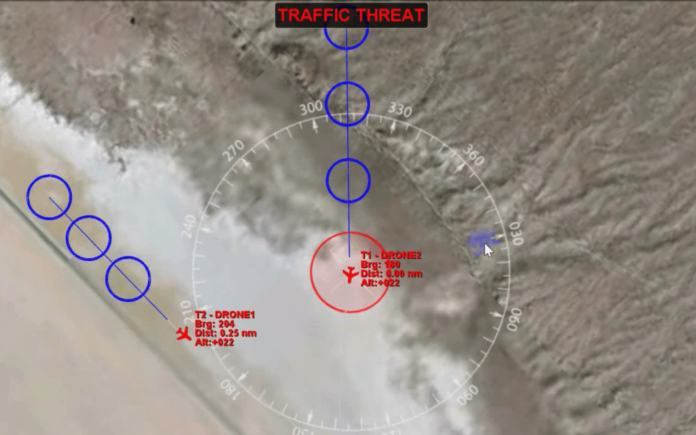
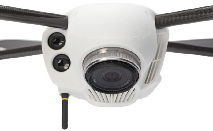
In regards to early detection and avoidance systems, companies such as Aerotenna are partnering with NASA and other industry leaders in the development and safe deployment of microwave-based, 360o technologies that are constantly prying the drone environment and not only its flight path. This innovation allows every drone in the airspace to be constantly “aware” of any other moving vehicle in its environment. It’s the kind of assurance that the FAA will need in order to draft regulations allowing BVLOS in controlled airspace.

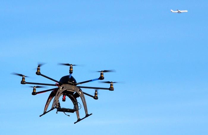
The second element that needs to take place in order for BVLOS to be considered safe is testing. These tests would have to be conducted in safe but realistic environments in order to assure the authorities that whatever results are obtained in the test sites can be safely and predictably applied to real flying environments.

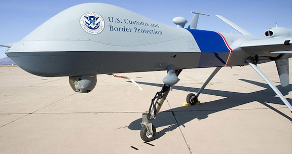
On December 28th the Federal Aviation Administration (FAA) approved a certificate of authorization (COA) for the Northern Plains UAS Test Site in North Dakota to be the first in the U.S. to have BVLOS operability. This means the test site will be able to support the development, testing and evaluation of a wide range of new applications for UAS technology.

Companies such as General Atomics and Northrop Grumman are tenants at the Grand Sky technology park, which means they can now evaluate complex UAS operations. It’s something that’s not possible anywhere else in the USA. Other companies are also applying to move into the facility and begin their own testing of new hardware and software aimed at making BVLOS a reality.

The Northern Plains UAS Test Site is ideally located to support beyond-line-of-sight operations, with the combination of an FAA test site, the Grand Sky Technology Park and the Grand Forks Air Force Base, which is home to an upgraded DASR-11 digital radar system.

With the opening of the North Dakota test site, the efforts of private companies to develop new safety technology and the willingness of the FAA to integrate the airspace, it’s only a matter of time before the UAV industry receive the good news that BVLOS has joined the growing number of flying techniques that can be used to apply drone advantages to more and more applications.


Read more:

Poynter Announces Groundbreaking Training Initiative on Drone Journalism

The Drone News
January 31, 2017


The innovative program, in partnership with Google News Lab, features workshops with The Drone Journalism Lab at the University of Nebraska, the National Press Photographers Association and DJI.


The Poynter Institute, Google News Lab, Drone Journalism Lab, National Press Photographers Association and DJI have unveiled an innovative program to train journalists in using drones, or unmanned aerial systems, for their news coverage. The program, which features hands-on workshops and online teaching, is powered by the Google News Lab.

Hands-on workshops, offered from March to August at universities from coast to coast, will offer training on safe drone operations as well as information that drone pilots need to study for the Federal Aviation Administration’s new Part 107 Drone Pilot’s Certificate. In addition, the three-day workshops will focus on the legal and ethical issues of drone journalism, community best practices and coordinated operations in a breaking news environment, as well as explore ways drone photography can be used in innovative storytelling.


“As a certified drone pilot myself, I know how difficult the exam can be for people who have no other pilot training,” said Poynter’s Al Tompkins, who is organizing the workshops. “Our goal is not to make you ‘test-ready’ but to show you what will be on the exam and to give you the fundamental knowledge you will need to study for the test.”

“We’re dedicated to supporting journalists’ experimentation with new technology,” said Erica Anderson of Google News Lab. “Drones present an opportunity for journalists to tell stories in visually rich and immersive ways, but there are still many open questions on how to apply them safely, ethically and creatively for news reporting. We couldn’t be more pleased to partner with The Poynter Institute on the drone journalism program to help tackle these challenges.”

Poynter will be leading these workshops in partnership with the Drone Journalism Lab at the University of Nebraska, the National Press Photographers Association (NPPA), the Google News Lab and DJI. Additional online training will be available later this year via Poynter’s e-learning platform, News University.

“Drones are purpose-built context machines. They can, in less time and at vastly reduced costs, give a viewer an understanding of the scale and scope of a story unlike anything else journalists have in the toolbox,” said the Drone Journalism Lab’s Matt Waite, who has become a leading voice for drone journalism through his work at the University of Nebraska. “Just getting a drone straight up 100 feet in the air has the power to change our understanding of how big, how far, how wide, how massive something is. And it can be done safely and for very little cost.”

The workshops also will include NPPA’s legal counsel Mickey H. Osterreicher, who has worked for years speaking on behalf of journalists as the federal government drafted regulations for where and when drone journalists could fly.

“NPPA has been at the forefront in advocating for the use of drones for newsgathering. With that opportunity comes an inherent role of operating them in a legal, safe and responsible manner,” Osterreicher said. “The legal landscape is especially complex because state and local governments increasingly are imposing their own restrictions on drone flights.”

The program also will feature hands-on introductory flight training sponsored by DJI, the global leader in drone technology and 2016 winner of NPPA’s Lemen award for technology innovation in photojournalism. “We are thrilled to join with Poynter to empower journalists with state-of-the-art technology that inspires innovative storytelling,” said DJI policy lead Jon Resnick.

Four universities are serving as hosts and partners for these workshops: the University of Georgia Grady College of Journalism and Mass Communication, March 17-19; Syracuse University Newhouse School of Public Communications, April 21-23; University of Wisconsin-Madison School of Journalism and Mass Communication, June 16-18; and the University of Oregon School of Journalism and Communication in Portland, Aug. 18-20.

In addition, the Google News Lab will support a limited number of travel scholarships for members of the National Association of Black Journalists, the National Association of Hispanic Journalists, the Asian American Journalists Association, Native American Journalists Association and NLGJA, the Association of LGBTQ journalists.

Participation at each hands-on workshop will be limited to the first 60 people to register. Workshop details are available at http://about.poynter.org/training/in-person/drones-17.

About Google News Lab
Google’s mission is to organize the world’s information and make it universally accessible and useful. Google created the News Lab to support the creation and distribution of the information that keeps people informed about what’s happening in the world today—quality journalism. Today’s news organizations and media entrepreneurs are inventing new ways to discover, create and distribute news content—and Google News Lab is here to provide tools, data and programs designed to help.

About the Drone Journalism Lab at the University of Nebraska
The College of Journalism and Mass Communications at the University of Nebraska-Lincoln established the Drone Journalism Lab in November 2011 as part of a broad digital journalism and innovation strategy. Journalism is evolving rapidly, and journalism education must evolve with it, teaching new tools and storytelling strategies while remaining true to the core principles and ethics of journalism. The lab was started by Professor Matt Waite as a way to explore how drones could be used for reporting.

About the National Press Photographers Association
The National Press Photographers Association (NPPA) is the leading voice advocating for the rights of visual journalists today. As the voice of visual journalists since 1946, NPPA has led the fight to promote and protect integrity and excellence in visual journalism. Its code of ethics stands for the highest integrity in visual storytelling. Its advocacy efforts put NPPA in the center of today’s thorniest issues in support of journalists throughout the country, while its educational initiatives seek to prepare visual journalists to meet the challenges of the profession. In light of these challenges, the work of NPPA has never been more vital than it is today.

About DJI
Founded in 2006, DJI is a global industry leader in high performance and easy-to-use aerial camera systems for recreational and commercial use. DJI products empower people of all skill levels to take to the skies and capture images that were once out of their reach. The company places heavy emphasis on R&D and innovation, and is committed to bringing aerial photography and videography to all. DJI currently has business operations in the United States, Europe, Japan, Hong Kong and mainland China.

About The Poynter Institute
The Poynter Institute for Media Studies is a global leader in journalism education and a strategy center that stands for uncompromising excellence in journalism, media and 21st century public discourse. Poynter faculty teach seminars and workshops at the Institute in St. Petersburg, Fla., and at conferences and organizational sites around the world. Its e-learning division, News University, www.newsu.org, offers the world’s largest online journalism curriculum in 7 languages, with more than 400 interactive courses and 330,000 registered users in more than 200 countries. The Institute’s website, www.poynter.org, produces 24-hour coverage of news about media, ethics, technology, the business of news and the trends that currently define and redefine journalism news reporting. The world’s top journalists and media innovators come to Poynter to learn and teach new generations of reporters, storytellers, media inventors, designers, visual journalists, documentarians and broadcast producers, and to build public awareness about journalism, media, the First Amendment and protected discourse that serves democracy and the public good.

Contact: Tina Dyakon
Director of Advertising and Marketing
The Poynter Institute
tdyakon@poynter.org
727-553-4343


SOURCE The Poynter Institute
Related Links

http://www.poynter.org


Read more:
http://thedronenews.com/2017/01/31/poynter-announces-groundbreaking-training-initiative-on-drone-journalism/

Amazon Patents In-Flight Transformer Drones

uasvision.com
January 31, 2017


Amazon.com has patented technology for drones with retractable in-flight wings. Amazon originally filed for the patent in October 2014 under the name “in-flight reconfigurable hybrid unmanned aerial vehicle.” The hybrid foldable-wing design is covered in a patent that was published last Tuesday.


The patent filing shows several types of hybrid drones whose wings can collapse for vertical takeoff and extend during horizontal flight to generate upward lift like a conventional airplane.

When the drone takes off, the robo-plane’s jointed wings would be folded around to provide a stable base for a vertical takeoff, with the rotors spinning in a horizontal plane.

But once the drone gets up in the air, the wings and tail would stretch out to create an airplane-style configuration. The rotors would then be spinning in a vertical plane, like a traditional airplane’s propellers, to push the drone forward.

When it’s time to land, the drone’s wings and tail would fold up again for a vertical landing. In their filing, Amazon’s inventors compare the craft to a Bell Boeing V-22 Osprey military aircraft, which tilts its rotors from vertical to horizontal, depending on whether it’s taking off or moving ahead.

Here’s one view of the drone transformation from straight-wing to folded-wing configuration. (Amazon Illustration via USPTO)

These diagrams show how the same drone can look quite different in folded-up vs. unfolded-wing configurations. (Amazon Illustration via USPTO)

The system could be well-suited for Amazon’s delivery drones, which have to lift off with packages weighing up to 5 pounds and then fly away horizontally at speeds of up to 50 mph to make deliveries within a half-hour.

The top diagram illustrates how the foldable-wing drone transitions from takeoff to horizontal flight, and then to landing. (Amazon Illustration via USPTO)

Source: Geek Wire


Read more:
http://www.uasvision.com/2017/01/31/amazon-patents-in-flight-transformer-drones/#more-48076

Pilot Spots Drone Flying 12,000 Feet Above Mumbai

uasvision.com
January 31, 2017


The pilot of a GoAir aircraft, approaching to land at Mumbai airport on Saturday morning, spotted a drone flying at an altitude of 12,000 feet. The white drone reportedly had four rotors and was flying at a horizontal distance of about two kilometres from the aircraft.
While there have been at least three sightings of flying objects in the past two years by pilots and airport ground staff, it’s the first time that an object has been spotted at such a height.


The incident took place when the A-320 aircraft operating flight G8-141 from Nagpur was on a descent to land in Mumbai airport. “The pilot was surprised to see the drone with rotors flying at such a height,” said a source. A GoAir spokesperson confirmed the sighting and added the airline informed the air traffic control (ATC) about the “flying object”.

The airline hasn’t filed a police complaint. The Mumbai ATC couldn’t be reached for a comment. O P Singh, director-general, CISF said: “We have been informed by the ATC and requested other stakeholders to investigate.”

Though drone flying is banned in India, the prohibition is rarely enforced. Drones are widely used for photography during weddings and other events. Last April, the International Air Transport Association (IATA), a global airline body, revealed aviation safety authorities worldwide had reported a significant number of near-collisions with unmanned objects. IATA said hazards involving manned and unmanned aircraft operating together in the same airspace require education of the drone operators.

The Indian aviation regulatory body, the Directorate General of Civil Aviation (DGCA) had called for a ban on drones till relevant rules were put in place. Last year, it released draft guidelines that dictated all unmanned aircraft intended to be operated in India will require a ‘unique identification number’ issued by the DGCA. It also mandated ground training for remote pilots, who should be not less than 18 years of age.

“Irrespective of weight category, the unmanned aircraft systems operator shall intimate local administration, air traffic service unit, airport operator and the Bureau of Civil Aviation Security before commencement and after termination of operation. In the event of cancellation of operations, the operator shall notify the same to all appropriate authorities as soon as possible,” the draft said.

Source: India Times

Read more:
http://www.uasvision.com/2017/01/31/pilot-spots-drone-flying-12000-feet-above-mumbai/

AUVSI XPONENTIAL Announces Conference Program

uasvision.com
January 31, 2017


The Association for Unmanned Vehicle Systems International (AUVSI) has announced the conference program for the upcoming AUVSI XPONENTIAL 2017, the largest trade show for the unmanned systems and robotics industry. As the regulatory environment has evolved to open up new opportunities, speakers from government, industry and academia will participate in more than 200 presentations and panel discussions addressing the potential for drones, robotics, and other unmanned systems. XPONENTIAL 2017 will take place at the Kay Bailey Hutchinson Convention Center in Dallas from May 8 to 11, 2017.

Among the program’s participants are thought leaders from government agencies, such as the U.S. Department of Defense, FAA, NASA, NOAA; and commercial organizations, including AT&T, AirMap, Barrick Gold, General Electric, Great Southwestern Construction, Intel, Johns Hopkins University Applied Physics Laboratory, Liquid Robotics, Northrop Grumman and Raytheon.

The industry opportunity has never been greater. For instance, the FAA expects that more than 600,000 unmanned aircraft systems could be flying for commercial purposes in 2017.

Speakers at XPONENTIAL 2017 will provide insight and actionable intelligence on the role of unmanned systems in a range of industries, including agriculture, construction, defense, energy, mapping, wireless, oil and gas, retail, and transportation, among others.

“Unmanned systems are transforming the enterprise,” said Brian Wynne, AUVSI president and CEO. “From energy and agriculture to broadcasting and security, unmanned systems, robotic and drone technology is enabling applications that were previously impossible. The educational program at XPONENTIAL is designed not only to showcase these advancements, but to provide attendees with real-world examples, best practices and smart strategies to leverage the power of unmanned systems in their own organizations.”

The conference program is divided into three tracks:
Policy: Airspace, local, state and federal government cooperation, international trade affecting unmanned systems, and regulation of unmanned maritime systems.
Technology: Defense technology innovation, drone delivery technology, protecting intellectual property, software development powering unmanned systems and automated vehicle technology development.
Business Solutions: Remote sensing, drones in the wireless industry, mapping and imaging, maritime applications for oil and gas, aviation risk management, and managing and protecting data.

The XPONENTIAL 2017 educational program will also include extensive technical sessions supported by white papers and a presentation series on government and defense opportunities for industry engagement. In the exhibit hall, education programs are planned for the Starting Point Theater, Solutions Theater and Poster Sessions area. There will also be special sessions, such as Women and Diversity in Robotics, and the Startup Showdown live pitch event, featuring new companies that are developing the future of innovation in the industry.

More than 7,000 industry leaders and professionals from more than 55 countries are expected to attend XPONENTIAL 2017. The exhibit hall will showcase more than 650 cutting-edge companies from around the world, representing more than 20 industries.

Registration for XPONENTIAL 2017 has opened. For more information click here.

Source: Press Release


Read more:

APB – Drones Meet Law Enforcement in Fox Crime Drama


dronelife.comBY MALEK MURISON
JANUARY 30, 2017


APB, a new crime drama launching on Fox later this month, offers an interesting and fairly realistic prediction of how drone technology could be applied in the world of law enforcement.

Gideon Reeves is a billionaire used to getting what he wants, when he wants it. That much is clear in a matter of minutes. He’s also the CEO of a leading technology company and knows a thing or two about drones. When a close friend is murdered in front of his eyes and the Chicago police are nowhere to be seen, he decides to take matters into his own hands. After publicly cornering the city’s mayor, he takes control of policing in Chicago’s struggling 13th district and digs deep into his own pockets to give the force a much-needed high-tech makeover. That’s where the drones come in.


Although the series starts with an exhibition of Reeves’ latest drone, designed to stem the flow of oil well fires and somehow capable of 36 hours of flight time, it’s when he makes the move into law enforcement that things get interesting. Plenty of drone enthusiasts and police men and women will enjoy the plausible look at how drones could be used to fight crime in the years to come.

Want to read about what’s really going on with drones in the world of law enforcement? Check out these articles:
3 Ways Police Are Using Drones Around the World
Will Taser Stun Drones Fly With Police?

Everything you’d expect from APB is present, along with a little of what you might not have considered before. Drones that look suspiciously similar to the DJI Inspire 1 are dispatched to keep track of perps’ on the run, while it’s not long before Reeves decides to arm them with tasers, too.

Drone fans will also enjoy seeing a prime-time tv version of a moment many pilots will have experienced: the dreaded loss of signal and the inevitable crash that follows.


APB, FOX’s new cop show with a twist, will be premiering on Monday, February 6th at 9pm ET/PT, and will continue to air on Mondays at the same time. It looks to be an entertaining series, especially if you’re into drones, arrogant but entertaining billionaires meddling where they shouldn’t, technology trends and generally looking forward at how UAVs can be applied to help make police work easier.


Read more:

Seven Ways to Use Drone Mapping on the Farm This Season

dronelife.comBY FRANK SCHROTH
JANUARY 31, 2017


Guest post by DroneDeploy

As one ag industry expert put it, using a drone on the farm is like being able to see your field from a 10,000-foot altitude, but also being able to zoom in to two inches above the plants. Growers are increasingly discovering that drone mapping is an invaluable tool, both for its ease of use, and for its many applications on the farm.


“It’s like being able to see your farm from a 10,000-foot altitude, but also being able to zoom in to two inches above the plants. There’s no other system that can do that.” — Rob Eggert, TDS fertilizer.

With the growing season fast approaching, we’ve put together a list of some of the most popular ways growers are using drones to improve their processes and make informed decisions about their crops.


1. Crop Scout to Detect Parasites and Fungi


Growers like Brent Gerke are using drone mapping to pinpoint plant health issues such as parasites and fungi. The very first time he used drone mapping software, Brent realized that by switching to the plant health map in his DroneDeploy dashboard, he could see areas of rust fungus in his wheat crop. Clear sections of red coloration on the map enabled him to quickly and easily identify the extent of the rust in the field.


Grower Brent Gerke’s plant health map helped him identify the extent of rust fungus in his wheat crop

Similarly, Tyler Smith in the Imperial Basin of California uses drone mapping to check alfalfa fields for dodder, a spaghetti-shaped parasitic plant that renders alfalfa seed virtually worthless. The only way to kill dodder is to burn it, so if a grower can catch it early, when the affected area is about the size of a table, they can contain the damage. Spotting such a small patch of dodder is difficult, but DroneDeploy’s plant health map allows growers to do just that.


“If you found a spot [of dodder] as big as the table, you could fix it right away as opposed to having it spread — big savings in terms of the amount of labor it would take to contain it.” — Tyler Smith


2. Compile Plant Counts

One of the most exciting uses for drone mapping in agriculture is the ability to conduct complete, accurate plant counts. Instead of relying on time-consuming manual counts taken on just a small portion of a field, growers like Toshiro Aoki are using drones to compile automated plant counts of entire fields in a matter of hours.

“The plant counting seals the deal. It saves us the trouble of having to go out and count the whole field.” -agriculture consultant Toshiro Aoki

Toshiro works for a private farm in Northern California. During last year’s growing season, hundreds of thousands of tomatoes plants were transplanted on a 74-acre field by an outside company. Toshiro wanted to make sure the company was billing them only for the established plants, so he used AgriSens, a third-party tool available right within the DroneDeploy dashboard, to quickly and easily get a plant count report that helped him hold the company accountable.


3. Analyze Stand Establishment


Aglytix provides corn and soybean growers with a detailed stand establishment report from within their DroneDeploy dashboards

In addition to plant counts, corn and soybean growers are using drone mapping to analyze stand establishment of newly planted crops to decide whether they need to replant certain areas. From the DroneDeploy dashboard, growers can send maps of their emergent fields to ag-focused analytics company Aglytix. The company uses the data to create a report that details crop emergence throughout an entire field, providing a far more comprehensive picture than on-the-ground sampling. The report also includes a stand establishment index and a calculation of the economic loss on the field.


4. Generate Variable Rate Prescriptions for Nitrogen and Pesticides

Ag expert Landon Oldham realizes that drone maps provide him with a rich amount of data that can be used to make more informed decisions about issues like crop reseeding and targeted nutrient applications. Growers can export their drone-generated, zoned shapefiles into Ag industry software to easily generate variable rate prescriptions for nitrogen, pesticides and other applications. He is taking this even one step further.

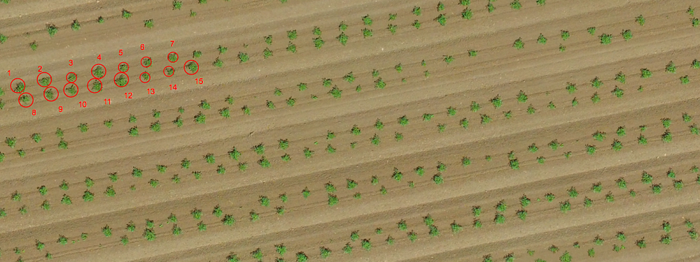
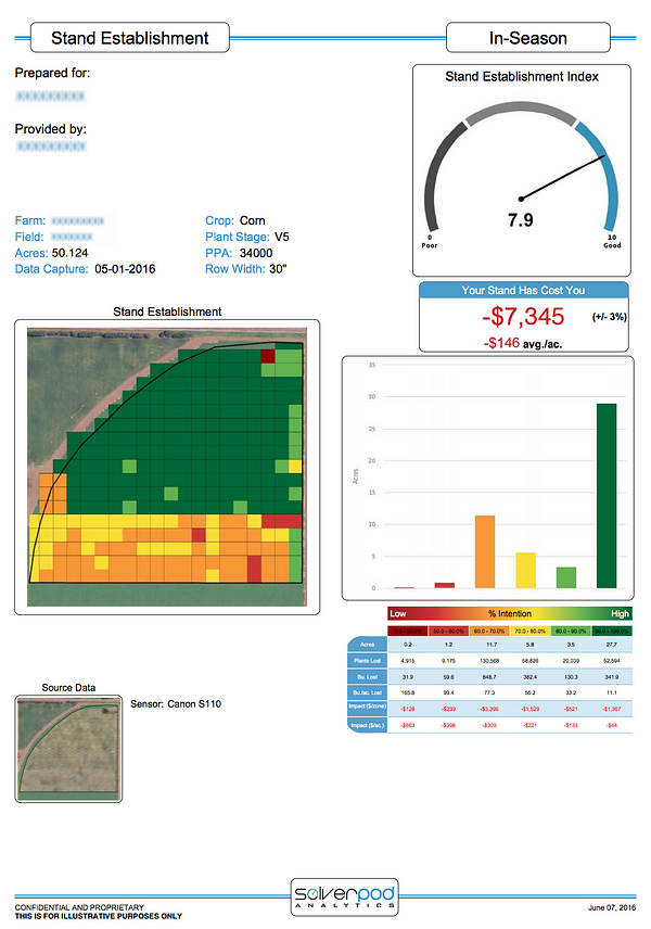
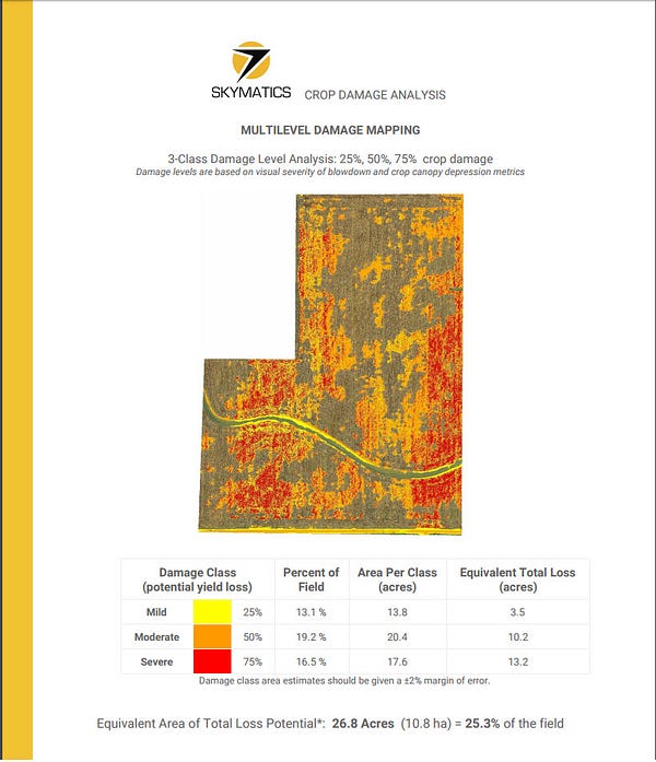
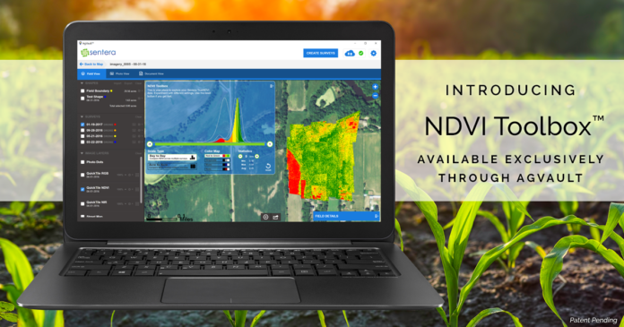
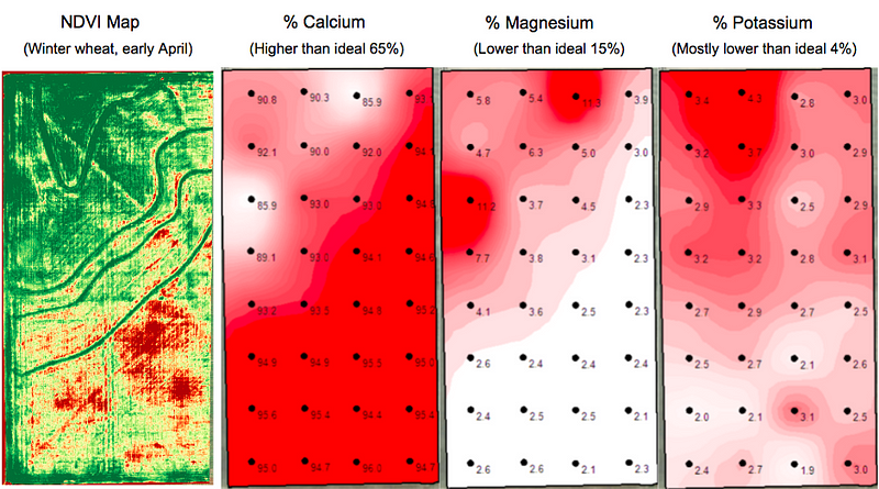
Drone map shows strong correlation to soil sample results, but with more detailed data

Landon owns Heartland Soil Services, a company that uses soil samples to estimate crop yields and make variable rate prescription maps. He is developing a workflow that combines drone imagery with soil samples to make even more accurate nutrient prescription maps. Instead of relying solely on data from soil samples — about one sample per two acres — Landon’s new workflow combines this sampling with the many data points on a drone-generated NDVI map to gather information at a much more granular level.


“The ROI could be tremendous because growers could further increase the site-specific application of any and all products rather than flat rate applying the entire field at the exact same rate.” — Landon Oldham, Heartland Soil Services


5. Assess and Clean-up Damage After a Storm


Jeremy generated a Skymatics crop damage report directly from his DroneDeploy dashboard

When heavy winds and exceptional rainfall downed corn on a 105-acre field in central Illinois, Jeremy Jones of Overhead Ag used DroneDeploy, paired with a detailed Skymatics report, to help the farmer and seed rep assess the extent of the damage. Instead of relying on traditional ground scouting, which could easily have missed catching large portions of downed crop, Jeremy used his drone to capture a complete picture of the field. Then, with just the click of a few buttons, he generated a detailed Skymatics crop damage report directly from his DroneDeploy dashboard.

The report included a calculation of crop loss and a categorized damage map that gave the farmer and seed rep a far greater understanding of the storm’s damage.


“It’s a nice, polished document that provides way more information on loss than I was getting by measuring certain areas.”- Jeremy Jones of Overhead Ag, on the Skymatics report he generated with his DroneDeploy map


Drone maps can not only help estimate the extent of damage, but in some cases can even help when clean-up is needed. When a tornado tore through his corn and soy fields, tossing debris throughout his crops, Brian Krukewitt made a drone map to spot debris hidden by standing corn and plan to efficiently remove it, whether before or during harvest.


6. Negotiate Fair Crop Loss Percentages


As every grower knows, crop loss is always a possibility — and that’s why many choose to insure their crops. But because insurance adjustors only have time to walk small sections of a damaged field, gaining an accurate picture of the loss can be difficult. This past summer, Gregg Heath of Silicon Falcon Micro Aviation used drone mapping to help a tobacco grower recover a fair loss percentage after heavy rains decimated nearly 100 acres of his crop.


“Drone Deploy is really tailor made for when you are surveying crops,” — Gregg Health of Silicon Falcon Micro Aviation. [click-to-tweet]

Gregg’s annotated crop health map, produced in just a few short hours, convinced an insurance inspector to re-inspect the field after an initial loss estimate fell short of expectations. Thanks to the detailed information provided by Gregg’s drone map, the adjustor took a second look at targeted areas and ultimately offered a far higher loss percentage. The grower ultimately recouped an additional $110,0000 in crop losses.


7. Assess Slope and Drainage After the Harvest

Although this year’s growing season is just beginning, it’s never too early to look ahead. Curt Moore at Agflyers reminds farmers that there are many uses for drone maps even after the harvest. “Once harvest is complete and post-season field prep is complete, you’re essentially left with a blank canvas,” says Curt. “Why not produce a map of your land in this state?”

With crop cover out of the way, Curt suggests using a drone-generated elevation map to get a sense of the slope and drainage of a field. Paired with DroneDeploy’s easy-to-use volume measurement tools, growers can plan the cut and fill of future terraces and waterways.


Orthomosaic map (left) and elevation map (right) of a terraced field. Areas in red are higher, areas in blue are lower.

Some growers, like Sam Meeker, take this one step farther, by comparing maps of their drainage systems — in Sam’s case, a map of bare dirt where tile lines are clearly visible — to their yield maps to evaluate the effectiveness of new tiling and decide whether to invest in additional drainage tiles.

Regardless of the crop or region, growers who integrate drones into their work quickly realize that they are easy to use and offer many possibilities. This coming season, growers will continue to use drone mapping to make life on the farm more streamlined, efficient and informed.


Where to Learn More

Thinking about bringing drone mapping to your farm? Be sure to read Seven Common Questions about Drones in Agriculture. For even more tips on using drone mapping in agriculture, check out our webinar, Lessons from the Field, with ag experts Chad Colby and Jim Love.

And as always, take a look at our ag-specific support documentation, such as:
Using Third-Party Plant Count Tools in Your DroneDeploy Dashboard
Onboarding for Agriculture
Understanding NDVI


Read more:
http://dronelife.com/2017/01/31/seven-ways-use-drone-mapping-farm-season/

Coast Guard Conducts small Unmanned Aircraft System Testing On Cutter Stratton

suasnews.com
By Press
30 January 2017


The Coast Guard completed system operational verification testing of a small unmanned aircraft system (sUAS) on Coast Guard Cutter Stratton, a national security cutter (NSC) based in Alameda, California, Jan. 2.

The Stratton crew and UAS program officials tested the power, communications, and launch and recovery systems that make up the sUAS to ensure that all parts functioned as needed and to identify areas requiring improvement. The full system consists of the aircraft, a ground control station, and a forward and an aft directional antenna, which contain the necessary fiber optic cables needed to communicate with the aircraft. Installation of the system components was completed Dec. 23; testing began a week later.

The testing prepared the Coast Guard for the sUAS deployment on Stratton planned for this winter, data from which will help the service assess how to make the most of sUAS capabilities on patrol while minimising risk. The initial deployment will use ScanEagle sUAS capability obtained through a June 2016 order on a pre-existing multiple-award contract executed by the Naval Air Systems Command. The Coast Guard will use the deployment data to refine the concept of operations and requirements for installing and integrating future systems across the NSC class. These requirements will inform a request for proposal for sUAS for NSC capability, planned for release by the end of fiscal year 2017. The contract award for the retrofit of Stratton and one additional NSC is targeted for fiscal year 2018.

The service is also looking into the possibility of integrating sUAS into other cutter operations. Lessons learned from the integration of sUAS capability on the NSCs will guide future procurement of systems on other cutter classes. “The upcoming deployment is going to inform the sUAS for NSC strategy, and the eventual sUAS for NSC solution is going to inform the Coast Guard’s long-term sUAS strategy,” said Jeff Bishop, UAS program manager.


The acquisition of sUAS for the NSCs is in the Analyze/Select phase, which involves establishing operational requirements, evaluating acquisition approaches and assessing the merits of each approach. The Coast Guard is pursuing the sUAS acquisition to provide persistent, tactical airborne intelligence, surveillance and reconnaissance to enhance the cutters’ effectiveness.


Read more at:

Saturday, January 28, 2017

Compressor Bearing Failure Led to 2015 Reaper Crash

uasvision.com
27 January 2017


On 18 November 2015, at approximately 2338 Zulu (Z) an MQ-9A, tail number 08-4044, assigned to the 27th Special Operations Wing at Cannon Air Force Base (AFB), and deployed to Kandahar International Airport, crashed in an open field near the base after declaring an in-flight emergency (IFE) shortly after take-off. The Launch and Recovery Element mishap crew (MC), consisting of one mishap pilot (MP) and one mishap sensor operator (MSO), noticed high oil pressure, rising exhaust gas temperature, and fluctuating torque immediately upon take-off. The MC reported the IFE and attempted a recovery to the runway; however, complete engine failure occurred on the crosswind leg at approximately 500 feet above ground level. The mishap aircraft (MA) glided to a crash landing as the crew attempted to circle around to land.

The impact destroyed MA, four missiles, and one bomb, resulting in a loss valued at $14,391,950. There were no fatalities or damage to private property.

The Abbreviated Accident Investigation Board President found by a preponderance of the evidence the cause of the mishap to be a compressor bearing failure that led to engine loss. The Board President determined that the lack of an audible warning to indicate the high oil pressure associated with the bearing failure and the mishap crew’s task saturation significantly contributed to the mishap. Under 10 U.S.C. § 2254

The full report is available here.

Source: USAF


Read more:
http://www.uasvision.com/2017/01/27/compressor-bearing-failure-led-to-2015-reaper-crash/

Unifly Wins ‘Best Emerging Drone Company’ Award in the EU Drone Awards.

dronelife.comBY FRANK SCHROTH
JANUARY 27, 2017


On Tuesday January 24th, 2017 the first EU Drone Awards were presented at the European Parliament in Brussels. The EU Drone Awards are an organisation of the European Young Innovators Forum (EYIF) with the goal of boosting the European drone industry.

Out of 50 candidates from 14 countries 9 finalists were selected in 3 categories: Best Drone Manufacturer, Best Drone-based Application and Best Emerging Drone Company.

Unifly was presented with the award of Best Emerging Drone Company. This category awards the most attractive European emerging company taking into account market potential, impact of the solution, team, European dimension and technological innovation.


Unifly was very honoured to receive the Best Emerging Drone Company award. We see it as recognition of everything we have achieved so far and as extra motivation to continue on the chosen path.

The EU Drone Awards are a great way to put innovations and new developments in the drone industry in the spotlight and give young entrepreneurs a well-deserved boost.

Marc Kegelaers – CEO Unifly

Other award winners include the following:
Special Innovation Prize: Drone Based Solution — Airbus Defence and Space
Certificate of the Best Drone Based Solution — Clear Flight Solutions
Certificate of Best Drone Manufacturer — microdrones


Read more:
http://dronelife.com/2017/01/27/unifly-wins-best-emerging-drone-company-award-eu-drone-awards/

Sentera Offers NDVI Toolbox Crop Health Maps Showing Field Contrast & Progression

suasnews.com
By Press
26 January 2017


Sentera today announced the release of its NDVI Toolbox™ for AgVault™: a set of tools for customizable Normalized Difference Vegetation Index (NDVI) data that give growers and agronomists significant insight into field and crop health, today and throughout the season. Users can recolor, dynamically regenerate, and highlight areas of an NDVI Crop Health Map, on data gathered today, and on historical data. The NDVI Toolbox is now a standard feature of Sentera’s AgVault™ Software Pro and Viewer licenses.

“Until now, you needed to choose between viewing data tailored for NDVI progression over time, or tailored for NDVI contrast around a single flight – but, you couldn’t do both,” said Greg Emerick, executive vice president for Sentera. “We changed that. Now, growers and agronomists have that flexibility. They are more in control of their operations, and can make even better decisions, even faster.”


Why this matters


NDVI essentially compares one area to another, illustrated with colour. If a crop is generally healthy, it appears bright green on an NDVI map. This is generalised data, however, and is only useful in general terms. AgVault’s NDVI Toolbox makes that data actionable by building flexibility into the colour map. Instead of blanketing an NDVI map with low variation of a single colour, the NDVI Toolbox allows you to force dramatic colour variations to show a plant’s health relative to others in the field at a granular level.
Fly once, and areas of concern can be zoomed in on in AgVault, and assigned a wider variation in colour value for easier analysis; the average person can identify areas of stress, compaction or drown-outs. Fly multiple times, and see problem areas as they emerge. Perpetual problem areas can be investigated and remedied effectively – even going back to previous flights to see when issues emerged. Or re-analyzing data from the past in different ways.


“Every time you fly an NDVI sensor and collect data, AgVault catalogues the data and the NDVI Toolbox becomes more robust, offering more accurate data,” remarked Reid Plumbo, director of product management for Sentera, “It just gets better and better.”

AgVault’s NDVI Toolbox features two viewing options:

Day to Day – Growers can monitor and compare a field over time, highlighting changes from one day to the next. The Day-to-Day view ensures growers can pinpoint areas that have flourished or become stressed over time and take action. Multiple data sets build on one another.

Acre to Acre – Allows growers to determine the overall vigor of a field, identify problems, and take action. This is all completed with a single data set.

“Our customers have been asking for this exact solution, and we’re honored to have brought this answer to the precision ag industry,” said Plumbo.
The NDVI Toolbox is available now with Sentera’s AgVault™ Software Pro and Viewer license options.
For more information on Sentera’s NDVI Toolbox capability, visit: https://sentera.com/agvault-software/#ndvi-toolbox
Patent pending.


About Sentera
With more than 220 years of combined experience with sensors, software, UAV, data management, and engineering solutions, Sentera is a leading designer, developer, and manufacturer of remote-sensing technologies in the agriculture, infrastructure, and public safety industries. In a single growing season, Sentera’s equipment gathered over 175 terabytes of data from 8,000 flights. The company recently passed a milestone of collecting more than 25,000,000 acres of images. For more information, visit www.sentera.com.


Read more:

Vigilant Aerospace Completes Beyond Line-of-Sight UAS Detect-and-Avoid Flight Testing at NASA Armstrong

suasnews.com
By Press
27 January 2017


Vigilant Aerospace has completed successful beyond lineof-sight flight testing of its new FlightHorizon detect-and-avoid collision avoidance system for unmanned aircraft at NASA Armstrong Flight Research Center in Edwards, California. The tests demonstrated the system’s ability to provide beyond line-of-sight flight safety for both small and mid-sized unmanned aircraft to help comply with FAA regulations and integrate drones into the national airspace.

The flights tested the system’s detect-and-avoid (DAA) algorithms, hardware integration and user interface performance and included nearly 100 scripted encounters between unmanned aircraft under realistic flight conditions. The system successfully detected and tracked intruder aircraft and provided traffic alerts and collision warnings on 100% of air traffic during the encounters.

Eighteen different scenarios were flown multiple times using two DJI Phantom 4 drones with one aircraft acting as the primary ownship while the other acted as an intruder aircraft. The scenarios triggered the system’s traffic alerts, threat alerts and collision warnings, allowing the drone pilots to avoid collisions between the aircraft. The encounters included beyond line-of-sight flights that simulated real-world scenarios in which visual detection of approaching aircraft by ground-based unmanned pilots might not be possible due to distance, weather, altitude and speed.

The tests were observed by the FAA’s senior UAV regulator, by an FCC observer to monitor radio transmissions, and were the culmination of a multi-month program of development, safety planning and test preparation, concluding in December, 2016.


Vigilant Aerospace has exclusively licensed the NASA patent and software which forms the basis for the company’s FlightHorizon product and was invented by Dr. Ricardo Arteaga at NASA Armstrong. A significant advantage of the FlightHorizon system is that it utilizes off-the-shelf hardware, uses the existing national air-traffic control system and can be used on both smaller and larger UAVs.

The detect-and-avoid system is an important part of the effort to integrate unmanned aircraft into the national airspace and to make beyond line-of-sight drones safe to share airspace with manned aircraft. FlightHorizon is designed to comply with FAA drone regulations on beyond line-of-sight flight, night flying and airspace authorization including Part 107.200 waiver requirements and RTCA SC-228 operating standards. All transponder data was logged in FlightHorizon and is being used by NASA and Vigilant Aerospace to continue to improve and add new features to the system.

About Vigilant Aerospace Systems – Vigilant Aerospace Systems, Inc. is a provider of industry-leading next-generation flight management and safety systems to provide situational awareness, synthetic cockpit views, collision avoidance and other flight information to enable integration of commercial drones into the national airspace. For more information, visit www.VigilantAerospace.com


Read more:
https://www.suasnews.com/2017/01/vigilant-aerospace-completes-beyond-line-sight-uas-detect-avoid-flight-testing-nasa-armstrong/

Thursday, January 26, 2017

Dutch drone start-up nominated for international drone price

The Drone News
January 26, 2017


The Dutch start-up Avy has been selected from more than a thousand contestants as a finalist in the international drone competition ‘Drones for good’ in Dubai. The competition selects the best drone and drone-applications with a humanitarian purpose. The winner receives a price of 1 million dollars.

Avy has developed a rescue drone for refugees in need travelling across the Mediterranean Sea. The drone is capable of flying long distances, can detect boats and – if necessary – drop life jackets, food and medicine. In the past year 3.500 refugees died during this dangerous endeavour. Avy aims to reduce this number drastically.

‘Drones for good’ is organized by the Dubai ICT-fund and Dubai Telecom and aims at stimulating the development of innovative drones for a better world. Of all the entries, 10 international finalists have been selected to compete in the competition which takes place on the 17th and 18th of February in Dubai.

Avy will launch their drone, the Avy One, on the 2nd of February in the Amstelkerk in Amsterdam.


Read more:

Veronte Autopilot for Parcel Delivery

uasvision.com
January 26, 2017


The integration of Veronte Autopilot in drones for parcel delivery permits to define routes from an intuitive interface. To reach the delivery spot, just, select a point on the map and the system will automatically draw an optimized route. To maximize flight safety, Veronte Autopilot includes: transponder compatibility, predefined obstacles avoidance, collaborative sense and avoid, flight termination system…

Veronte Autopilot includes modules for advanced performance: multiple spot delivery, satellite & 4G communications,… adaptive control is also a must, these algorithms permits to automatically adjust the flight control for changing flight & mass conditions.
Platforms

Veronte Autopilot is compatible with any unmanned system, by using the same software and hardware. It can be configured via software for controlling any unmanned platforms: UAS, RPAS, Drone, USV / ASV, UGV…

Fully autonomous aircraft control from take-off to landing, compatible with any platform configuration: VTOL, flaperons, elevons, custom tail (V, X, T, H…), control w/o ailerons, hybrid…

Standard flight phase database including: take-off (catapult, hand launch, runway, airdrop…), climbing, loiter, waypoint route, hover, hold, descending, landing (runway, net, deep-stall, flare, moving platforms, linear landing…), flare… and user customizable phases for any aircraft behavior customization, user configurable up to PID level.
User interface

Veronte Pipe team has developed a highly intuitive control station tool that permits to configure a customized environment to operate. This application permits to control any Veronte based platform using the same interface, from a PC / Tablet running Windows, Linux or MAC.

This easy to use tool permits to operate the system with no pilot training. Configurable layout permits to load custom background maps (Google, Bing, Yahoo… or user images), and telemetry displays can be placed as desired on the screen.

Mission definition tool has been designed as an on map drawing tool for intuitive path design. On Veronte Pipe, not only waypoints can be defined but also custom links between waypoints, relative waypoints to a moving object, obstacle definition, no go areas… being possible to edit it during the flight.

Source: Website


Read more:

Restrictions on Use of UAVs in US Antarctic Program


uasvision.com
January 26, 2017


Due to the potential operational, environmental and safety hazards posed to Antarctic activities by the operation of Unmanned Aerial Vehicles (UAVs), the use of any UAV, drone, or remotely piloted aircraft in Antarctica by U.S. Antarctic Program (USAP) personnel is prohibited without specific authorization from the National Science Foundation (NSF) . This prohibition includes the operation of commercially available or custom designed „quad copters”, remote controlled camera systems, and any other unmanned airborne systems.

The point of contact for approved use requests is:

Mr. Mike Scheuermann
Aviation Program Manager
Division of Polar Programs
mscheuer@nsf.gov
Phone: 703.292.7453

A formal policy will be developed in the near future which will outline the process for acceptable use of UAVs for research and/or operational purposes.

Source: Press Release


Read more:
http://www.uasvision.com/2017/01/26/restrictions-on-use-of-uavs-in-us-antarctic-program/

How to Choose a High Quality Camera Drone

droneblog.com
By Michael Karp
January 25, 2017


Camera drones come in all shapes and sizes. These days, you can get cameras on extremely small micro drones, racing drones, and all the way up to expensive octocopters.

But when you’re looking for quality, there are a few attributes you should pay attention to. These attributes define the difference between a quality camera drone and one that’s simply for recreation.

Let’s break them down:

Camera Quality

When you’re researching camera drones, pay attention to the camera’s quality.

Many camera drones come with a camera that shoots video in 4K resolution. This is more than good enough. You will also find a lot of cameras that can take 10-12 megapixel still photos.

These two features are quickly becoming a staple in the drone world, but if the camera shoots video in a little less than 4K and/or takes a little less than 10-12MP stills, you still have a pretty good camera on your hands.

Next, find out if the camera built-in, if can you switch it out, or if you need to buy one separately.

What you want will depend on your goals and the equipment you already have. Most camera drones come with a built-in camera that’s pretty powerful, but some photographers and videographers like to use their own equipment.

Finally, figure out if you can attach filters to the camera. This could drastically broaden the type of shots you can get.

In-Flight Camera Adjustment

It’s a big plus if the drone allows you to adjust your camera’s setting mid-flight. This can save you a lot of time, because you won’t need to land every time you want to change settings or re-adjust the camera.

Look for drones that allow you to adjust the camera’s angle and basic settings, at a minimum. Then see if you can adjust exposure, focus, and other more advanced settings from the ground, as well.

Reviewing Footage

When camera drones first came out, you had to shoot all of your footage and download it to a computer before you could review it and see what types of shots you were getting.

Today, you can find models that allow you to review your footage directly from the controller or a mobile device. This is a huge time-saver, and it lets you get the shots you’re looking for faster.

Flight Time

Drone flight times typically range from 8 minutes up to 30 minutes.

Flight time on the lower-end drones (like the models under $100) isn’t crucially important. These models are more for having fun, and their batteries usually recharge in 30-45 minutes and you’re back in the air again.

For professional pilots and more serious photographers/videographers, flight time is a big deal. It means you have more time in the air to get your shots, and you need less replacement batteries to extend your sessions.

Go for a drone with a flight time of at least 18 minutes. If you can get into the 22+ minute range, you should be golden.

Autonomous Flight Modes

Autonomous flight modes are excellent features to have at your disposal. They allow you to get expert quality shots without having to control the drone manually.

Here are a few examples:

Follow Me – The drone automatically follows you and captures what you’re doing.

Course Lock – Lets you fly in a set direction.

Waypoints – Let’ you set multiple GPS points for the drone to fly between, while you control the camera.

Home Lock – Fix your controls to be relative to the Home Point.

Point of Interest – Set a specific point for the drone to orbit around.

Journey Mode – The drone flies out away from you to capture a selfie.

Return Home – With push of a button, the drone returns to you.

These types of flight modes can make it a lot easier to maneuver your drone and get amazing aerial shots.

Control Distance

Control distance refers to the distance between your controller and the drone before it loses signal.

It’s an important characteristic, because it tells you how far away you can fly your drone before losing control of it.

You want this distance to be as long as possible (to be safe), but anything around 1500 meters or more should be fine. Most higher-end camera drones have a more than long enough control distance.

FPV Capability

Next, FPV (first person view) capability is a huge advantage when taking aerial photos and videos. You can see what your camera sees in real time, so you can make sure you’re getting the most accurate shots possible.

Find a camera drone that can relay a live FPV feed to a screen on the controller or to a mobile device.

Obstacle Avoidance

Finally, this isn’t a must-have, but it’s definitely helpful:


Obstacle avoidance.

This feature gives your drone the ability to bounce away from any object that comes in its path. This includes both manual flight and automated flight.

If you tend to fly in obstacle-rich areas (lots of trees or buildings) obstacle avoidance can come in handy.

Over to You

As long as you keep these attributes in mind, you should be able to find a quality camera drone to meet your needs.


Read more:

Kespry Announces Drone 2 with increased performance

suasnews.com
By Press
25 January 2017


Kespry, the leading aerial intelligence platform provider, today announced that it has enhanced the Kespry Drone 2 with higher performance features that deliver significantly greater accuracy and reliability.

These enhancements make Kespry Drone 2 even more ideal for a wide range of industrial applications, including those requiring survey-grade precision, such as in mining and the architecture, engineering and construction (A/E/C) markets. The new Drone 2 now achieves four to six times the accuracy of the previous Kespry Drone System.


“Customers are looking for a complete drone solution that provides survey grade accuracy, without sacrificing speed and convenience,” said George Mathew, CEO and chairman of Kespry. “ The enhancements to the Kespry Drone 2 – bringing centimeter-level accuracy – exemplify how Kespry is innovating the industrial drone space through its Aerial Intelligence Platform.”

By adding a high-performance ground receiver, the Kespry Drone 2s can deliver accuracy of two to 10 centimetres. The Global Navigation Satellite System (GNSS) base station receiver serves as a single survey control point. During a flight, imagery from the Drone 2s and data from the base station are collected simultaneously. Both data sets are automatically uploaded for processing in the Kespry Cloud where accurate survey-grade data is automatically generated.


Such degrees of accuracy are critical for mine planning, determining boundary lines, positioning underground utility cables and pipes, and other survey-grade applications. The single ground control point simplifies survey applications as it eliminates the need for multiple control points and additional manual measurements in the survey process.

“When we started working with the Kespry Drone System about a year ago, we were trying to find ways to be more efficient,” said Murry Cline, vice president of operations with APAC-Central, Inc. “We can now fly our Kespry Drone 2 over our entire 60-acre aggregate site in about 15 minutes. Previously, it would have taken us about a day or a day-and-a-half to do the inventories and a few more days to do the calculations.”

Post-Processed Kinematic (PPK) technology is used to increase the accuracy of photogrammetric aerial images. Integrating PPK improves the speed, efficiency and reliability of gathering survey-ready data in commercial and industrial environments.

“We’re ready to take the Kespry system to the next level, go beyond calculating inventories using the drones for things like mine planning and other applications that will give us an even greater business advantage,” Cline said.

The enhanced Kespry Drone 2 and Drone 2s are available now and are already being used by a range of customers like APAC-Central, a subsidiary of Oldcastle Materials, Inc., an industry leader in asphalt and concrete pavement construction, materials and services.

http://kespry.com/products/kespry-drone

TAGS
Kespry Drone 2

CBP Regulatory curve ball could drastically slow drone industry.

suasnews.com
By Paul Aitken
26 January 2017


Customs and Border Protection (CBP) may change import duty and classification for DJI and other drones currently imported as toys watch out for Aerial Photography Aircraft (Unmanned)

Last year, (2016) was often called the year of the drone by many reporters, tech advocates and news agencies. Many small drone service companies took off the ground, mid-size businesses augmented existing services, and even corporations are now looking to get in the drone game. However, large companies haven’t quite jumped into the market with both feet… yet. That may all change in February when DJI announces a new industrial drone, the DJI Airworks program, and a strategy for exponential growth.

I have my doubts, all because of a possible regulatory curve ball that could drastically slow down the drone industry.

Many industry advocates understand that in order for the drone industry to retain exponential growth, more industries need to jump on the drone train. The roadblock to many industries’ ability to embrace this technology is that they are unable to acquire data that is precise enough to make a liability based decision. This precision is called regulatory grade data and has been previously written about by Patrick Egan. DJI is also aware of the regulatory grade data issue.


This may explain why we saw the unveiling of the Phantom 4 Pro, so quickly after the release of the phantom 4.

The Phantom 4 Pro’s sensor comes close to providing the resolution necessary for regulatory grade data, but we’re not there yet. DJI are continuing to pursue industrial and corporate entities by unveiling DJI Airworks. This program is designed to take their aerial platforms beyond just photography and videography, and into the realm of regulatory grade data collection.

But many people have asked the question, why such a push for regulatory data from DJI? Is it really to garnish more sales, or to create strategic alliances with corporate America?

Whether we’re talking about regulatory grade data, or Real Estate videography, in the eyes of many the FAA is still far behind in creating a viable system that allows for economic development using drones. I recently wrote about this particular issue here.

The emotional connection that drone pilots experience from an aerial perspective has put the FAA in a very interesting position. Why? Because in the U.S. there are currently more registered drones than registered manned aircraft.

Yet sales numbers show that the number of registered drones represent just of a quarter of drones sold. The FAA seems to be behind the regulatory curve, and many operators ignore the “rules” with a perception of immunity.

So how will the FAA retain the authority and credibility over the drone industry that seems uncontrollable? By pulling the proverbial carpet out from under the industry.

How could the FAA pull out the rug from under this industry? Actually, what they can do isn’t the issue, it’s who they consult with that raises the possibility of a problem.

Consider this scenario for a moment. If you’re the FAA, who can you recruit to assist in slowing down an industry you feel you’re losing control over? You can recruit Customs and Border Protection (CBP). CBP is the Federal Agency tasked with controlling what is imported and exported into our country.

Currently, since drones are categorised as toy aircraft, DJI pays no duty tax on importing drones into the United states, with the potentiality of a 15% parcel tax.


Suppose CBP were to change the categorization of the drones imported into the US?

What if CBP created a special categorization for drones? No longer would be the days of Duty Free import to the United States. If CBP were to change drone categorizations, it has the potential to instantly slow down and massively complicate the drone industry.

Will this actually happen, or is it purely speculatory? Only time will tell if this is a reality for the drone industry.

If this change of categorization happens, it could increase the cost per unit for imported drones quite a bit. It would move a DJI Phantom from the toy aircraft category into the Aerial Photography Aircraft (Unmanned), a newly minted classification. This potential change in duty taxes (again, 0%) would cost foreign drone makers (like DJI) just enough in duty fees to make the sales of their product taper off.

So help combat this, it makes sense for DJI to go after those markets that in the past have been hesitant to embrace this technology. With the inclusion of those markets, not only would DJI potentially increase their market share, they would have instant access to the lobbying machines currently in place from those industries.

By creating a drone capable of collecting regulatory grade data, DJI is positioning themselves nicely to take advantage of both the markets themselves, and the political clout that is already in place. Getting those stakeholders on your side is instrumental is continuing to ride the wave that is the burgeoning drone market. And with DJI’s Airworks, that wave doesn’t look to break yet.


Read more:

Tuesday, January 24, 2017

Why Your Disaster Kit Should Include a Drone

Why Your Disaster Kit Should Include a Drone

The Red Cross agrees: The life your sUA saves may b

The Red Cross agrees: The life your sUAS saves may be your own.


inverse.com

Bryan Kelly
October 14, 2015


Along with fresh water, canned food and that dubiously useful aluminum-foil blanket, drones could become a crucial part of your personal emergency preparedness kit.

This assumes, though, that authorities continue to allow the use of small unmanned aerial systems (sUAS) in disaster areas in the coming years.

In California, drone use was said to have interfered with local firefighters’ efforts to abate wildfires, leading the state’s legislature to pass a bill restricting non-commercial drone use over disaster areas — a bill that California governor Jerry Brown vetoed, saying it went too far.

Elsewhere, in Texas, after flooding in Austin endangered the lives of several residents, drones were said by some first responders to have interfered with rescue operations.

But on the flipside, one civilian’s use of a drone to identify the location of four stranded people was credited with saving their lives.


A similar story was reported from Nepal, where drones were an integral part of relief efforts to victims of a devastating earthquake.

It’s a fascinating question of means vs. ends: Are drones a pinnacle example of “situational help in a time of need,” a term coined in “The Unmanned Helping Hand”, an article on drones published in Homeland Security Today. Or do those in trouble wind up worse off, thanks to the interference of drones?

One organization particularly well-acquainted with saving lives has an answer. The American Red Cross, in conjunction with other agencies, recently released a 52-page report exploring the viability of drones at surveilling difficult areas during disaster scenarios.

Among the policy recommendations in that report:

Develop an emergency course of action for private sector and non-profit organizations that would allow for the on-demand operation of drones post-disaster and issue blanket approval for locations in which these entities can fly.
Permit small and microUAS (unmanned aircraft systems) operations in controlled airspace within disaster areas.
Permit commercial small and microUAS operations over populated areas during declared emergencies.

We can take the Red Cross’s interest in sUAS as a sign the machines may help save lives. But given the chance to own one, should we take matters into our own hands? In disaster situations, drones can act as both information-gathering pseudo-helicopter and carrier pigeon. They can communicate the location of stranded survivors — especially if we are the survivors.

One issue complicating private drone ownership, and use, is existing regulation. At present, drone use is governed by the Federal Aviation Administration (FAA) Modernization and Reform Act. Amended in February 2015, this act sets restrictions on commercial drones, including only flying during daylight hours; setting a 500-foot flight ceiling; and mandating that drones remain within the line of sight of their operator.

Reform to this bill continues apace. In May of this year, two U.S. senators, Cory Booker and John Hoeven, introduced the Commercial UAS Modernization Act, which among other things gives the FAA flexibility to make changes in the rules governing drone use.

It behooves anyone concerned enough about natural disasters — i.e., those in flood plains or tornado alleys — to pay attention to the direction of private drone ownership and use regulations. Just owning one won’t be enough; it will serve better if you are skilled in its use, and can minimize the chance that your using it hurts organized relief efforts.

Playing within the rules is essential, even if, in a disaster scenario — say, a flood — when an individual is stranded, all legal bets will be off. For as it says in Revelations, a drone carrying a fig leaf back to the stranded survivors of the Second Great Flood will tell the world the waters have abated…

Or not.

Photos via wikimedia commons


Read more:

This dentist quit his day job to build a flying phone case drone Cheap, lightweight, and easy to put in your pocket

theverge.com
by Ben Popper
Jan 24, 2017


Hagay Klein has been an orthodontist in Israel for 10 years, but he would be happy never to see the inside of a patients mouth again. “I hated it,” he admitted recently, during a visit to The Verge’s office in New York. “I would work one day a week and spend the other six building things.”

Klein was big into model aircraft and spent months constructing an intricate marble clock. Eventually he was bitten by the drone bug, and came up with an idea for a drone he thinks anyone, no matter their comfort level with aircraft, would be happy to own.
THE THINNEST DRONE I’VE EVER SEEN

The Selfly drone is 9mm thick, and snaps into a phone case that fits onto the back of most modern smartphones. With the case on, you can still slide your phone in and out of most pockets, making it much simpler to always have an aerial camera on hand.

Like the Dobby drone we saw at CES, the Selfly can take off and land in the palm of your hand. It hovers in place and can be controlled by your phone. You can capture 8-megapixel stills and 1080p video at 30 frames per second. Its battery lasts about five minutes, which Klein believes should be enough for a night of selfies.

LIMITED BATTERY AND A LOW PRICE

The Selfly camera is not as nice as the one you find on Dobby or the Hover Cam, but it’s smaller than both those units (and at $99, it’s also several hundred dollars cheaper). I’m not convinced that selfie drones are actually a thing many consumers will want, but this is definitely the year we’ll find out, as there are lots of different approaches to this use case hitting the market.

The Selfly is available for preorder today on Kickstarter. As always, remember that mass-producing hardware is tough, so pledge at your own risk.