Wednesday, November 30, 2016

Fotokite Phi: The Tethered Camera Drone


dronelife.com
BY MALEK MURISON
November 29, 2016


Fotokite has launched a tethered camera drone, the Fotokite Phi. Like plenty of other consumer drones, the Phi is designed to carry a GoPro camera. But there the similarities end. This is a drone on a string. It’s tethered, just like a kite, and ticks plenty of boxes for new flyers.

If we go through some of the common problems faced by new drone pilots and aerial photographers, there are probably a few that all will agree on. Although it’s kind of the whole point, the biggest issue is probably the act of flying itself. Sure, the very latest consumer models can pretty much take care of that, but for plenty of pilots, the whole flying process can detract from the media side of things.

Another is the inevitable moment when your drone decides to ignore your controls and disappear into the distance – something that’s probably happened to the majority of pilots at some point. And what about the innate creepiness of camera drones, the sense of unaccountability that many people feel when they see a drone in the sky? Who’s controlling that thing..?

Fotokite has come up with a product that could solve some of these problems. This is the Fotokite Phi.


The Fotokite Phi is a tethered, foldable quadcopter designed for anyone who wants to capture a moment from a unique perspective, without the fuss of unpacking a drone or even learning how to fly one. The company has suggested that it’s as easy to fly as a kite, which will mean different things to different people. But we get the idea: it’s all about ease of use and simplicity.

The Phi os compatible with GoPro cameras (3/3+/4 and Hero5 Session), and is available for a limited time at a price of $249.

“The Fotokite Phi gives everybody the power to capture bird’s-eye footage as quickly and easily as possible,” said CEO Chris McCall. “There are a ton of problems with traditional airborne camera systems – lengthy setup time, flyaways, reliability on GPS signals, difficulty flying indoors – and we wanted to solve as many of them as possible. The Phi’s combination of portability, usability and safety makes it the perfect companion for anybody who wants to tell stories from the sky.”


After building a professional version for broadcast journalists, Fotokite launched asuccessful Indiegogo campaign last year, and the Fotokite Phi is now shipping and available to customers looking for a family-friendly and novel way to capture aerial footage.

Back in 2014, Fotokite founder Sergei Lupashin exhibited an early model of the idea on the Ted Talks stage:


“We’re aiming to create a new, fresh category in the flying camera lineup. The tether solves two big drone tech challenges – localization (where-am-I) and interaction (what-do-I-do) – in an intuitive way without requiring joysticks or a smartphone to control it. We’re incredibly excited to see folks use this device – and have fun while flying it – while on their adventures and travels.” – Fotokite founder and CTO Sergei Lupashin


A few of the Fotokite Phi’s features include:


Easy launch

To get your Phi off the ground, all you need to do is point it in the direction you want it to go and give it twist. Just don’t forget to hold onto the leash.


Gesture control

The Fotokite Phi essentially flies itself, but you can control its movement to a degree with simple gestures. Rather than relying on complicated joystick controls, the Fotokite uses the force of the tether to fly next to the user. Hold the yaw or orbit button on the leash and rotate your wrist – the Phi will follow your commands.


You will not lose this drone

Considering that there’s a physical connection between pilot and drone, this might go without saying. The tether makes a flyaway an impossibility. But just in case the tether is cut, the Phi will automatically begin a controlled descent and power off upon landing. Clever. The same will happen if the Phi is running low on battery during a flight.


Sharable, not like in the annoying social media way


How many drone pilots out there would feel comfortable handing over complete control during a flight to a five-year-old? Not many. But the Phi is different. It can be passed around and shared between friends just as you would with a kite.


Easy to get around

Weighing in at 14 ounces including a camera, this is comfortably the lightest GoPro-carrying quadcopter on the market. It also folds into a compact carrying case. The Fotokite Phi comes with up to 100 feet of leash and a removable battery. The battery gives around 13 minutes of flight time and charges directly through a USB port. Spares will soon be available for $24 – a bargain by industry battery standards.


Camera integration

The Fotokite Phi is best used with GoPro Hero 3/3+/4 cameras. These can be powered by the Phi and will automatically turn on when flying starts. Filming can be controlled directly from the Fotokite Phi leash (video start/stop, photo capture).


The price

Fotokite Phi is now shipping at the price of $249.


Fotokite Phi – Final thoughts

The Fotokite Phi is certainly an original entry into the drone market that will tick a lot of boxes for new pilots and young flyers. At under $250, it’s a great option if you’re looking for an easy to use GoPro compatible drone. However, we can’t yet vouch for the quality of the footage you’ll be able to achieve with it. It will depend on the GoPro camera that you choose to work with, as well as the light and wind conditions.

Having said that, we don’t get the impression that this has been designed as an aerial photography product for professionals. It’s more about the fun of a shared experience, and a way of capturing moments from above without being the creepy anonymous drone hovering overhead. It also looks super easy to use and simple to transport. For $250, what’s not to love?


Read more at:

http://dronelife.com/2016/11/29/fotokite-phi-tethered-kite-drone/

The TFR Over Standing Rock: What Law Enforcement Doesn’t Want You to See


dronelife.com
BY MIRIAM MCNABB
November 29, 2016


News and Commentary. The FAA has issued a Temporary Flight Restriction(TFR) over the Dakota Access Pipeline Protest, prohibiting any aircraft other than law enforcement from flying over the site for a 4-nautical mile radius. Regardless of the claim that the TFR is for “safety,” the effect of the TFR is to block any legitimate documentation of activities on either side: something that law enforcement – accused of using excessive force – would seem to have an active interest in preventing. But drone advocates – including drone law experts John Goglia in this week’s Forbes piece, and Peter Sachs in Drone Law Journal – ask a legitimate question: does the FAA have the right to prevent citizens from flying over any situation merely because it is potentially embarrassing to government forces?


Background: The #NoDAPL Protest


The Dakota Access Pipeline is an underground oil pipeline project of over 1,000 miles planned by Dakota Access, LLC, a subsidiary of Energy Transfer Partners. It begins in the Bakken oil fields in Northwest North Dakota and the proposed route runs southeast, through South Dakota and Iowa, to end in Illinois. The proposed route runs underneath the Missouri River half a mile from the Standing Rock Indian Reservation; any spill would impact the water supply for the tribe, as was documented by the EPA and Department of the Interior (DOI): however, the pipeline was granted an exemption from the environmental review required by the Clean Water Act and the National Environmental Policy Act by using a loophole in construction permitting.

In an effort to voice dissent to the pipeline, the Sacred Stone Camp was formed on April 1, 2016. Since then the protest camp has grown to include thousands of protesters. The response of law enforcement in attempts to clear the camp has escalated to include arrests, the recent use of water cannons trained on protestors in freezing temperatures, rubber bullets, and attack dogs. Law enforcement denies using excessive force; but bystander video of these situations certainly brings the government tactics into question, such as this video of the use of water cannons which clearly shows the water being trained on the people, rather than fires as law enforcement claims.


The FAA TFR: a “Terrible Precedent.”

The FAA has issued a TFR over Standing Rock, citing “law enforcement operations” as the reason for the TFR, as required by law. TFR’s are to be issued to “[p]rotect persons and property on the surface or in the air from a hazard associated with an incident on the surface.” But attorney Peter Sachs, a drone advocate and publisher of Drone Law Journal, says that “law enforcement operations” is a pretty broad definition of a “hazard” or safety issue – since the only safety issue would appear to be caused by the law enforcement operations themselves. In fact, the most significant effect of the TFR is not safety, but a media blackout; which Mr. Sachs describes as throwing “in essence, a ‘giant tarp’…over the site, allowing law enforcement to act with impunity and without any witnesses.” Mr. Sachs explains that there are 3 degrees of TFR that the FAA can use – some of which specifically allow media to fly. “They opted for the most restrictive one,” says Sachs, explaining that while there may be occasions when a TFR to support law enforcement and keep media out is necessary and indicated by law – such as the Boston Marathon bombing, or the 9/11 attacks – these examples are few and far between. “Largely, a TFR should not be issued if the purpose or effect is to infringe upon the 1st Amendment. This is a terrible precedent.”

The FAA responded to DRONELIFE’s inquiries with a statement rejecting the premise that the TFR effectively blocks out the media. The FAA says that media who meet their requirements are allowed to fly with permission:


The Federal Aviation Administration carefully considers requests from law enforcement and other entities before establishing Temporary Flight Restrictions (TFR) in U.S. airspace. The TFR currently over the pipeline protest was approved to ensure the safety of aircraft in support of law enforcement and the safety of people on the ground.
The TFR includes provisions for media to operate aircraft – both traditional and unmanned – inside the TFR, provided that operators comply with the language of the Notice to Airmen. In the case of unmanned aircraft, operators must also comply with the requirements of Part 107 and coordinate beforehand with the FAA. We’ve had no requests from media who meet those requirements.


The key to this statement may be “media who meet those requirements.” To date the only media outlet with an official drone program appears to be CNN: it’s unclear if any other news media, including local news, bloggers, or citizen journalists could possibly be granted permission. And as recent narratives such as the “Black Lives Matter” movement demonstrate, major news outlets generally only begin to cover a story when it has reached a critical mass in social media and the blogosphere.

The fact that the reports of what is actually taking place at Standing Rock differ depending upon who is reporting is the most significant argument for allowing drones, citizen and official alike. Like body cameras on police, drone footage should protect both sides from exaggeration or falsified accounts. Cora Peirce, a Native advocate and community leader in Wampanoag land preservation efforts, says that the drones allow people all over the world to make their own decisions about conditions at the Sacred Stone Camp. “This is the largest peaceful protest in our country’s history,” says Ms. Peirce. “It’s vitally important to see what’s going on for yourself.” She adds that reports of militarized action have been largely denied by local law enforcement, who have said, for example, that the water cannons clearly shown were simply a fire truck trying to put out fires. “The drone footage shows real events – and they are often in direct conflict with reports from law enforcement.”


Shooting Down Drones

Some of the feeling that the TFR is a deliberate attempt to prevent documentation is based on the fact that law enforcement has reportedly shot down 9 citizen and local media drones to date, which is a federal felony. These attacks have been documented by video also, as in the example posted below which clearly shows law enforcement taking aim at the drone.


While the incidents have been widely reported on social media, the only official complaints made to the FAA are those of law enforcement, who reported a citizen drone being flown “in a threatening manner.” The FAA responded to DRONELIFE’s request for comment on this issue with a standard statement issued to other journalists also:


Although the FAA is aware of anecdotal reports of drones being shot down, the agency has received only one official report. On Oct. 23, a drone was shot down with bean bags after allegedly being flown in a threatening manner near a law enforcement helicopter. That incident is still under investigation.
The agency also is investigating several incidents in which protestors have allegedly flown their drones in violation of the provisions of the TFR.


“Not Part of the FAA’s Mission.”

Regardless of opinions on whose drones are causing a safety hazard, drone expert John Goglia, writing for Forbes, says that the issue is clear: “Keeping the media from documenting law enforcement actions is not part of the FAA’s mission. Nor is it a legal basis for issuing flight restrictions.” Both Goglia and Sachs point out that the only other time a similar TFR was issued was over the protests against the police shooting of a black teenager in Ferguson. In that case, there is hard evidence that the purpose of the TFR was specifically to keep the media from reporting on the protest: transcripts obtained by the Associated Press of a recorded air traffic control line leave absolutely no doubt that the FAA cooperated in a deliberate media blackout.

The FAA is in a difficult position. They are responsible for the safety of the skies; they are a federally mandated agency. They must work with law enforcement and other agencies in emergencies and natural disasters. They are required to balance the needs of all aircraft requesting access to airspace. However, in clearly political situations, the FAA may find itself on the wrong side of history if it makes covering up embarrassing situations for law enforcement all over the country part of its job.


Read more at:
http://dronelife.com/2016/11/29/tfr-standing-rock-law-enforcement-hiding/

DJI MAVIC PRO – BLUSTERY DAY WIND TEST


thedronenews.com
November 30, 2016


More at:
http://thedronenews.com/2016/11/29/dji-mavic-pro-blustery-day-wind-test-part-deux/

PAPER AIRPLANE DRONE – POWERUP FPV – | VLOG0031


thedronenews.com
November 30, 2016


More at:
http://thedronenews.com/2016/11/30/paper-airplane-drone-powerup-fpv-vlog0031/

Drone Deploy DevOps Engineer / SRE


suasnews.com
By Press
29 November 2016


DroneDeploy is the leading cloud software platform for commercial drones, making the power of aerial data accessible and productive for everyone. Trusted by businesses and individuals in over 130 countries worldwide, we are transforming the way drone users collect, manage and digest impactful data in a variety of industries, including agriculture, real estate, mining and construction. Simple by design and easy to use, DroneDeploy builds revolutionary software compatible with any drone.

Drone technology has only just emerged from expensive toys into the realm of commercial application. Since time immemorial, the idea of agents with a bird’s eye view has been the dream of everyone from generals, farmers, surveyors, architects, and everyone in between. That dream has now become a young industry, and Dronedeploy is a leading SaaS provider making it happen. It is not an exaggeration to say this is your opportunity to experience history in the making. How often in a lifetime do you get a chance to say that? If you’re excited about drones and want to help us create a simple and seamless experience for drone users across the world, we’d love to hear from you!


The Challenge

The infrastructure team is tasked with keeping up with our accelerating growth without falling over. The platform we design and build enables high ROI decisions in industries as diverse as construction, agriculture, mining, conservation, forestry, and infrastructure inspection (but not military). We use a collection of SaaS, opensource, and proprietary technologies; whichever provides the right solution and seamless integrations for that piece of the puzzle. Some of the key technologies we leverage include Docker (for code packaging and deployment), Kubernetes (for container management), Ansible (for a lightweight config management), and Terraform (to manage our cloud infrastructure).


The Role

In this position you will be expected to:
Have a passion for managing complex systems using software
Bring a background in SRE, DevOps, System Engineer, etc.
Love extinguishing excessive complexity
Empathize with the people who use systems you build
Excel at critical thinking and adapt to new situations
Anticipate future problems, without over-engineering the present
Be an expert in your domain, but never stop learning new things

We are looking for someone with:
Minimum of 2 years experience managing complex systems using software
Experience using and maintaining configuration management systems (e.g. Ansible, Puppet, Chef, Salt, Terraform, CloudFormation)
Experience solving difficult problems with a scripting language (e.g. Bash, Ruby, Python) in a Linux environment
Proficiency writing and maintaining software programs

Bonus Points
Deep Docker expertise
Experience with Kubernetes/Mesos/CloudFoundry
Experience with major cloud providers (AWS, GCP, Azure, etc)


Life at DroneDeploy

Located in San Francisco’s growing SOMA district, we’re a team of star wars loving, hot sauce eating, tech enthusiasts with inspirational talents. Everyone is empowered to explore and implement new ideas and improvements. We enjoy our collaborative office environment and encourage each other to push boundaries. We host weekly Friday night BBQs on our rooftop deck, offer great salaries, generous equity,100% employee health coverage, unlimited vacation and delicious catered meals among other perks.


DroneDeploy is an equal opportunity employer.

At this time DroneDeploy will only consider applicants local to the SF Bay Area. If you are outside the locale and willing to relocate for this role, please note so in your cover letter. DroneDeploy will consider relocation assistance for the the right candidate.

Any unsolicited agency or recruiter submissions will be considered a gift, and we thank you.

https://boards.greenhouse.io/dronedeploy/jobs/488364?gh_src=05b41l1#.WD3DwLJ97iw


Read more at:
http://www.suasnews.com/2016/11/drone-deploy-devops-engineer-sre/

Deutsche Telekom Goes Drone Hunting with Dedrone


suasnews.com
By Press
30 November 2016


Leading European telco Deutsche Telekom AG is entering the drone defense market together with Dedrone, the market leader in anti-drone technology. Starting tomorrow, the Magenta Security business unit of Deutsche Telekom will offer protection against unauthorized drones for data centers, stadiums, critical infrastructure facilities, and public authorities utilizing solutions developed by Dedrone. Deutsche Telekom will provide all services – from sales, project planning, and installation through management of the system. Project prices start at 30,000 Euro. In the coming weeks, Deutsche Telekom will install Dedrone technology at two of its own properties to secure them against drone intrusions.


The need is clear. Drone popularity continues to rise rapidly as they become ever cheaper and more powerful. Easy availability and large payloads conspire to increase the potential for dangerous drone misuse – everything from industrial espionage to drug and weapon smuggling to terrorist attacks. Such imminent threat demands comprehensive countermeasures. “Over the last few months, Deutsche Telekom has extensively evaluated and thoroughly tested equipment from the most important manufacturers of drone detection and defense systems. We are bundling the best of the technologies under the control of lead partner Dedrone for our Magenta Drone Protection Shield,” explains Dirk Backofen, soon-to-be head of Telekom Security.


Complete System for Drone Protection
DroneTracker, developed by Dedrone in Kassel, is the key system that detects drones automatically by means of various sensors – such as video cameras, radio frequency scanners, and microphones – and repels them if necessary. At its core is smart software that is able to distinguish drones from birds, helicopters, and other flying objects safely, and even to recognize specific drone models.

DroneTracker is a modular system that can be integrated into customers‘ existing security systems. Open interfaces can be used to connect sensors from other manufacturers, including radar from Airbus or Robin Radar, Rohde & Schwarz radio frequency scanners, and Squarehead Technology microphone arrays. This flexibility allows design of optimal coverage for different areas and buildings.


As soon as DroneTracker detects a drone, it alerts security forces. They can immediately take protective measures and, for example, bring people to safety, seize drones or dropped objects, or block views of sensitive information. Where laws and regulations permit, jamming transmitters such as those from HP Wüst can be used to bring down the drone.


“Best Product on the Market”
“Cooperation with Deutsche Telekom is an important step for us,” says Dedrone COO Dr. Ingo Seebach. “The fact that we have been selected from a large number of well-known manufacturers shows not only that we are leading the way with our technology, but also that we have what it takes to earn a business relationship with such a large, highly respected company. That gives us tremendous leverage from a sales perspective. We are convinced that data centers in particular, as well as major event venues and industrial enterprises, must prioritize protecting themselves from drones. Together with Telekom, we are delivering the best product on the market.”


Read more at:
http://www.suasnews.com/2016/11/deutsche-telekom-goes-drone-hunting-dedrone/

Putting Drones to Work at a Global Firm: Insights from POWER Engineers


suasnews.com
By Press
30 November 2016


Rebecca Wilson

POWER Engineers is an engineering consulting firm specializing in the delivery of integrated solutions. Based in Idaho, with 40 locations across the United States, as well as an office in South Africa, POWER serves a wide range of projects, including facilities, infrastructure, environmental, and energy.

Early on, POWER realized the value that drones could add to their projects. And as a sophisticated consulting firm, they also understood the regulatory, insurance, internal, and client requirements they would need to meet in order to operate successfully.

A few weeks ago, I sat down with Aaron Ames, POWER’s department manager of Mapping and Analysis. Aaron shared lessons learned as well as advice for other engineering and construction firms looking to adopt drones. He also addressed some of the questions asked most frequently by Skyward friends and customers:

How do I make the case for drones to my executive team?
How do I choose which drones and software to invest in?
How do I scale my drone operations across multiple teams?
How do I track and manage everything?

Gaining buy-in for drones


Prepping for an eBee training


Several years ago, Aaron and his colleagues anticipated a market for aerial data among their clients.

“The bulk of our work is in high voltage transmission lines,” Aaron explained. “The analysts in my department collect GIS data for an area, look for opportunities and constraints, create impact assessments and models, and locate the least impactful route for a transmission line.”

Before investing in drones, POWER had to show that there would be a market for aerial data. At the time, this was a challenge because the technology was in its infancy.

“It was hard to show that this was a service that our customers would pay for,” Aaron said. “So we did some market analysis and were able to show our leadership that companies subcontract large manned aircraft for the same type of data collection. At POWER, we routinely do this for large projects. Often there are reroutes and changes in the development of a transmission line. In cases like this, deploying an airplane takes a lot of time and money. We saw that drones could be a viable alternative for smaller projects or collection areas. We expected that drones would allow us to fly, obtain data, and have information to our design team within the week.”

As with most mature companies and major corporations, there were also concerns around risks. “We had one group that viewed drones as too risky—cowboys flying without any oversight. Another group viewed it as a hobby aircraft.”

Aaron alleviated these concerns by showing that senseFly’s fixed-wing eBee has many built-in safety features, and because it’s very lightweight, the risk to transmission lines and other facilities is very small.
Lesson #1: Gain buy in by addressing safety concerns and showing how drones will be able to make money, save money, or both.


Meeting regulatory requirements


Like many small businesses and major corporations in the United States, POWER’s drone program was stymied by the FAA’s queue for 333 Exemptions.

“We sat in the 333 process for some time—about 9 months,” Aaron said. “At first, there was a lot of excitement: We had training flights, and colleagues started asking us to take on client projects. But we didn’t have the certification, so interest died pretty quickly.”


PRO TIP: MARKET YOUR DRONE PROGRAM INTERNALLY BY PRESENTING AT INTERNAL AND EXTERNAL MEETINGS AND CONFERENCES AND CONTRIBUTING ARTICLES TO YOUR COMPANY NEWSLETTER.

Since Part 107 took effect in August, POWER has had three pilots pass the FAA’s knowledge test and receive certification.

“Now we’re trying to get that excitement going again,” Aaron said. “We’ve presented at a few internal conferences and we’re adding UAS as an additional offering to our existing services.”
Lesson #2: Plan for delays as you meet requirements from regulators or your own internal legal and risk management team.


Investing in the right aircraft + software solution


Currently POWER uses senseFly eBee for terrain and orthophotography collection and DJI Inspire for videography. Aaron kindly shared the current technology stack that POWER uses to gather aerial data on transmission line projects.


At RDO’s conference for senseFly eBee pilots


senseFly ebee: “We use the eBee to collect hybrid solution aerial photography and terrain, as well as ground elevations to support design,” Aaron said. “RDO, one of the major senseFly distributors, recently had a conference and invited 12 of its biggest clients that use eBee aircraft. The most exciting part of the conference was having 10 eBee in the air at the same time. We mapped a square mile in seven minutes. It took a lot of coordination, but the system was able to handle it. We also talked about the different systems we’re using and how we’re processing data. Being part of an expert group specializing in survey grade data collection really extends my base of knowledge.”


PRO TIP: AN ACTIVE USER COMMUNITY FOR SOFTWARE AND AIRCRAFT CAN PROVIDE ADDED VALUE AND EXPERT GUIDANCE.

Pix4D: “We process our aerial data with Pix4D, which develops the image mosaic and terrain model. Flying the eBee is easy, collecting and processing the data is where you need to know what you are doing.”

ArcGIS and eMotion (senseFly’s GCS software):
“I develop the actual areas I’m flying using ArcGIS and eMotion, and I decide which areas I’ll fly, including resolution and overlap, using a combination of ArcGIS, Google Earth, and eMotion.”

Global Mapper:
“Depending on requirements, I’ll use Global Mapper to classify and process the point cloud, which can be pretty dense and doesn’t supply a lot of information until it’s processed. Then I can supply that point cloud to our engineers to use in their design software.”

Google Earth: “It’s a good communication tool because everybody has it and it’s quick and easy.”
Lesson #3: First understand what you want to accomplish. Then purchase the combination of software, aircraft, and sensors that can support your deliverables.

Expanding drone operations throughout the firm


POWER has 40 offices in far-flung locations, providing a wide range of use cases—and all the challenges that come with scaling.

“Right now all of our equipment and pilots are in Boise,” Aaron said. “It’s expensive to fly our pilots and equipment to, say, the east coast for a job. It is difficult to compete with the drone operators on the east coast because we have to include travel costs.”

“We want to manage more equipment and scale up our operations and personnel and build our safety résumé more quickly. As I start scaling up, I’ll be looking at Skyward’s Pilot Finder.”

Fortunately, Aaron has worked at POWER for 17 years, so he was able to anticipate the challenges of scaling from the beginning. “We have excellent training documentation and our processes are dialed in, so it will be fairly easy to transfer that knowledge to new people. My biggest concern as we expand our drone ops: The oversight of pilots in other offices and making sure that everyone follows the right procedures. You only need one big mistake to put the whole thing in jeopardy. I’ve got my shortlist of people qualified to use the equipment. In order for us to scale up, I’m going to have to train many more people.”
Lesson #4: Start small but plan to scale.

Day-to-Day Operations


To date, POWER’s biggest project has been a transmission line in Arizona: The flight crew flew a 12-mile corridor north of Phoenix, which took 17 flights and four days.

“We’ve developed our own preflight checklist based on what senseFly had in their initial training, then supplemented it with the input of a pilot with traditional flight experience,” Aaron said.

POWER uses Skyward for flight planning, checking airspace, and tracking flights and flight hours. Aaron is especially looking forward to Skyward’s upcoming integration with eMotion, senseFly’s ground control station software.

“There are a few apps that do a lot of the same things, but it seems like Skyward is teaming up with the companies that I’m interested in and actively developing tools that will make crew resource management and documentation less work. The eMotion integration will save us a bunch of time,” he said.

“I look to Skyward as a tracking tool that will help us differentiate ourselves and have all that information, especially our safety record, to show clients that we have a robust system that’s tracking everything that we do, from planning to delivery. So if they ask about flight hours and experience, we’ll have that ready, with all our insurance documentation and certifications.”
Lesson #5: Don’t “wing” it—have a single system to manage your drone operations.

https://skyward.io/putting-drones-to-work-at-a-global-firm-insights-from-power-engineers/


Read more at:
http://www.suasnews.com/2016/11/putting-drones-work-global-firm-insights-power-engineers/

Tuesday, November 29, 2016

6 Reasons to Start a Drone Services Business in 2017

droneblog.com
Michael Karp
November 27, 2016


The drone industry has come a long way in the last few years.

We’ve seen more advanced drone models coming out every few months. We’ve seen companies sprouting up across the globe, from new manufacturers, to software, to investment firms.

And we’ve seen an influx of entrepreneurial drone pilots breaking free from their previous employment to make money full time from their drone.

I believe that 2017 is going to be the best year (ever) for a pilot to start a drone services business. The combination of opportunity, knowledge available, and where the market stands is too ripe.

In this article, I’m going to reveal six reasons why this will be the case.

Let’s break them down:


1. It’s Legal and Regulated

As you probably know, the FAA released their rules and regulations governing sUAS under Part 107.

Prior to this, a pilot had to obtain a 333 exemption in order to legally fly as a professional pilot. But this exemption required no flight proficiency or knowledge exam. Essentially, almost anyone could obtain a 333 exemption, so the weight it held was minimal.

Under Part 107, pilots need to successfully obtain a remote pilot airman certificate by taking an in-depth aeronautical knowledge test. This certificate signifies extensive knowledge of UAS and aeronautical concepts, rules, and regulations.

Also, pilots now have strict rules and guidelines that they must adhere to in order to fly within the legal limits.

What this means is that potential clients who were skeptical of hiring a drone pilot because of the potential legal issues can now feel secure in knowing that the market is regulated.

This will greatly increase demand for drone services from a wide range of industries.

2. Price to Features Ratios of Drone Models Are Higher Than Ever

You can get more bang for your buck these days than ever before:
Do you want a 4K camera drone for under $500? Here you go.
Do you want a drone with autonomous flight modes for under $1,000? Here you go.
Do you want FPV capabilities and a powerful camera for under $1,200? Here you go.

The equipment you own is continually becoming a much lower barrier to entry to becoming a commercial pilot. You can get a serviceable professional drone for under $800, whereas you used to have to shell out double that amount.

And that doesn’t even include accessories and other add-ons.

As new models keep coming out, the price level of old models drops significantly, but their features stay the same.

If price has been an issue for you, either look for an older model that’s price has dropped, or simply wait a few months into next year for the prices to drop further.

3. Competition Hasn’t Peaked (Yet)

Competition in the drone services market is on the rise, but it hasn’t peaked yet.

Part 107 came out at the end of August, about three months ago at the time of this writing.

It takes time to study, make an appointment, and actually pass the knowledge test, so there will be a delay before the current professional pilots get their certificate. It’s also a barrier to entry for aspiring pro pilots.

This means that competition in the space is rising, but hasn’t come close to its peak yet. It’s the perfect time to get into the space and establish a loyal client base.

4. There is Enough Information Out There to Get You Started

The learning curve to enter the industry as a professional pilot is much lower than it used to be.

There is a ton of free information out there in the form of blog articles and forums. And there is a ton of paid information out there in the form of books and courses.

You can learn both drone-specific information (pilot skills, training drones, post processing, which clients to target, which equipment to use) and business info (accounting, client retention, taxes) all with some simple Google searches.

With the vast amount of information available, anyone can research how to become a drone pilot and run their own business.

5. There is Software to Help You Stay Organized

There is now software made specifically for professional drone pilots. This software helps them stay organized and compliant with regulations.

Here are some of the best:

Skyward — An excellent cloud-based platform for running your business.

Flyte — A comprehensive flight planning app.

DroneDeploy — An app for capturing and using aerial data.

6. There Are Services to Help You Find Work

Finally, even if you struggle to drum up new clients on your own, there are multiple services that will help you find work.

They connect commercial drone pilots to those seeking aerial services. Here are a few:
DroneBase
Job For Drones
Aerial Connect
Droners.io
Over to You

If you’ve been on the fence about starting your drone services business, hopefully this article has inspired you to start it sooner rather than later.


Read more at:

Largest Drone Event in Canada – International UAV Show coming to Toronto!


droneblog.com

By Droneblog Editor -
November 29, 2016


Just one week to go until Canada’s inaugural International UAV Show, coming to Toronto’s Enercare Centre December 6th and 7 th 2016. As the largest conference of its type in Canada, this event is sure to set the stage for what is to come in the future of UAV/UAS systems and is the perfect conference for anyone who is curious to learn more about the space. The two-day event will provide an all-encompassing view of the industry from the technology itself to the various applications, and will showcase the immense value drones can bring to commercial businesses in any industry.


Throughout the conference, attendees will have the opportunity to take part in a variety of exciting events including:

World Leading Talks & Panels
CBC’s Dragons’ Innovation Panel, Rogers, DJI, PrecisionHawk, The Sky Guys, De ant 

Labs, Government, Defense and much more!


University Pavilion
UAS R&D Symposium, Disruptive Business Challenge, Innovations Showcase, Global 
Leaders’ Forum!
Open to university students and early stage start-ups. Cash prizes and awards for top entries.

Exhibit Hall
More than 50+ of the world’s UAV manufacturers, operators and UAV-enabling businesses!
Drone Racing Cup Qualifiers
Indoor National Qualifier Drone Race, featuring the world’s best racers competing for prizes and prestige!

NATO Association of Canada
Featuring speakers from academia, defense research and development


An event not to be missed! Register today using Drone Blog exclusive promo code UAVDB to receive 20% off your tickets!


SOURCE: Press Release


Read more at:
http://droneblog.com/2016/11/29/largest-drone-event-in-canada-international-uav-show-coming-to-toronto/

Can AeroVironment Compete in the Commercial Drone Market?


COLIN SNOW
November 29, 2016


AeroVironment’s new drone and cloud-based analytics platform squarely targets the commercial sector, but are they targeting the wrong vertical, too late in the game?

QuickTake


THE FACTS:

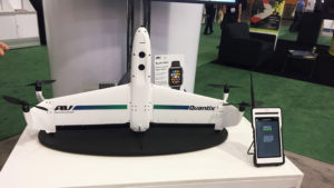
Earlier this month, the military and tactical unmanned aircraft systems manufacturer AeroVironment (NASDAQ:AVAV) proudly unveiled its new QuantixTM drone and a cloud-based analytics platform called the AeroVironment Decision Support System (AV DSS™). The combo is designed with the civil/commercial markets in mind. The drone is a hybrid design that enables the aircraft to launch vertically like a quadcopter and then transition itself for horizontal flight, taking advantage of a fixed-wing drone’s aerodynamic efficiency and range. According to the company, the drone can map 40 acres in about 45 minutes, and its overall flight time is supposed to be an hour per battery.

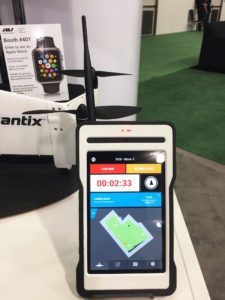
The Quantix is a key piece to a larger end-to-end solution AeroVironment hopes will meet the needs of the agriculture, energy, and transportation industries, among others. Key to AeroVironment’s solution is a proprietary mobile interface that works with their secure cloud-based data storage.


Image courtesy of Skylogic Research


WHAT’S COOL AND WHAT’S NOT


It’s great to finally see AeroVironment come out with an offering dedicated the commercial drones market. While their Puma AE was used for aerial surveys in Alaska—and was the first time the FAA has authorized a commercial UAS operation over land, this product will be the first non-military product in their lineup. So, welcome. Or should I say—I’ll welcome you when you get here. Quantix won’t be available until Spring of 2017. And the price has yet to be announced. However, in my conversations with the company at last month’s Drone World Expo, it’s clear some among their ranks understand it will need to be priced below $20K, or it’s simply not going to sell well.

It’s interesting that AeroVironment chose to target agricultural needswith its first commercial drone. At first glance, the drone looks well equipped for that, with RBG and multispectral cameras. But, boy howdy, are they in for some heartburn when they discover they’ve targeted the most difficult sector to penetrate. We have written againand again about the challenges drone service providers have in providing clear ROI in agriculture (and how bad the forecasts are), but I guess that won’t stop manufactures like AeroVironment from thinking they will somehow buck the trend.

The other problem I see is that their new drone is a tail sitter. Tail-sitter drones are notoriously difficult to land in any wind. I am not alone in this assessment; see another review here. We’ll see if their system is clever enough to compensate for wind gusts, but one thing is clear: there is nothing on the drone to assure a precision landing – no vision positioning system or sense-and-avoid technology in the tail other than a two antenna GPS system. That is so “2013,” and it puts their drone in the same category as a GoPro Karma, which drifts and lands “loud and drunk.


THE COMPETITION:

Most of the companies that serve the precision agriculture market are small businesses. It was clear back in 2014 these companies were working hard to learn firsthand what farmers want from small drones. In doing so, they established networks of distributors and service providers that for the most part have locked other players out of the market.

Manufacturers of small drones for precision agriculture have long since consolidated around DJI and SenseFly because of their (or a third party’s) flight control, mission planning, data services software, and mainly their functional maturity and low cost.

The large aerospace companies and Department of Defense (DoD) contract vendors like AeroVironment do not have a presence in this sector. Even though some have participated in agricultural academic studies, those companies’ products as a whole are unknown in the farming community. They simply have not established the necessary relationships with growers, dealers, coops, agronomists, and local service providers. As a result, it’s probably too late for them to capture any significant U.S. agriculture market share.


BOTTOM LINE:

In my opinion, AeroVironment’s entry into the commercial markets is risky. For one, they are arriving late to the party. Second, the agriculture sector in particular—at least in the U.S.—is already set. I think Aerovironment is going to struggle to move customers from established vendors.

I worry that all this will take some time for them to realize. In the meantime, there is pressure for them to perform. For years, investors have hoped that the company would benefit from the rising interest in unmanned aerial vehicles. Indeed, the recent positive performance of their stock appears to have come in part from the rise in interest in drones due to a more favorable regulatory environment in the U.S. But it remains to be seen whether this new offering will make a difference. We’ll see. In the meantime, join me in welcoming them to the party.


Image courtesy of Skylogic Research


Image credit: Skylogic Research


Read more at:

WALKERA AIBAO VR Drone – Review – FAILS & WINS


The Drone News
November 29, 2016


More at:

Dobby — Smart Pocket Drone In-Depth Review [4K]


The Drone News
November 29, 2016


More at:

Europe, take it easy; you haven’t fallen that far behind!


suasnews.com
By Patrick Egan
November 29, 2016


The grousing from the old world suggests a long overdue circle back on Europe. From what limited contact I have had with companies and industry representatives, I’ve gotten the impression that folks believe they are falling behind. I have to politely disagree as Europe has enjoyed years of experience with thousands of certificated operators while the U.S. has had two. The only thing the Europeans have fallen behind on in my estimation is that the $89 billion (or is it $127 billion) drone industry forecasts is hyperbole.

What I have concluded from visits and conversations with my European friends over the last several years is that they have been working and learning the realities of the drone business. What the drone can and cannot do, data security and that contrary to what they have heard from the headlines, all that glitters may not be drone.

It must be bewildering as you’ve been doing all of these bread and butter jobs i.e. public and private asset management, transportation and other infrastructure projects for years but still have yet to realize the mega billions forecasted for the U.S. market. Maybe it is something in the water, or you just can’t get a good read on tea leaves from the dim light cast by your imported snow blower??

On the upside, I believe that the citizenry has accepted that the drones are not harbingers of a dystopian 1984. Our search engine and social media providers have that locked up tight, and the drone boogeyman is starting to fade here too.


Folks are wound up tighter than an eight-day clock on the Brexit and what that means for drone regulation in the UK as well as those ne’er-do-wells on the mainland. I’d take a deep breath if I were a citizen of the UK. The UK CAA has in my experience always been approachable and pragmatic. The CAP 722 document was something that I employed as an example of what we should be doing in the U.S. on multiple occasions. The only wildcard here is the regulatory personnel shuffle. Folks come and go and without knowing better are in danger of emulating poor regulatory policy from the U.S. Mainland Europe is a little bit more of a mixed bag, but there is more going on there than meets the eye and the geopolitical situation requires thoughtful consideration.

The Global harmonization effort was difficult for us to support from the side of the Atlantic with little or no legal income stream and the regulatory musical chairs. Yes, Part 107 is very liberal and a low barrier to entry. Even with regulation that is more favorable than we could have hoped for just a few short years ago, we find ourselves puzzled by the faltering drone titans. Interesting that almost within the same week as Part 107 went live drone giant 3D Robotics as a drone company went under. Two months in and we have witnessed Trimble sell off their interests in Gatewing and Google cleaning house on Project Wing. The latter could just be a one off as the new axiom on the streets of NorCal is Google is where good technology goes to die.

We hear stories in the press of how drones are changing the world one industry at a time, but quietly on Main Street, the drone rush is proving harder to come by. Some have suggested that I am negative, but in reality, I have always conveyed the notion that drones augment existing business plans well and that their promise has always been primarily self-guided data collection. That is what we experienced in the U.S. when commercial drones were legal, before 2007.

Those in the game had experienced much of what is going on in the post Part 107 situation. The only major difference is that many people did not cease commercial operations and built business and market share in the murky shadows. The best and brightest here in the U.S. have flown, tested and perfected their systems and procedures with little regard for rules as they were “innovating” and no one was going to regulate them or some such drivel. It is all water under the bridge now, but it turns out that it wasn’t only the Luddites down at the FAA that held old Midas at bay. True enough, we didn’t get BVLOS, but there are plenty of blue skies to work with.

If I could offer some advice, I would suggest that this is not the time to get frantic and that you utilize people to work the integration effort that understands the process, applications and realities of the drone business. Here in the U.S. we are suffering from poor decisions and regulations put together by folks who are unqualified and or pushing products to solve the regulator’s problems that may or may not exist. Registration springs to mind as a handy example of a conjecture based debacle. Pay to play representation has not always proven to be Bueno.


Beware Der Schönwetterkönig –

It almost goes without saying that product placement advocacy is hardly ever a good thing for the community. Sadly, those that understand that drones are aviation appear to be the only ones that appreciate the folly. Anyway, I am not suggesting that any one person or one group should have the lock on airspace integration for commercial systems. Any stakeholder (or bagholder) who feels compelled and qualified is, by all means, encouraged to seek an audience with their regulating agency.

I would, however, offer a word of caution on just who one throws their lot in with. This also comes from experience as we are witnessing a plethora of drone advocacy groups which at this point are becoming so numerous and similarly named that for the sake of brevity I will again enlist the help of Monty Python to help dispel the confusion as well as the stringent criteria for association membership –


Upsetting the applecart named desire –

Europe has realized the actual return on what drones can do while operators in the U.S. are still coming to terms with not so gilded reality. You may be inclined to wring your hands in Europe every time you see a headline that talks about the drone industry mega-billions. However, I’d say look at all of the pivoting and partnerings. Would a successful company with boatloads of money and a promising future need to partner with companies without paying customers? Finally, I pose this question for your consideration: in the Airware acquisition of Redbird, which company in the transaction had an income stream?


Read more at:

UAV’s new era is coming —Nokia UAV telecommunication network + MMC hydrogen fuel cell drone


suasnews.com
By Press
November 29, 2016


Drones have entered the world of consumer electronics with such a blast but generally speaking, it still stays in the phase of aeromodelling just like the intercom in the wireless era. Although the UAV technology (such as flight controller, gimbal and obstacle avoidance) has made breakthroughs, there are two major technical bottlenecks hindering the UAV into the era of industrial operations.

First of all, it’s the limitations of wireless communication technology. So far, the effective radius of signal and transmission still hasn’t been able to reach 10 km, which greatly limits the task range of industrial unmanned aerial vehicles.


Secondly, UAV’s flight time can be a barrier. Although the existing lithium battery solution has almost been optimised to extremes, it hardly enables drones to fly for more than two hours. Most unmanned aerial vehicles even have a flight time of fewer than 30 minutes.

Now, new technology is going to solve both problems and it enters the final joint testing phase. As part of its efforts, Nokia’s UAV telecommunication solution enables unrestricted coverage of signals and transmissions, the MMC’s hydrogen fuel cell drone can fly more than three hours and the next generation of drones is expected to fly more than eight hours.


What will happen in the new era of industrial UAV? Hundreds of square kilometres’ range can be monitored continuously for several hours, while you just need to sit in the control centre. And at the same time, route planning can be set, drones can fly in wide range and varieties of tasks can be accomplished automatically.

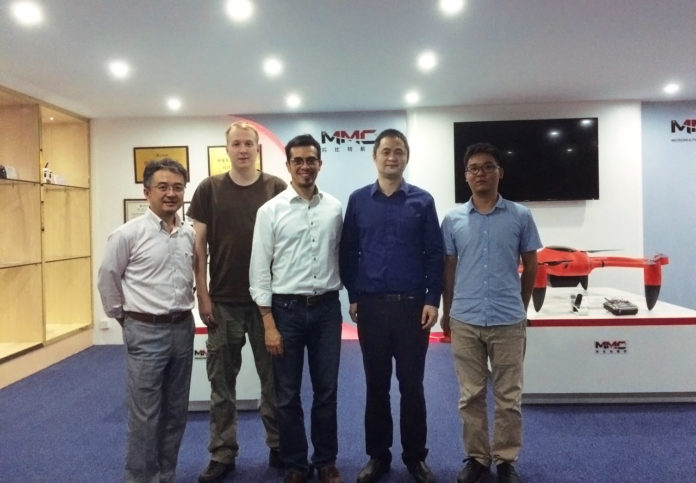
On November 18th, 2016, the expert group of Nokia visited MMC headquarters in Shenzhen, China, and set up a joint test program. This event will be a milestone in the history of unmanned aerial vehicles and it is very promising thatUAV will walk a step forward to the industrial field. The new era of the industrial and commercial drone is coming!

http://en.mmcuav.com/index.html


Read more at:
http://www.suasnews.com/2016/11/uavs-new-era-coming-nokia-uav-telecommunication-network-mmc-hydrogen-fuel-cell-drone/

Monday, November 28, 2016

Boeing ‘Base Station’ Concept Would Autonomously Refuel Military Drones


uasvision.com
Source: Popular Science
November 28, 2016


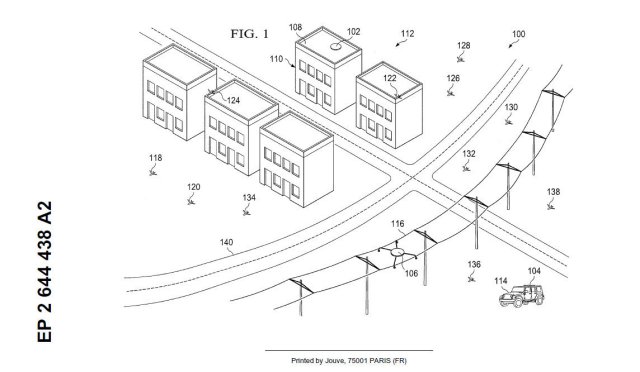
Small drones are already effective weapons for urban warfare—when armed with miniature warheads, these stealthy spies can turn into lethal assassins. So far their biggest limitation is battery life, but Boeing’s patent for a drone battle station sets out to overcome that.

The aerospace giant’s ‘Vehicle Base Station’ resembles Amazon’s proposed recharging stations on street lights, but with a different mission. John Vian, a research fellow at Boeing, says the station’s main applications are likely to be civil and commercial—used for firefighting and search-and-rescue, for example—but the patent has a decidedly military slant. “The unmanned aerial vehicles may monitor for undesired activity… [which] may be the placement of an improvised explosive device in roadway.”

Before coming up with the base station idea, Vian and his colleagues had been looking for the next big thing, and they zeroed-in on ‘fractionated systems’–groups of small ground and air robots working together to carry out tasks. “The patent arose from the recognition that these smaller smarter platforms may have limited endurance,” Vian told Popular Science.


The patent describes a squad or platoon of perhaps 10 to 30 drones, able to follow targets or perch and observe like a fleet of mobile CCTV cameras. When a drone runs low on power it returns to the base station, which physically replaces the drone’s batteries. With no wait for recharging, the drone can fly off again at once. The autonomous battery-swapping device would “enable long, 24/7, uninterrupted missions,” says Vian. In principle, the base station would allow drones to operate in an area for days, weeks, or months at a stretch.


The autonomous battery-swapping device would enable long, 24/7, uninterrupted drone missions.


Clandestine operation is part of the plan. The patent suggests a solar-powered station could be placed on a rooftop where it cannot be seen. Alternatively, the station may be attached to a power line to suck electricity directly from the grid. It could still be covert, hiding in plain sight; few people pay attention to all those black boxes attached to power lines. If some base stations are lost to enemy action, multiple spares would ensure there was always capacity.

Boeing also envisions a line of base stations positioned at intervals of several miles, like gas stations for drones on long journeys. This would allow them to fly right into a combat zone rather than having to be dropped by aircraft.

According to the patent, the base station could act as a shelter in bad weather, a sort of pigeon loft for drones. It may also be a communication hub, housing a satellite microwave link to a remote operations center. In one version of the design, the drones fly missions autonomously, uploading the data they have gathered and receiving fresh instructions each time they return. This would allow them to operate even if all radio signals were being jammed, a growing counter-drone tactic.

The base station might also be able to reload drones with a ‘dispensable payload.’ Fire suppressant is mentioned as an example, though this seems optimistic for small drones–bombs are a more obvious choice. Hezbollah recently released a video of small drones apparently dropping grenades on enemy positions. Similarly, the U.S.’s Switchblade, a lethal drone weighing less than five pounds, carries out kamikaze-style attacks via its on-board munitions. But a reusable attack drone has obvious advantages, especially when the potentially hazardous return-and-reload operation is carried out remotely.

The developers built an indoor test bed to prototype the base station concept using small drones, and they say translating the system into real life deployments would not be difficult.

“With good engineering design, I don’t see major challenges for making this system functional,” says Boeing Commercial Airplanes Senior Research Engineer Emad Saad. “Precise relative navigation is a challenge, but can be addressed with modern sensors and good engineering design.”

Boeing is one of the dominant players in the military market, producing aircraft like the B-52 bomber, F-15 Eagle, and AH-64 Apache attack helicopter. If the base station moves from concept to reality, it would allow swarms of low-cost drones to carry out missions at long range and over long durations, shaking up the market and maybe the entire face of warfare. Perhaps the next big thing from Boeing will be much smaller than the aircraft we usually associate with the name.


Read more at:

http://www.uasvision.com/2016/11/25/boeing-base-station-concept-would-autonomously-refuel-military-drones/

Disney Applies for Drone Airbag Patent


uasvision.com
Source: Orlando Sentinel
November 28, 2016


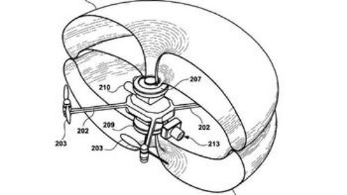
Sketch from Disney patent application shows airbag engulfing Disney drone.
(Disney Enterprises patent application)


Disney is seeking patents for a unique new safety feature for its aerial drone light displays, according to a new patent application filed last Thursday by Disney Enterprises. An airbag has been designed to deploy around the drone, like giant bubble-wrap, if it malfunctions or if sensors detect an imminent collision with another object, the patent says.

Two airbags, on the bottom and top of each drone, would “engulf the entire frame structure and propulsion mechanism… to engulf the hard, sharp and spinning components of the UAV to reduce the effect of impact,” the patent says.

Basically, the airbags would become a bubble surround the entire drone and its propellers. The airbags would also “slow acceleration” in the event of a freefall, the patent says.

Disney has big plans for using drones in light displays at night. It is launching a show called “Starbright Holidays” for the Christmas season using 300 small flying drones to display Christmas trees, doves and holiday colors.

On Wednesday night, Disney showed a 5-minute demonstration of the show, over open water near Disney Springs shopping area. It was believed to be the first time a drone airshow of this scale was performed in the United States.

It’s not clear from the patent whether the drones used in Wednesday night’s demonstration have the airbags described in the patent application. Disney’s media office didn’t immediately respond a request for an interview about the airbags.

The FAA approved the shows, to be performed in areas where people aren’t standing below. In its application to the FAA, Disney said “flight paths will largely take place over water elements and restricted areas” and the drones, called Flixels, would max out at 150 feet above ground.

The drone described in the patent application has storage areas for the airbags. The airbag is “an inflation device coupled to the frame that receives an activation signal and inflates the one or more airbags, based upon receipt of the activation signal to deploy … prior to an impact of the frame with an object.”

The patent application says the airbags would get a signal to deploy if a device called an “accelerometer” detected that the drone was suddenly moving faster than it should be – in a free fall.

The patent application doesn’t specifically mention any possible threat to humans watching the shows. But it does say “As UAVs increasingly fly over locations where people are present, safety for those people is an important goal. Equipment malfunction, aerial hazards, and aerial maneuvers are examples of events which may result in a loss of propulsion.”

The document also says previous attempts at safety features have proven ineffective, such as parachutes that get caught in propellers, or electronic fences that malfunction.

The theme park giant is collaborating with Intel on its drone project.


Read more at:
http://www.uasvision.com/2016/11/28/disney-applies-for-drone-airbag-patent/

Russian Altius-M Long-Range UAV Spotted at Airfield


uasvision.com
Source: SouthFront
November 28, 2016


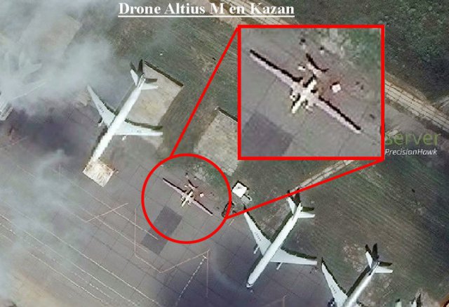
The newest large Russian UAV can be clearly seen on aerospace photos of the Google Maps web mapping service application, the Military Russia informational website reported. According to the website, the photos were taken at the Kazan Aviation Factory (a branch of the Tupolev JSC). Presumably, the UAV is the Russian Altius-M (Altair) newest secret reconnaissance drone, capable to boast of its large duration of the flight.

The photos are dated 25th of September 2014. So, we can conclude that at that time, the Altair were preparing to flight tests or have already passed them.

It is known that the Altius-M (Altair) was jointly developed by the Kazan enterprise and the St. Petersburg company after they won a competition of the Russian Defense Ministry on creation of an UAV in the weight class of about 5 tons in 2011. According to a contract, the developers received about one billion rubles (about $35 million according to the exchange rate of 2011) for creation of the Altius-M.

The newest secret UAV is entirely made of composite materials and has a takeoff weight of up to five tons. The length of the Altair is about 11.6 meters, the wingspan – about 28.5 meters, the span of the V-tail – about 6 meters. The aerial vehicle is equipped with two RED A03 / V12 diesel engines, which have a takeoff power of about 500 horsepower and are equipped with airscrews. The flying range of the Altius-M is about 10,000 kilometers, the flight duration is up to 48 hours.

Supposedly, the Altair is equipped with a station of optical imagery intelligence with an optoelectronic system, based on a gyro-stabilized platform, while a side-looking position-radar station with an active phased antenna array is mounted in the forebody.


Read more at:


FAA Offers Holiday Reminder on Safe Drone Operation


dronelife.com
FRANK SCHROTH
November 27, 2016


short-term FAA Bill


If you’re one of the lucky people who gets a drone as a holiday present, the Federal Aviation Administration wants you to know how to fly it safely. The agency has released a new video reminding everyone of the rules and regulations that safe drone pilots must follow.

As the video shows, before you fly your drone outdoors, the first thing to do is register it at www.faa.gov/uas. If you’re going to operate according to the model aircraft rules, you’ll receive one identification number to apply to all your drones. Non-modelers must register each of their drones individually.

 Read the full release here.


Read more at:


Olympics Authority Establishes the Rules of Drone Sports

dronelife.com
MIRIAM MCNABB
November 28, 2016


The Fédération Aéronautique Internationale, or FAI, claims to be “the world governing body for all air sports recognised by the International Olympic Committee,” and as such, “responsible for world drone sports.” The Federation has issued a statement announcing the formation of a Working Group for drone regulation, “comprised of members of the FAI Executive Board and the Executive of the Aeromodelling Commission as well as senior FAI officials.”

The group intends to develop codified regulations for drone sports, including drone racing.


"The Working Group will deal with sporting and regulatory aspects of drones, ensuring rigorous rules development for Drone Sports, based on the FAI Sporting Code on FPV Racing. This will include the rules for the first FAI World Championships to be held in 2017, and possibly Regional Championships. The group will connect Drone Racing event organisers around the world with FAI, grow the number of events on all levels and organise recognition in the FAI World Cup.


The Working Group will also help member organizations and other drone organizations to collect, assess, and distribute information about drones to regulatory authorities, based on the FAI’s Common Strategy for Drones. The Common Strategy proposes that flight organizations work to establish themselves as resources for the local governing authorities in order to protect their rights and avoid overlapping regulation, and collaborate with drone manufacturers to introduce new players to drone sports. The group will also host a Drone Expo which will combine commercial drone interests with drone sports:


"Another initiative for the group is a planned FAI International Drone Conference and Expo, which will feature FPV Racing as well as panel discussions about Sports development, regulatory and safety aspects as well as the practical uses of drones in areas such as maintenance, agriculture, and aerial filming, where the pilots often get their start in Aeromodelling. Drone manufacturers and student groups will also be invited to participate.


While establishing a set of rules for drone racing could take some time, it could also be the first step toward seeing drone racing featured in the next Olympic games.


Read more at:

DJI Mavic Pro | Tested | Best Camera Settings


thedronenews.com

November 28, 2016


More at:

http://thedronenews.com/2016/11/28/dji-mavic-pro-tested-best-camera-settings/

Sky-Futures USA Inc. is the world’s first approved drone specialist for vessel inspections


suasnews.com
By Press
November 26, 2016


Sky-Futures USA Inc. has been certified as the world’s first approved drone specialist for internal vessel inspections by American Bureau of Shipping (ABS). ABS surveyors have now certified drone data as an additional, valuable inspection tool to make critical decisions affecting classification and statutory surveys.

Sky-Futures was awarded the ‘External Specialist Rating’ by ABS following a series of in-depth assessments, including an in-office audit of all safety and inspection procedures and a two-day survey demonstration on a bulk carrier. Inspections were conducted in the cargo hold and in the intricate geometry of the Fore Peak Tank and Lower Stool Space of a Bulk Carrier.

Jay Forte, VP Operations Sky-Futures USA, said: “We’re very proud to have been awarded this rating by ABS and to have become the first approved drone specialist for vessel inspection. We have particularly appreciated the recognition of our outstanding operational safety and procedures by ABS, an organization which is globally acknowledged for setting standards for safety and excellence in classification in the Marine and Offshore industries.”

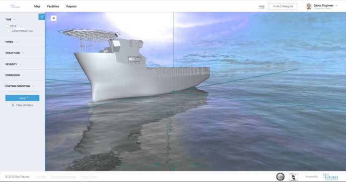
This successful demonstration and certification by ABS reinforces the effectiveness of Sky-Futures drone-based Confined Space Inspection service. Sky-Futures now offers the Marine and Offshore industries an accredited service and the capacity to fully exploit the use of drones and drone-based data analysis to improve safety and reduce risk on client facilities. Sky-Futures supplies all reports through their proprietary software, Expanse, which revolutionizes the way drone-based data for industrial inspections is analyzed, viewed and managed.


Read more at: