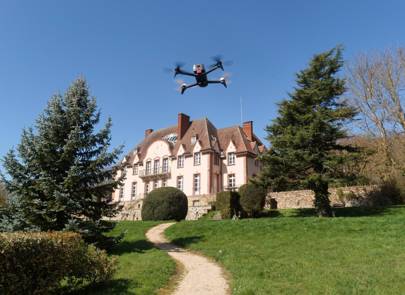
Parrot's Bebop 2 Real Estate Advanced Edition drone and Pix4D software will create a model in less than an hour
wired.co.uk
By MATT BURGESS
13 December 2016

Parrot / Pix4D
Drones may be seen as the reserve of the hobbyist, but they have so much more potential. They can be used for mountain rescue missions, deliver packages, and provide internet connectivity. Their most popular use to date though is capturing video and images.
Now, tech company Parrot has teamed-up with software creators Pix4D to make a UAV that can scan and create a model of your home (or anyone else's home for that matter). The drone – Bebop 2 Real Estate Advanced Edition– hovers above and flies around a property capturing images of it before they are translated to a digital format.
"The Real Estate edition of the Bebop 2 enables you to quickly and easily create the 3D model of a property of your choice then to use it directly on your website or as part of a 3D-printing project," Parrot, which has just released the $899.99 (£708) drone, says on its website.

Parrot / Pix4D
The drone weighs just 500g, can fly for 25 minutes and captures 14MP photos or full HD videos – image stabilisation technology is also included. For those buying the Real Estate package, the price also includes a one-year licence for Pix4D's software package. Pix4D says the creation of it virtual models is completed in the cloud and can be customised if needed.
To show the potential of the two technologies, Pix4D has scanned and 3D-modelled a French chateau.
"To map the 500m2 property, a Parrot Bebop 2 drone flew one grid flight to capture the chateau gardens and horizontal surfaces, and one circular flight around the main building to capture facade details," Pix4D explains. Following the flight 109 images taken were transferred to the firm's cloud and used to create a digital model.
It says the "photorealistic 3D model" was completed in 30 minutes and then a 3D-printed model of the chateau was produced.
Read more at:
No comments:
Post a Comment