Showing posts with label agriculture. Show all posts

Thursday, February 2, 2017

Agricultural Drones Can Save You Millions


droneblog.com
By Droneblog Editor
February 1, 2017


According to a study conducted by Informa Economics and Measure, corn, soybean and wheat farmers could save an estimated $1.3 billion dollars annually by utilizing drones. The report claimed that the biggest beneficiaries would be corn farmers as they could save a huge $11.58 per acre and could see an increase of crop yields by about 3.3 percent. These incredible statistics might sound too good to be true, but we are here to let you know that agricultural drones really do have amazing features that can save you lots of money.

Drones have really come a long way since when they were first designed. Originally built for surveillance and military operations, these unmanned aircraft have found many different uses over the years. An incredible way of accumulating intelligence in an area too dangerous for men and women, they can fly into enemy territory and provide incredible video footage of possible threats. They have then been modded and redesigned for more recreational use. Drones have now found their way into people’s homes, they make brilliant gifts for anyone looking for a fun and exciting flying experience. As soon as they became widely available to the public, people began to see the potential in drone racing. This has now become an incredibly exciting sport, going from strength to strength and gaining more and more attention from all over the world. Feel free to read more about drone racing here. However, one of their more surprising uses is in the agricultural world. Robust, intelligent and packed full of hi-tech features, agricultural drones have the ability to make a farmer’s life easier and we are here to explain why.


WHY DRONES HAVE MADE SUCH AN IMPACT IN AGRICULTURE

There are many reasons as to why drones have had such a positive impact in the agricultural industry. Farming is truly back-breaking work, early hours and long days make for a hard day’s work, so the invention of something that can help lighten the load will always be welcome within the farmer community. Agricultural drones not only help with the workload but can actually help boost a farm’s performance. Although it sounds too good to be true, it really isn’t and we are here to show you why this is indeed true.


CROP SURVEILLANCE

Ensuring the health of a crop is, of course, an absolute priority for any farmer. A more unorthodox way of monitoring a crop is by using a drone’s camera abilities. A drone measures a crops health by looking at changes in visible light and near-infrared light reflected by the crops. Depending on how healthy they are, plants reflect different amounts of visible green and near-infrared light.

Viewing this from the air provides the user with the chance to expose any possible problems which can’t be seen from the ground, such as pest and fungal infestations. Another fantastic feature on an agricultural drone is the infrared camera feature. This, combined with the normal images can perfectly highlight any differences between healthy and unhealthy plants, which can’t always be seen by the naked eye. There is also a converter in the camera, if it has been upgraded, which can measure the NDVI (Normalized Difference Vegetation Index) of a crop, giving an incredibly precise and detailed image of the density and health of the vegetation. Not only this, but some drones also have an ultraviolet image setting meaning the farmer can see another level of distress in the plants.


THERMAL SECURITY

A truly sad fact is that, in South Africa, there are so many farm murders each year that farm security needs to be a top priority. Not only to protect your crops and produce but also to protect yourself and family from any possible harm. A huge benefit of agricultural drones is that they are equipped with thermal imagery. Using temperature, thermal drones can detect humans or animals in a crop that could be hidden from sight. Having a drone that not only helps to look after your farm but also protects it is something that all farmers could really benefit from.


THE VIEW

It may seem obvious, but a drone can provide views of the farm that the owner may have never seen before. Not only do they display an incredible aerial view, but also record in HD, meaning the farmer can watch the high-quality footage as much as they want and find out where needs work.


DRONE MAPPING & CROP DUSTING

Agricultural drones have the ability to dust crops on a completely unique and bespoke path. Working through an autopilot feature, once the drone’s flight path has been mapped out it can be left to its task, which it will then do efficiently and effectively. Prescription maps are also there to inform the farm owner what the farm needs, such as increasing or decreasing nitrogen spread on unhealthy spots. Drone mapping has the potential to improve a farm’s productivity and ensure that only quality and healthy crops are grown. It has also never been easier thanks to the Drone Deploy app, available for Iphone and Android users. Free and easy to use, the app perfectly captures data any farmer needs and includes 3D modelling and high-quality interactive maps. Compatible with the latest DJI drones, it allows the user to fly autonomously with just two taps of their phone.

So, if you are thinking of getting a drone to help with your farm then a drone which perfectly combines all of these features is the DJI AGRAS MG-1. Purpose-built to deliver maximum efficiency, reliability and longevity, it can cover 7-10 acres an hour and can carry up to 10kg of liquid payloads. Its speed and power allows it to effectively cover an area of 4,000-6,000 m² in just 10 minutes which is up to 60 times faster than manual spraying options. Not to mention the Phantom 4 and the Phantom 4Pro + with DroneDeploy which is perfect for mapping. Powerful, reliable and advanced, the Phantom 4Pro boasts a sharp 4K camera and a 5-direction obstacle sensor, which makes it intelligent enough to navigate its way through any kind of farm. DJI are famous for making some of the best and most impressive drones around, and that is no different with any of these.

Agricultural drones are there to not only help lighten the workload on a farm but also increase the amount of produce. If you have any questions on how these can help you, please feel free to get in touch with us by either email or phone:

Phone: 0215512648
Cell: 0834638310
Email: info@smashtronics.co.za


Read more:

Wednesday, February 1, 2017

The 7 Best Agricultural Drones on the Market

dronelife.comBY MIRIAM MCNABB
JANUARY 31, 2017


By Nicholas A. Tonelli (Flickr: Nittany Valley Farms) [CC BY 2.0 ]DRONELIFE originally published this article in 2014 – this article has been completely updated from the original as of 2017.


While drones are spreading into industries from warehousing to oil exploration, precision agriculture remains one of the most robust segments of the market. The ROI for drones in agriculture is compelling: and farms of every size are taking advantage of drone technology.

Three years is almost a lifetime in the drone industry, and much has changed since DRONELIFE first published our first list of the 7 Best Agricultural Drones on the Market. With new technology, new regulations, and new software and service offerings farmers have more tools to work with than ever before.

Some of the drones on our list remain from the original: PrecisionHawk (Lancaster) and SenseFly (eBee) have been major players in the drone industry and are continually improving their offering. The AgEagle is a drone specifically designed in collaboration with researchers at Kansas State University for precision agriculture, and it does the job well; HoneyComb’s AgDrone is another drone designed with agriculture in mind. But the rise of the prosumer drone, and the move by traditionally recreational drone companies like DJI into the professional space, have created more options. New services that provide qualified drone pilots have created a realistic choice for agronomists who don’t also wish to become Part 107 certified.

Let’s start with some of the leading commercial manufacturers in the industry: North Carolina-based PrecisionHawk and Parrot’s Switzerland-based senseFly.


image courtesy PrecisionHawk

PrecisionHawk takes a forward position not only in the production of commercial drones, but in all aspects of UAV technology. They are instrumental in the work of drone integration in the US, and are a prominent voice in drone regulations efforts. And while the company sells commercial packages that include DJI prosumer drones, their own Lancaster model remains an industry leader. The Lancaster can be used across industries: including mining, energy, and inspection; but its ease of use and durability make it ideal for agriculture, especially in difficult conditions. Lia Reich, PrecisionHawk’s VP of Marketing and Communications, says the platform is perfect for precision ag – and has stood the test of time. “PrecisionHawk’s first platform, the Lancaster, has been consistently updated as we learn and better understand the needs of our customers. Currently on its fifth iteration, the Lancaster fits the agriculture market’s need of capturing consistent data across large areas, but we have also seen significant growth for research applications,” says Reich. “The platform is well suited for enterprise seed and chemical companies and university researchers who need to fly various types sensors for advanced remote sensing applications. Engineers at PrecisionHawk have been able to differentiate the Lancaster from the other platforms the company sells, including the DJI M100 and M600 Pro, by integrating sensors like thermal and LiDAR while also improving durability and overall flight performance. In the end, the goal is to ensure accurate data collection on every flight. To do so, we continue to make the platform more autonomous and user-friendly to ensure the seamless integration of drone technology into our client’s existing workflows.”


image courtesy senseFly

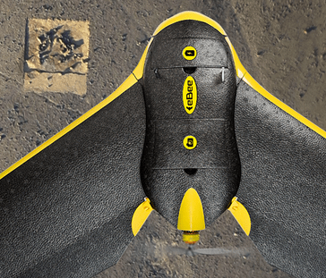
senseFly’s eBee drone is another industry name found on our original list. Referred to then as the “eBee Ag Drone” it’s now the eBee SQ, a lightweight fixed-wing with Parrot’s fully integrated Sequoia camera. eMotion Ag flight planning software is designed to help integrate the drone into existing workflows. And the flight range – which senseFly says results in fewer flights – makes it an effective tool for large scale farms. The company has been diligent in keeping the platform evolving. “The eBee SQ allows agricultural professionals to collect highly precise data on the health of their crops, efficiently and cost-effectively,” says Jean-Christophe Zufferey, senseFly’s CEO. “It represents a platform-proven upgrade for those who may have been trialing drone technology—for example by flying quadcopters over their crops—including those who already own a Parrot Sequoia. By upgrading to the eBee SQ, these operators gain a professional-grade, easy-to-use system that can cover many more acres in a single flight.”

Two more of the drones on our list were also on the original. Designed specifically for agriculture and sold almost exclusively for that purpose, Oregon-based HoneyComb provides an all-in-one hardware/software/data storage solution with their AgDrone. The composite drone was built for durability and flight endurance. Two cameras provide an array of data; and HoneyComb provides their own data processing services to provide actionable information. Additionally, the company claims that the AgDrone System™ features an advanced autopilot system that allows “the drone to fly itself. No flying experience required.” (Note – in the U.S., while the drone may not require experience, the pilot needs a Part 107 license to fly legally for agriculture.)

The AgEagle was designed for agriculture in collaboration with researchers from Kansas State University. The AgEagle RX 60 claims to be “the most durable, lightweight, professional-grade drone technology on the market.” The carbon-fiber, electric powered drone has a flight endurance of 45 -60 minutes. The RX 60 is outfitted with a modified GoPro camera for data collection, and AgEagle offers a proprietary cloud processing system. The company says that in-flight data processing is in development. “The nature of farm equipment is that it takes a serious beating over time,” said our original article. “In anticipation of this issue, the AgEagle is outfitted with a composite shell of fiberglass and carbon fiber cloth in addition to a poly carbonate skid plate… It’s an aerial tank that can fly in winds up to 20 miles an hour.”


DJI’s Phantom 3

New to the list are offerings from drone manufacturing giant DJI. DJI has two different offerings that have a significant presence in precision agriculture: the prosumer Phantom or Matrice lines, fitted with tools for precision agriculture; and the AGRAS MG-1, DJI’s first professional agriculture drone. Because so much of precision agriculture is in the software platform that turns data into actionable information, companies like PrecisionHawk have created cost-effective packages that combine a ready-to-fly DJI drone with software and data processing services. Additionally, independent drone operators who provide flight services – and a drone – to farmers are more likely to use one of these prosumer drones, which can serve multiple purposes. But DJI is also moving into the higher price range of agricultural drones, with the AGRAS MG-1, introduced at the end of 2015. The foldable-arm octocopter is not designed for data gathering, but for action plans: carrying a payload and sprayer system for precision application of fertilizer, pesticides, and herbicides.

Finally, the last on our list isn’t a drone; but an updated reference article would not be complete without a mention of the outsourcing services now available. As the industry has evolved and regulations have become clearer, many farmers may decide to outsource drone programs rather than bringing them in-house. (It should be noted that in the US, all use of drones for precision agriculture is considered “commercial” – even if it’s your own farm that you are flying for. Any agriculture application in the US requires a Part 107 Remote Pilot’s license.) Services like Measure offer a turnkey agricultural solution, providing the drone, pilot, and data. Smaller commercial marketplaces like JobForDrones list licensed commercial operators and specialties in every region; and data platform providers like DroneDeploy provide lists of licensed operators who can use their data platform to provide actionable information to farmers.

With the industry expanding, drones are poised to make a difference in many verticals. But while agriculture was one of the first to take advantage of drone technology, it remains among the largest applications that get the benefits of a birds-eye view.


Read more:

Tuesday, January 31, 2017

Seven Ways to Use Drone Mapping on the Farm This Season

dronelife.comBY FRANK SCHROTH
JANUARY 31, 2017


Guest post by DroneDeploy —

As one ag industry expert put it, using a drone on the farm is like being able to see your field from a 10,000-foot altitude, but also being able to zoom in to two inches above the plants. Growers are increasingly discovering that drone mapping is an invaluable tool, both for its ease of use, and for its many applications on the farm.


“It’s like being able to see your farm from a 10,000-foot altitude, but also being able to zoom in to two inches above the plants. There’s no other system that can do that.” — Rob Eggert, TDS fertilizer.

With the growing season fast approaching, we’ve put together a list of some of the most popular ways growers are using drones to improve their processes and make informed decisions about their crops.


1. Crop Scout to Detect Parasites and Fungi


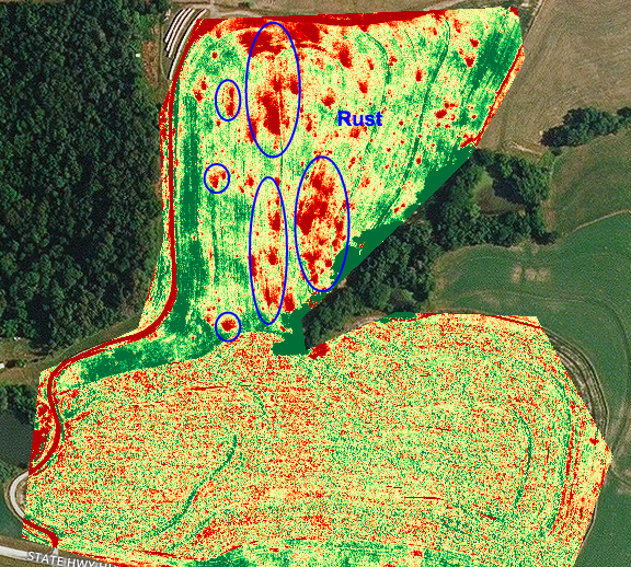
Growers like Brent Gerke are using drone mapping to pinpoint plant health issues such as parasites and fungi. The very first time he used drone mapping software, Brent realized that by switching to the plant health map in his DroneDeploy dashboard, he could see areas of rust fungus in his wheat crop. Clear sections of red coloration on the map enabled him to quickly and easily identify the extent of the rust in the field.


Grower Brent Gerke’s plant health map helped him identify the extent of rust fungus in his wheat crop

Similarly, Tyler Smith in the Imperial Basin of California uses drone mapping to check alfalfa fields for dodder, a spaghetti-shaped parasitic plant that renders alfalfa seed virtually worthless. The only way to kill dodder is to burn it, so if a grower can catch it early, when the affected area is about the size of a table, they can contain the damage. Spotting such a small patch of dodder is difficult, but DroneDeploy’s plant health map allows growers to do just that.


“If you found a spot [of dodder] as big as the table, you could fix it right away as opposed to having it spread — big savings in terms of the amount of labor it would take to contain it.” — Tyler Smith


2. Compile Plant Counts

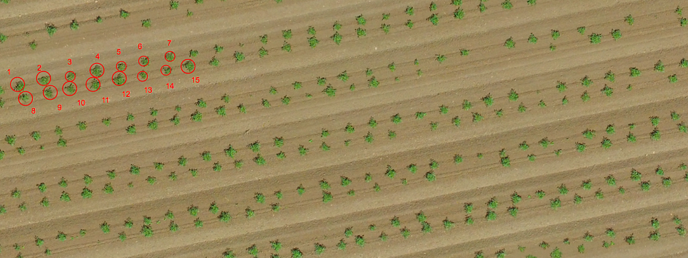
One of the most exciting uses for drone mapping in agriculture is the ability to conduct complete, accurate plant counts. Instead of relying on time-consuming manual counts taken on just a small portion of a field, growers like Toshiro Aoki are using drones to compile automated plant counts of entire fields in a matter of hours.

“The plant counting seals the deal. It saves us the trouble of having to go out and count the whole field.” -agriculture consultant Toshiro Aoki

Toshiro works for a private farm in Northern California. During last year’s growing season, hundreds of thousands of tomatoes plants were transplanted on a 74-acre field by an outside company. Toshiro wanted to make sure the company was billing them only for the established plants, so he used AgriSens, a third-party tool available right within the DroneDeploy dashboard, to quickly and easily get a plant count report that helped him hold the company accountable.


3. Analyze Stand Establishment


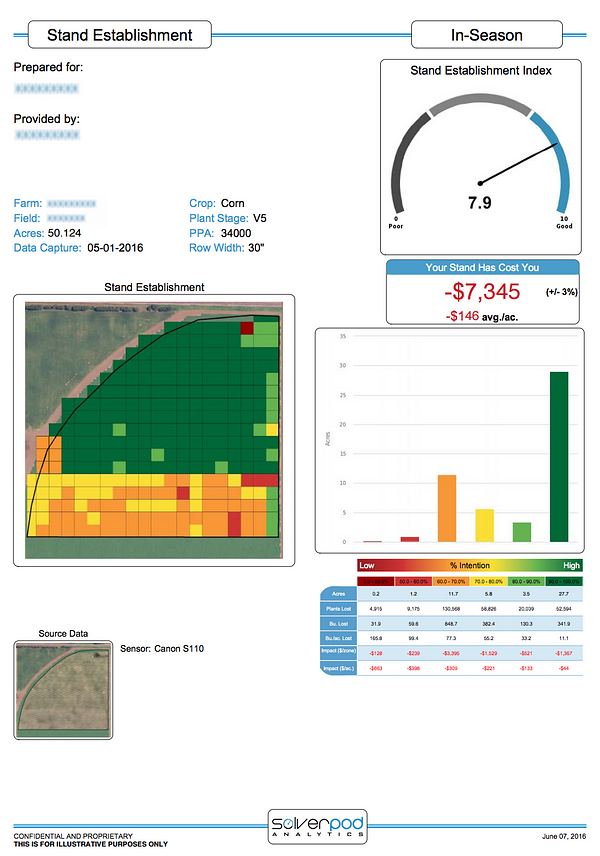
Aglytix provides corn and soybean growers with a detailed stand establishment report from within their DroneDeploy dashboards

In addition to plant counts, corn and soybean growers are using drone mapping to analyze stand establishment of newly planted crops to decide whether they need to replant certain areas. From the DroneDeploy dashboard, growers can send maps of their emergent fields to ag-focused analytics company Aglytix. The company uses the data to create a report that details crop emergence throughout an entire field, providing a far more comprehensive picture than on-the-ground sampling. The report also includes a stand establishment index and a calculation of the economic loss on the field.


4. Generate Variable Rate Prescriptions for Nitrogen and Pesticides

Ag expert Landon Oldham realizes that drone maps provide him with a rich amount of data that can be used to make more informed decisions about issues like crop reseeding and targeted nutrient applications. Growers can export their drone-generated, zoned shapefiles into Ag industry software to easily generate variable rate prescriptions for nitrogen, pesticides and other applications. He is taking this even one step further.

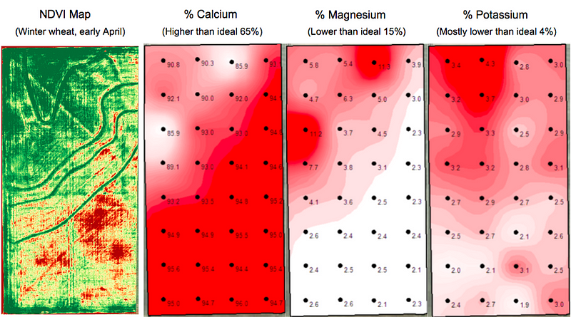
Drone map shows strong correlation to soil sample results, but with more detailed data
Landon owns Heartland Soil Services, a company that uses soil samples to estimate crop yields and make variable rate prescription maps. He is developing a workflow that combines drone imagery with soil samples to make even more accurate nutrient prescription maps. Instead of relying solely on data from soil samples — about one sample per two acres — Landon’s new workflow combines this sampling with the many data points on a drone-generated NDVI map to gather information at a much more granular level.


“The ROI could be tremendous because growers could further increase the site-specific application of any and all products rather than flat rate applying the entire field at the exact same rate.” — Landon Oldham, Heartland Soil Services


5. Assess and Clean-up Damage After a Storm


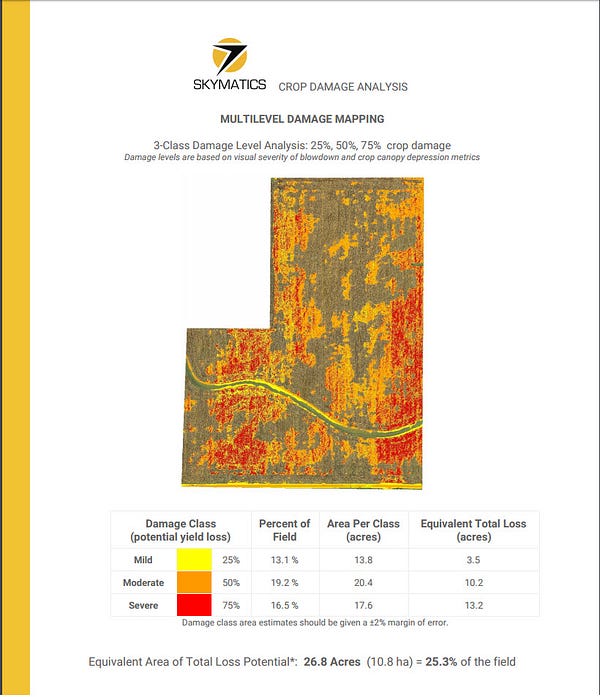
Jeremy generated a Skymatics crop damage report directly from his DroneDeploy dashboard

When heavy winds and exceptional rainfall downed corn on a 105-acre field in central Illinois, Jeremy Jones of Overhead Ag used DroneDeploy, paired with a detailed Skymatics report, to help the farmer and seed rep assess the extent of the damage. Instead of relying on traditional ground scouting, which could easily have missed catching large portions of downed crop, Jeremy used his drone to capture a complete picture of the field. Then, with just the click of a few buttons, he generated a detailed Skymatics crop damage report directly from his DroneDeploy dashboard.

The report included a calculation of crop loss and a categorized damage map that gave the farmer and seed rep a far greater understanding of the storm’s damage.


“It’s a nice, polished document that provides way more information on loss than I was getting by measuring certain areas.”- Jeremy Jones of Overhead Ag, on the Skymatics report he generated with his DroneDeploy map


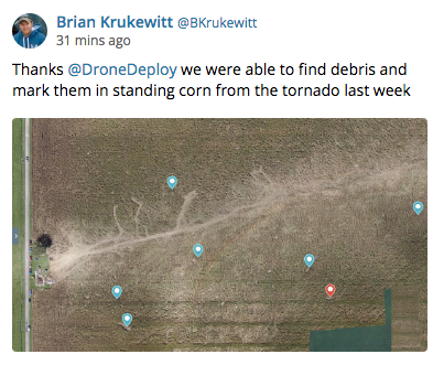
Drone maps can not only help estimate the extent of damage, but in some cases can even help when clean-up is needed. When a tornado tore through his corn and soy fields, tossing debris throughout his crops, Brian Krukewitt made a drone map to spot debris hidden by standing corn and plan to efficiently remove it, whether before or during harvest.


6. Negotiate Fair Crop Loss Percentages


As every grower knows, crop loss is always a possibility — and that’s why many choose to insure their crops. But because insurance adjustors only have time to walk small sections of a damaged field, gaining an accurate picture of the loss can be difficult. This past summer, Gregg Heath of Silicon Falcon Micro Aviation used drone mapping to help a tobacco grower recover a fair loss percentage after heavy rains decimated nearly 100 acres of his crop.


“Drone Deploy is really tailor made for when you are surveying crops,” — Gregg Health of Silicon Falcon Micro Aviation. [click-to-tweet]

Gregg’s annotated crop health map, produced in just a few short hours, convinced an insurance inspector to re-inspect the field after an initial loss estimate fell short of expectations. Thanks to the detailed information provided by Gregg’s drone map, the adjustor took a second look at targeted areas and ultimately offered a far higher loss percentage. The grower ultimately recouped an additional $110,0000 in crop losses.


7. Assess Slope and Drainage After the Harvest

Although this year’s growing season is just beginning, it’s never too early to look ahead. Curt Moore at Agflyers reminds farmers that there are many uses for drone maps even after the harvest. “Once harvest is complete and post-season field prep is complete, you’re essentially left with a blank canvas,” says Curt. “Why not produce a map of your land in this state?”

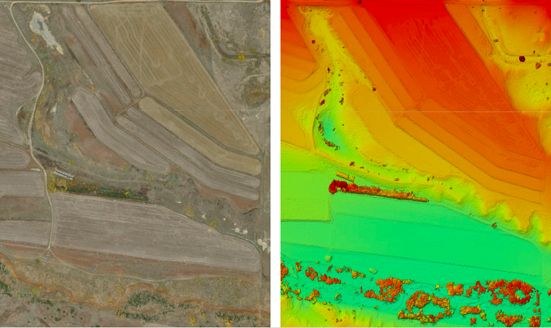
With crop cover out of the way, Curt suggests using a drone-generated elevation map to get a sense of the slope and drainage of a field. Paired with DroneDeploy’s easy-to-use volume measurement tools, growers can plan the cut and fill of future terraces and waterways.


Orthomosaic map (left) and elevation map (right) of a terraced field. Areas in red are higher, areas in blue are lower.

Some growers, like Sam Meeker, take this one step farther, by comparing maps of their drainage systems — in Sam’s case, a map of bare dirt where tile lines are clearly visible — to their yield maps to evaluate the effectiveness of new tiling and decide whether to invest in additional drainage tiles.

Regardless of the crop or region, growers who integrate drones into their work quickly realize that they are easy to use and offer many possibilities. This coming season, growers will continue to use drone mapping to make life on the farm more streamlined, efficient and informed.


Where to Learn More

Thinking about bringing drone mapping to your farm? Be sure to read Seven Common Questions about Drones in Agriculture. For even more tips on using drone mapping in agriculture, check out our webinar, Lessons from the Field, with ag experts Chad Colby and Jim Love.

And as always, take a look at our ag-specific support documentation, such as:
Using Third-Party Plant Count Tools in Your DroneDeploy Dashboard
Onboarding for Agriculture
Understanding NDVI


Read more:
http://dronelife.com/2017/01/31/seven-ways-use-drone-mapping-farm-season/

Sunday, January 22, 2017

Free online seminar explains the cost and process of drones in agriculture


dronelife.com
BY MIRIAM MCNABB
JANUARY 19, 2017


With the clear benefits that agronomists get from a birds’ eye view of their crops, precision agriculture has been one of the leading applications of drones across the globe. The technology offers incredible advantages: with the data provided by drones farms of any scale can conserve resources, monitor crops, make better predictions, and save money.

But in precision agriculture as with many commercial drone applications, companies can be hesitant to invest in new technology without a clear understanding of the cost benefit. Now, with their line of commercial drones having flown more than 300,000 flights and 90,000 hours over more than 30 million acres, senseFly will host a webinar to lay it out clearly. senseFly, the Parrot company behind the lightweight professional eBee drone, will host the free webinar at 10:00 EST/16:00 CET on Tuesday, January 24. “The information shared during this webinar will help those in agriculture understand the value drones can bring to their business,” Nathan Stein, senseFly Ag Solutions Manager, tells DRONELIFE.

During this event, experienced operators from two of the ag market’s agronomy leaders—AIRINOV (France) and Deveron UAS (Canada)—will discuss their companies’ drone use, including the opportunities and challenges that adopting this technology brings. Attendees must register in advance for the one-hour webinar, entitled Ag Drone Insights – Experienced Agronomists Discuss UAV Results, Costs, Workflows and More.

“Across the globe, agronomists, growers and researchers are increasingly using drones to gain deeper insights and to optimise their operations,” said senseFly’s CEO, Jean-Christophe Zufferey. “This webinar will help professionals who have yet to adopt UAV technology to more fully understand how and when drones can help drive their businesses, and those of their clients, forward.”

Topics covered in the webinar will include:
· How to choose, adopt and operate ag drone technology
· The different drone applications possible — from scouting to irrigation planning
· How to manage drone data and transform this into marketable products
· The real cost of ag drone ownership
· The impact of drone regulations on doing business
· How to build a scalable business based on drone generated imagery

Entrepreneur and farmer Norm Lamothe, head of UAS agriculture at Deveron UAS, will demonstrate how Deveron UAS employs drone tech across eastern Canada to more accurately analyse the health of its clients’ crops, optimise their applications, predict yields and identify issues such as disease and infestation.

Agricultural engineer Erick Lebrun, communications manager at AIRINOV, will discuss how AIRINOV combines its expert crop insights with data from senseFly fixed-wing UAVs to help its customers produce more and optimise their time. For example, he will detail AIRINOV’s work with OCEALIA Groupe, a large French farming cooperative, whose farmers have benefitted from a 10 percent yield increase since employing AIRINOV’s drone-based consulting services.

In addition, senseFly will provide a glimpse into the company’s newest advanced agricultural drone, the eBee SQ.


Read more at: