Showing posts with label drones. Show all posts

Saturday, February 18, 2017

Renewables – Profiting in the era of drones PrecisionXYZ

suasnews.com
By Mark Culpepper
18 February 2017
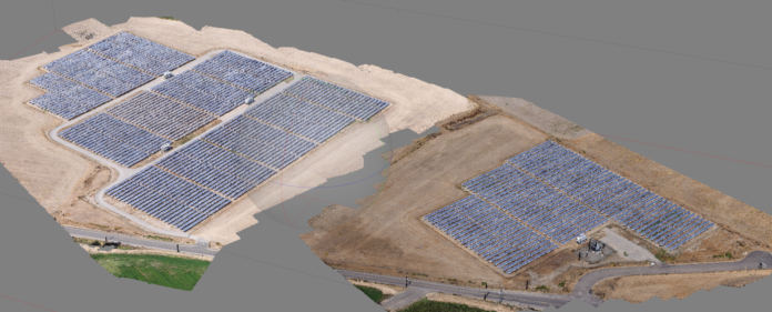


In the modern age of solar 4.5 MW is not a big power plant, generally occupying less than 50 acres of land. But from the perspective of a field technician, size is all relative.

A Needle in a Haystack

“A plant that size has about 18,000 panels,” says Rick Lavezzo, the owner of ArrayCon, one of the nation’s largest builders of utility-scale solar power plants. “And trust me, if you’re trying to find a bad panel out there it can be like looking for a needle in a haystack.”

Rick should know; his firm was recently hired by a plant owner to find and replace a run of bad solar panels on a 4.5-MW power plant. “If we had to do this the traditional way, it literally would have taken us weeks. I’m not even sure the plant owner would have decided to do it if that’s the path we’d taken.”


Fortunately, they were able to take a different path — they used a drone service provider (or DSP in the lingo of the age of the drone) to spot the bad panels for them before they serviced the plant. Using a thermal sensor and a sophisticated flying robot that looks vaguely like something from a Batman movie, PrecisionXYZ was able to fly the entire site in under 40 minutes and provide ArrayCon with the results the next day. Not only did they spot the bad panels, they identified a number of strings that were offline and an entire subarray that was tracking incorrectly.

Thermal imagery combined with drones are a real game changer for maintaining these assets. Because energised assets like solar panels generate heat, a drone equipped with a thermal camera allows you to quickly assess the site and easily spot the problem areas. It’s almost like that ‘needle in haystack’ has a blinking light attached to it. It really accelerates the entire troubleshooting process.

Accelerating Build Times

But drones can have an impact on solar economics long before the power plants are even built; by accelerating build times they are driving costs out of the entire structure for the solar industry. Tom Werner, SunPower’s CEO recently told investors that drones could reduce their power plant construction costs by up to 30 percent. When you consider that a 100-MW power plant can cost up to $200 million, that’s a big a deal. The question asked by many is simple; how?

Consider that 100-MW power plant — $200M doesn’t just fall out of a tree. A bank or other investment vehicle sets that money aside in order to create that cash-producing asset called a solar power plant. And the moment the bank sets that money aside the clock starts ticking. Every day in which that money isn’t earning returns for an investor translates into opportunity costs.

“That whole saying about ‘time is money’ — that’s the construction industry in a nutshell,” Lavezzo said. “It’s about how quickly you can build a quality project so the bank can start making money off that asset. So project velocity isn’t just important, it’s everything.”

For solar power plants, that clock starts ticking with something called a site assessment. Think of this as pre-screening of a site’s viability for project development. Historically these were done with Google Earth or an equivalent online or subscription service. The challenge with these tools is that the imagery and accuracy can be very course, requiring project developers to spend more time assessing the site.

With high-resolution drone imagery, every detail of the site is visible within days. SunPower estimates that by using drones, they can cut 90 percent off the time it normally takes to build a proposal ready site assessment. Of course, once a site is deemed favourable for a project, you still need to actually build it. And here too, drones play a big role in accelerating the entire process.

Traditionally, land surveys for projects are conducted once a project is approved. Even with modern survey-grade GPS technology, the process is labor-intensive, and it can easily be more than a month before a survey is completed. That’s critical time when capital is sitting on the table. In contrast, drones flying over a site use a process called photogrammetry to build highly accurate maps very quickly.

Photogrammetry itself is not new and was used extensively during World War II for aerial bombing mission planning and post bombardment assessments. In general, the higher and faster you fly, the lower your detail and accuracy. Conversely, flying “low and slow” gives you greater accuracy and detail. This is why drones are the ideal solution for building extremely accurate topology maps across large areas.

At PrecisionXYZ, we’re very comfortable building topology maps across a thousand acres. Drones are an ideal use case for large, utility-scale solar power plants.

Not only does this accelerate the front end of the project, but it also provides design and engineering teams centimeter-level fidelity. This allows them to more accurately estimate resource utilisation at the project site, further reducing project costs. And since the information is provided in the form of a digital model, construction organisations can now integrate that information into their project tracking, which leads us to yet another area where drones help drive out costs.

A New Perspective on Project Management

Tracking project velocity across a 100-MW to a 200-MW site is not easy; you are tracking work crews across literally hundreds of acres, and each crew has their own set of challenges. For the overall project manager, this can create a situation where information is disjointed, and without the context of the overall job site, it can be difficult to assimilate for quick decision making. This can end up hindering their ability to manage the site effectively.

Drones re-establish site context, delivering images of the entire project site in real time, allowing a manager to see at a glance the status of the overall project. More importantly, it enables them to address a host of issues that might not otherwise be obvious — be that manpower, material or safety, all of which can impact project velocity and ultimately delivery. Because all the information is now digitised and stored in the cloud online, this also allows project management teams to more easily analyse the results of not only the current project but of projects conducted in the past. Lessons learned can then be applied for better results in future projects.

The net result is an immediate improvement in project velocity and continuous improvement in project velocity over time. In an industry that is constantly trying to find another $.01/watt of savings, the potential savings drones represent huge.

At the end of the day, drones are a robotic tool designed to extend the capabilities of people, teams, and managers. And while the first era of drone technology was simply about making drones reliable, consistent and functional, the second era — the era of data collection — is having a much more profound impact. In the age of automation, drones are the front-line forces driving value creation in construction economics.


Read more:

Friday, February 10, 2017

Drones Bring Power to Remote Areas: the MMC Spider Solution

suasnews.com
By Press
10 February 2017


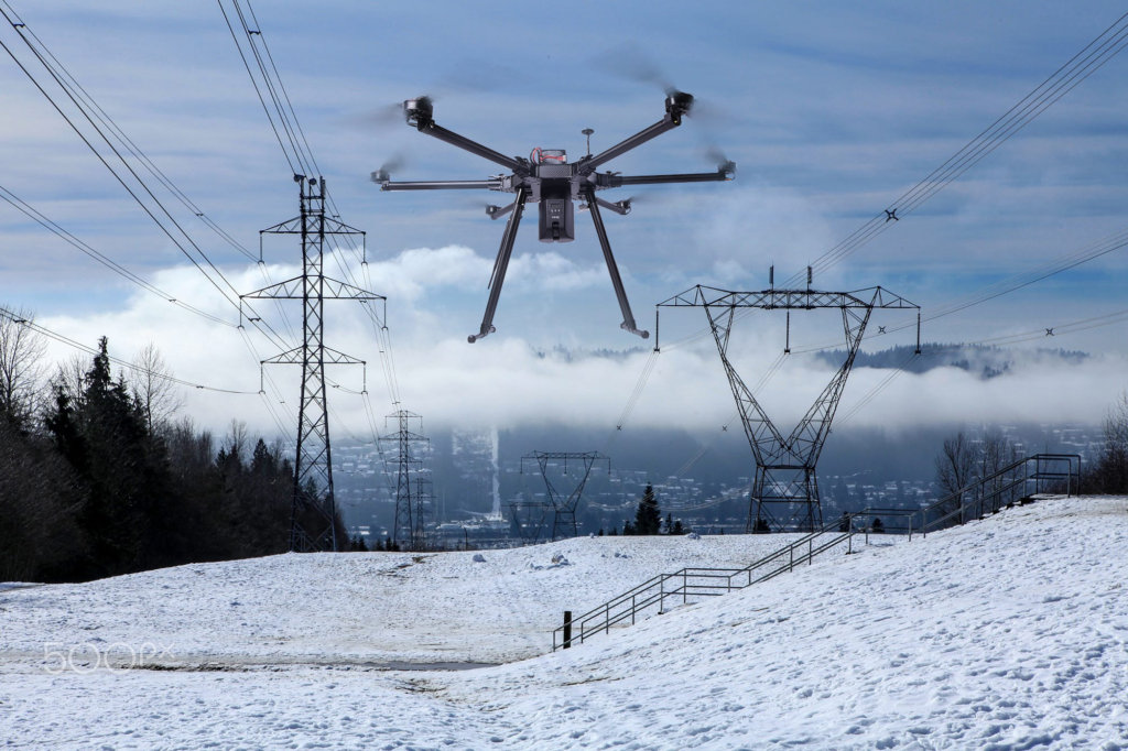
MMC, a leading provider of high end commercial drones and the manufacturer of the world’s first hydrogen-powered drone has upgraded its solution“ Spider”, the king of power line stringing solution to boost the world’s electricity production and distribution to facilitate economic growth especially for areas with varied topography. Rugged mountains, and large areas inaccessible by roads make power line stringing and inspection difficult and dangerous to do with a human workforce. So in many ways, drones are the perfect tool for power line stringing.

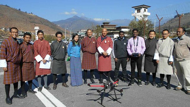
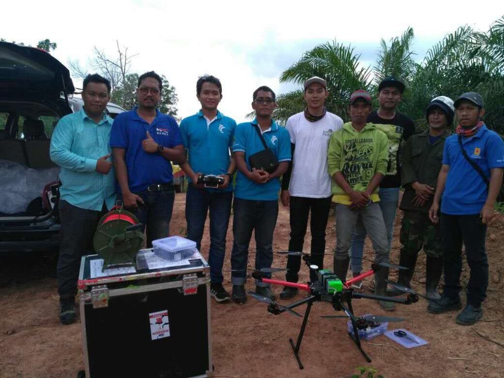
Spider, that’s a complete set of drone solution of power line stringing solution covering professional drone F6 Plus, schemes and pilots team to help finish stringing project without deforestation, damage to farmland and environment. MMC’s professional pilots team has six-year experience of power line stringing and had successful cases in Asia such as Bhutan and Indonesia. The solution has experience of power line stringing for over 300 thousand kilometers. The professional drones have flied over Kalimantan Tropical rain forest, high-altitude mountains in Bhutan, China’s island and rivers, and etc..


The drone solution Spider offers customizable features including:
Intelligent drop device mounted on the drones can avoid the problem of being intertwined by branches or hanged by human.
The drones with payloads can fly for more than 20 minutes, and complete the power line stringing project over 900 meters’ range.
The payload is up to 5 kg, and realize the bearing of standard leading line of 3mm. Users don’t have to use unprofessional leading lines such as fish wires any more.
The auto flight can be set. The switch between the manual operation and route planing can be realized to make the stringing work more stable
The wind resistant scale is grade 5, which meet the power line stringing requirements perfectly.
The Spider solution can be based on A6 Plus,which can implement tasks in the rain due to its carbon fiber materials and tightness.


7.The payloads can be turned into cameras and gimbals to change the functions and implement the inspection tasks due to its plug and play design.

So far, with the drone solution of Spider, MMC has accumulated rich experience of power line stringing project. In 2016, MMC helped KEC International Ltd to complete power line stringing project in Bhutan of high altitude after proposing scheme towards the topography of steep and high mountains crisscrossed by a network of swift rivers, which form deep valleys. Well at the same year, MMC built long-term cooperation relationship with PLN, the Indonesian State Electricity Company, MMC provides drones and training for PLN’s development team.


MMC provides a complete range of services including the free demonstration before the purchasing, training, project guidance and after-sales service to meet customers requirements. To gain the confidence of the customer, MMC can apply for demonstration before purchasing drones or enjoy the service.

MMC owned its own pilots team, with 50 pilots in China, ten in India, 5 in Indonesia. And its AOPA training center issue certificate for qualified pilots. The team at MMC fuses expertise and years of experience in commercial drone operations. This varied experience make it possible to design a solution suited to meet the needs of the most complex industrial environments.


Read more:

Tuesday, February 7, 2017

Cyberhawk Drones Make English Railways Safer

dronelife.comBY JASON REAGAN
FEBRUARY 6, 2017


A Scotland-based drone surveying firm is making British rail service safer from above.

Cyberhawk Innovations recently concluded a drone aerial inspection and survey over the Rugby rail station in Warwickshire, England – the first internal and external structural inspection for the British rail network.

The company deployed sensor-arrayed drones to capture images of the station’s supporting superstructure and roof to locate possible damage or wear. In the past, the rail network depended on ground cameras wielded by workers on high-altitude scaffolding, creating precarious safety risks.

“Cyberhawk’s UAVs allowed for a quick and safe audit of the stations roof, mitigated the need for personnel to work at height and importantly, permitted railway lines to stay open to the public throughout operations,” a Cyberhawk press release stated.

“We were awarded a framework agreement with Network Rail in 2014, which was one of the many reasons we were chosen to undertake project, along with our Congested Areas Operating Safety Case (CAOSC) permission to fly UAVs in urban areas and in close proximity to structures, vehicles and people,” Cyberhawk commercial director Philip Buchan.

“Over the past two years we have grown our portfolio in the rail sector, due to the vast benefits on offer through the use of our UAV technology. We have carried out multiple inspection and survey projects across the UK, and this project is testament to our ability to deliver more complex and challenging infrastructure inspection projects.”

In January, the company received a nomination for the UK’s Offshore Achievement Awards, in the Safety Innovations category with results to be announced in March. Cyberhawk developed drone technology for inspection and survey to improve offshore safety in the oil and gas sector.

“Cyberhawk conducted the very first [drone] industrial inspection in 2010 and since then, has built up an unrivalled track record in oil and gas,” Buchan said. “Following the launch of a new wind turbine inspection service last year, we hope to see this success replicated within the renewables sector.”

To date, the company has completed more than 200 live flare inspections for companies such as Shell, BP, Chevron, Total and Exxon.


Read more
http://dronelife.com/2017/02/06/cyberhawk-drones-make-english-railways-safer/

Monday, February 6, 2017

China Offers Air-Ground Missiles for Drones

uasvision.com
February 6, 2017


China can now offer users of its combat drones a new missile designed for anti-terrorism operations and low-intensity conflicts. The new, short-range AR-2 is perfect for mounting on drones in anti-terrorism uses, officials said.


The China Academy of Aerospace Aerodynamics, the country’s largest military drone exporter by number of products sold overseas, said it recently conducted live-fire tests on the AR-2 short-range air-to-surface missile in northwestern China.


AR-2 fired from CH-4

A CH-4 reconnaissance/combat drone was used in the tests, though the missile can also be mounted on other CH drones, officials said. The academy’s CH-series drones have been sold to military users in over 10 countries.


AR-2 Missile

The missile also can be carried by Chinese attack helicopters and other unmanned aircraft after minor technical modifications, they said.

With a weight of about 20 kilograms and a 5 kg warhead, an AR-2 has a maximum range of 8 kilometers and a top speed of 735 kilometers per hour. It is effective against personnel, armoured cars, houses or bunkers, its designers said.

Zeng Like, project manager for the AR-2, said that the academy hopes to win market share from the United States’ AGM-114 Hellfire, widely used in the 1990s and 2000s. At least 29 nations, including Australia, France and South Korea, deploy the Hellfire, according to Jane’s Weapon Systems.


“There are a lot of counterterrorism operations and low-intensity conflicts in the world that create a huge demand for low-cost, high-efficiency weapons to hit cars or light-duty, armored vehicles,” he said. “We believe that most ground targets designated for drones are soft targets or lightly armored vehicles, so using a heavier missile such as the AGM-114 Hellfire for such operations is a waste.”

Smaller, cheaper missiles like the AR-2 are powerful enough to handle those targets, and their lighter weight enables a drone to carry more missiles, Zeng said.

The AR-2′s biggest competitors are the US’ AGM-176 Griffin, currently the best-selling lightweight precision-strike weapon, France’s Lightweight Multirole Missile and Israel’s Whip Shot missile, he said.

But, Zeng said, “the AR-2 features strong capabilities and a lower price, so we are positive it will have good market prospects”.

Many of the academy’s clients now use the bigger, heavier AR-1 missile with CH drones, he said.


AR-2 and AR-1Missiles

In another development, the academy said trainees from one of its foreign clients performed a test in which four CH drones were networked to perform as a fleet.

Ground controllers from the unnamed foreign nation who were trained at the academy guided four CH-4B drones via satellite to work together in a patrol.

Huang Wei, a senior researcher who oversaw the test, said the networking of multiple drones is useful for joint operations in combat. Huang said only China and the US are capable of conducting joint operations using multiple drones.

Source: China Daily


Read more:
http://www.uasvision.com/2017/02/06/china-offers-air-ground-missiles-for-drones/

The Case for Low Power ADS-B for Drones

suasnews.com
By Press
5 February 2017


Let’s just start with a few numbers and some back of the envelope math:

1.2 million drones were sold in the United States in 2016
1,800 reported pilot drone sightings in the United States in 2016 (up 25% from 2015)

0.4 miles – about the maximum distance I can see my DJI Phantom 4 with unaided eyes
150 knots – average approach speed of a 737-800
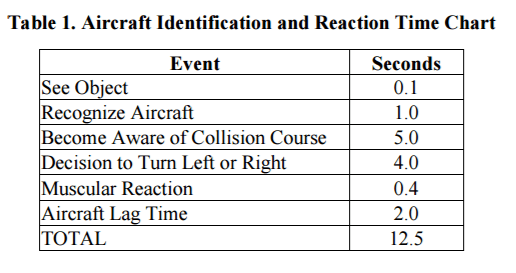
8.4 seconds – the amount of time a 737-800 pilot has to react to a sighting of a Phantom 0.4 miles away on approach at 150 knots
165 souls on board that 737-800
Just to iterate on that theme a bit with regards to reaction time:

A Cessna 172 at its cruising speed of 122 knots would have 10.3 seconds
An EMS helicopter speeding to the scene of an accident at 135 knots would have 9.3 seconds
A crop-duster spraying crops at 156 knots would have 8.0 seconds
According to FAA Advisory Circular 90-48D, Detection and Reaction Time. (pg. 2)


“Research has shown that the average person has a reaction time of 12.5 seconds.”


FAA-90-48d-pilot-reaction-time
ADS-B: ‘See and Be Seen’

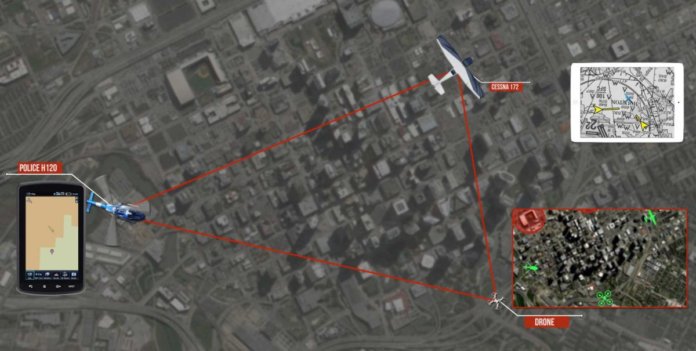
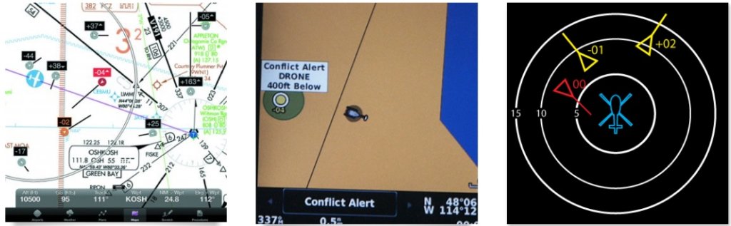
I’m guessing that if you’re reading this post, you probably have an idea of what Automatic Dependent Surveillance – Broadcast (ADS-B) is. But just to give a very brief description – ADS-B is an internationally standardized aviation technology that is mandatorily being installed in airplanes and helicopters worldwide. Very simply, the ADS-B avionics onboard the aircraft announces its own identification, position, altitude, and direction – for all the world to hear. Who is listening? Air Traffic Control (ATC) for one – it’s a significant improvement over legacy radar technology. But who else can hear? – any other airplane within tens to hundreds of miles around – and all those little airplane icons can be plotted on a map in their cockpit or on their ipad or other mobile devices. It looks like this:


Problem Solved?

“WOW – This sounds perfect for drones!” you might say. “If all the drones have ADS-B, and all the airplanes have ADS-B – then everyone can see each other and stay out of each other’s way!”

Well, it turns out that the concept is a pretty great, but it’s not a perfect solution. In fact, if implemented poorly – it could be a very bad solution. We at uAvionix want to make sure it gets implemented the right way. In fact, we are passionate in our belief that this technology will save lives.

Objections

Let’s quickly list the arguments against ADS-B for drones, and we’ll dig into the details of the last one a bit – which deals with the subject matter in the title of this post.

“The technology is too big for drones!”

Not anymore. Just browse our product listings and you’ll see we have products that range from 5 grams to 70 grams. We have some products even tinier that we can’t sell for the reasons described later.

“The technology is too expensive for drones!”

This is a function of supply and demand. Prices can and will come down with volume.

“Not every airplane/helicopter has to have ADS-B onboard, so it’s not a 100% solution”.

True statement, but the majority will, and with dropping prices – more will voluntarily equip. Turns out we’re working that angle as well – but that’s another blog post for another day.

“LTE/5G will be a better solution for tracking drones.”

There is no doubt that these technologies will have a critical role in connecting the future fleet of drones – but defining a standard that the whole drone industry will adopt, and more importantly somehow driving that visibility into the manned aircraft cockpit will take many years. 1,800 pilot drone sightings last year. We need something now.

“ATC doesn’t want to see all those drones on their screens!”

This one gets a little technical – but those displays have the capability to filter out things they don’t want to see – like really low-altitude drones in uncontrolled airspace. They can do this today. And you can bet they DO want to see drones on an approach path to a runway.

Those are actually the trivial arguments – this last one is the more complex one:

“If all the drones that are predicted broadcast ADS-B – there would be so many ADS-B messages bouncing around the skies that it would flood the airwaves and the whole system would come crashing down and be unreliable.”

This is the one that scares the FAA and other regulatory bodies – and it’s a true statement. But there are a lot of assumptions in that statement that can be mitigated with some very practical measures. Let’s break it down:

“If all the drones…”

I haven’t heard anyone advocating for “all the drones” to broadcast ADS-B. The practical measure here is to limit ADS-B to only drone operations that are pretty risky – like those flying beyond visual line of sight (BVLOS), or in controlled airspace for example. If following this rule, NONE of the drone operations conducted under Part 107 would require ADS-B equipment.

“…that are predicted…”

The numbers being used here are pulled from a recently published study that included a simulation that placed 14,000 small drones all under 500 feet AGL simultaneously within a 32-nautical mile diameter. That is a LOT of drones – and we don’t know when or if we might ever get there – but we do know it’s not this year or next – maybe not for 10 years or more. In the meantime, 1.2 million drones were sold in the U.S. in 2016. We have time to implement a safety measure now, and adjust as we go along.

“…it would flood the airwaves…”

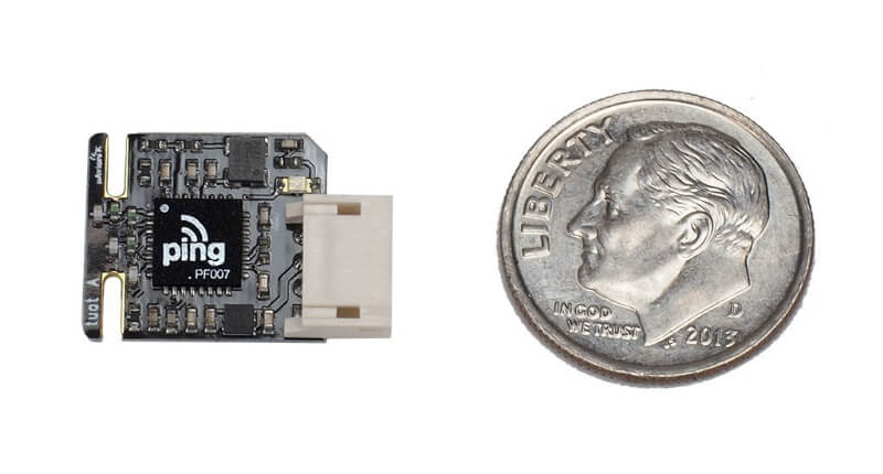
Here’s the good stuff. That same study suggests that there is a nominal transmission power output between 0.01 and 0.1 Watts that when coupled with limited drone traffic densities can result in a compatible operation with the system as a whole. Whoa – that got technical fast – what that statement means is there is a REALLY low power output for ADS-B transmissions that if implemented on drones won’t “flood the airwaves” and crash the system. By the way, those power ranges mentioned would give other aircraft the ability to see the drone from 1-5 miles away on their cockpit screens. And if you’re wondering – yes – it’s technically possible to build one that small. We’ve done it – and here it is:


Ping Tiny UAT ADS-B for UAS

“HOORAY! Let’s just do that!” If only …. the problem is that the technical standards that were written for ADS-B many years ago didn’t have drones in mind, and therefore the power ranges specified in those standards range from 7 Watts to 350 Watts, the upper end providing visibility for hundreds of miles – necessary for big aircraft at high altitudes being watched by ATC. Therefore – it’s not legal to transmit at low power settings that would prevent the very thing everyone fears.

A way forward

So here we are. A technical solution is among us that increases safety today. It has been confirmed by smart people at a credible source which happens to have an advisory role to the FAA. But while it is legal to broadcast ADS-B from drones today from 7-350 Watts – contributing to “flooding the airwaves,” it’s literally illegal to broadcast at a power setting that still provides the safety margins needed, but at a comparatively minuscule power setting that preserves the integrity of the whole system.

We need our regulators to identify this as an opportunity for a quick standard that can be developed, released, and required on those most risky of drone operations.

Let’s do this.

If you want to read that really technical study by some really smart people at a credible source (MITRE Corporation) – you can find it at www.mitre.org. It’s called “ADS-B Surveillance System Performance with Small UAS at Low Altitudes”

Christian Ramsey VP Business Development – uAvionix


Read more:
https://www.suasnews.com/2017/02/case-low-power-ads-b-drones/

Thursday, February 2, 2017

Agricultural Drones Can Save You Millions


droneblog.com
By Droneblog Editor
February 1, 2017


According to a study conducted by Informa Economics and Measure, corn, soybean and wheat farmers could save an estimated $1.3 billion dollars annually by utilizing drones. The report claimed that the biggest beneficiaries would be corn farmers as they could save a huge $11.58 per acre and could see an increase of crop yields by about 3.3 percent. These incredible statistics might sound too good to be true, but we are here to let you know that agricultural drones really do have amazing features that can save you lots of money.

Drones have really come a long way since when they were first designed. Originally built for surveillance and military operations, these unmanned aircraft have found many different uses over the years. An incredible way of accumulating intelligence in an area too dangerous for men and women, they can fly into enemy territory and provide incredible video footage of possible threats. They have then been modded and redesigned for more recreational use. Drones have now found their way into people’s homes, they make brilliant gifts for anyone looking for a fun and exciting flying experience. As soon as they became widely available to the public, people began to see the potential in drone racing. This has now become an incredibly exciting sport, going from strength to strength and gaining more and more attention from all over the world. Feel free to read more about drone racing here. However, one of their more surprising uses is in the agricultural world. Robust, intelligent and packed full of hi-tech features, agricultural drones have the ability to make a farmer’s life easier and we are here to explain why.


WHY DRONES HAVE MADE SUCH AN IMPACT IN AGRICULTURE

There are many reasons as to why drones have had such a positive impact in the agricultural industry. Farming is truly back-breaking work, early hours and long days make for a hard day’s work, so the invention of something that can help lighten the load will always be welcome within the farmer community. Agricultural drones not only help with the workload but can actually help boost a farm’s performance. Although it sounds too good to be true, it really isn’t and we are here to show you why this is indeed true.


CROP SURVEILLANCE

Ensuring the health of a crop is, of course, an absolute priority for any farmer. A more unorthodox way of monitoring a crop is by using a drone’s camera abilities. A drone measures a crops health by looking at changes in visible light and near-infrared light reflected by the crops. Depending on how healthy they are, plants reflect different amounts of visible green and near-infrared light.

Viewing this from the air provides the user with the chance to expose any possible problems which can’t be seen from the ground, such as pest and fungal infestations. Another fantastic feature on an agricultural drone is the infrared camera feature. This, combined with the normal images can perfectly highlight any differences between healthy and unhealthy plants, which can’t always be seen by the naked eye. There is also a converter in the camera, if it has been upgraded, which can measure the NDVI (Normalized Difference Vegetation Index) of a crop, giving an incredibly precise and detailed image of the density and health of the vegetation. Not only this, but some drones also have an ultraviolet image setting meaning the farmer can see another level of distress in the plants.


THERMAL SECURITY

A truly sad fact is that, in South Africa, there are so many farm murders each year that farm security needs to be a top priority. Not only to protect your crops and produce but also to protect yourself and family from any possible harm. A huge benefit of agricultural drones is that they are equipped with thermal imagery. Using temperature, thermal drones can detect humans or animals in a crop that could be hidden from sight. Having a drone that not only helps to look after your farm but also protects it is something that all farmers could really benefit from.


THE VIEW

It may seem obvious, but a drone can provide views of the farm that the owner may have never seen before. Not only do they display an incredible aerial view, but also record in HD, meaning the farmer can watch the high-quality footage as much as they want and find out where needs work.


DRONE MAPPING & CROP DUSTING

Agricultural drones have the ability to dust crops on a completely unique and bespoke path. Working through an autopilot feature, once the drone’s flight path has been mapped out it can be left to its task, which it will then do efficiently and effectively. Prescription maps are also there to inform the farm owner what the farm needs, such as increasing or decreasing nitrogen spread on unhealthy spots. Drone mapping has the potential to improve a farm’s productivity and ensure that only quality and healthy crops are grown. It has also never been easier thanks to the Drone Deploy app, available for Iphone and Android users. Free and easy to use, the app perfectly captures data any farmer needs and includes 3D modelling and high-quality interactive maps. Compatible with the latest DJI drones, it allows the user to fly autonomously with just two taps of their phone.

So, if you are thinking of getting a drone to help with your farm then a drone which perfectly combines all of these features is the DJI AGRAS MG-1. Purpose-built to deliver maximum efficiency, reliability and longevity, it can cover 7-10 acres an hour and can carry up to 10kg of liquid payloads. Its speed and power allows it to effectively cover an area of 4,000-6,000 m² in just 10 minutes which is up to 60 times faster than manual spraying options. Not to mention the Phantom 4 and the Phantom 4Pro + with DroneDeploy which is perfect for mapping. Powerful, reliable and advanced, the Phantom 4Pro boasts a sharp 4K camera and a 5-direction obstacle sensor, which makes it intelligent enough to navigate its way through any kind of farm. DJI are famous for making some of the best and most impressive drones around, and that is no different with any of these.

Agricultural drones are there to not only help lighten the workload on a farm but also increase the amount of produce. If you have any questions on how these can help you, please feel free to get in touch with us by either email or phone:

Phone: 0215512648
Cell: 0834638310
Email: info@smashtronics.co.za


Read more:

Tuesday, January 31, 2017

APB – Drones Meet Law Enforcement in Fox Crime Drama


dronelife.comBY MALEK MURISON
JANUARY 30, 2017


APB, a new crime drama launching on Fox later this month, offers an interesting and fairly realistic prediction of how drone technology could be applied in the world of law enforcement.

Gideon Reeves is a billionaire used to getting what he wants, when he wants it. That much is clear in a matter of minutes. He’s also the CEO of a leading technology company and knows a thing or two about drones. When a close friend is murdered in front of his eyes and the Chicago police are nowhere to be seen, he decides to take matters into his own hands. After publicly cornering the city’s mayor, he takes control of policing in Chicago’s struggling 13th district and digs deep into his own pockets to give the force a much-needed high-tech makeover. That’s where the drones come in.


Although the series starts with an exhibition of Reeves’ latest drone, designed to stem the flow of oil well fires and somehow capable of 36 hours of flight time, it’s when he makes the move into law enforcement that things get interesting. Plenty of drone enthusiasts and police men and women will enjoy the plausible look at how drones could be used to fight crime in the years to come.

Want to read about what’s really going on with drones in the world of law enforcement? Check out these articles:
3 Ways Police Are Using Drones Around the World
Will Taser Stun Drones Fly With Police?

Everything you’d expect from APB is present, along with a little of what you might not have considered before. Drones that look suspiciously similar to the DJI Inspire 1 are dispatched to keep track of perps’ on the run, while it’s not long before Reeves decides to arm them with tasers, too.

Drone fans will also enjoy seeing a prime-time tv version of a moment many pilots will have experienced: the dreaded loss of signal and the inevitable crash that follows.


APB, FOX’s new cop show with a twist, will be premiering on Monday, February 6th at 9pm ET/PT, and will continue to air on Mondays at the same time. It looks to be an entertaining series, especially if you’re into drones, arrogant but entertaining billionaires meddling where they shouldn’t, technology trends and generally looking forward at how UAVs can be applied to help make police work easier.


Read more:

Sunday, January 22, 2017

Free online seminar explains the cost and process of drones in agriculture


dronelife.com
BY MIRIAM MCNABB
JANUARY 19, 2017


With the clear benefits that agronomists get from a birds’ eye view of their crops, precision agriculture has been one of the leading applications of drones across the globe. The technology offers incredible advantages: with the data provided by drones farms of any scale can conserve resources, monitor crops, make better predictions, and save money.

But in precision agriculture as with many commercial drone applications, companies can be hesitant to invest in new technology without a clear understanding of the cost benefit. Now, with their line of commercial drones having flown more than 300,000 flights and 90,000 hours over more than 30 million acres, senseFly will host a webinar to lay it out clearly. senseFly, the Parrot company behind the lightweight professional eBee drone, will host the free webinar at 10:00 EST/16:00 CET on Tuesday, January 24. “The information shared during this webinar will help those in agriculture understand the value drones can bring to their business,” Nathan Stein, senseFly Ag Solutions Manager, tells DRONELIFE.

During this event, experienced operators from two of the ag market’s agronomy leaders—AIRINOV (France) and Deveron UAS (Canada)—will discuss their companies’ drone use, including the opportunities and challenges that adopting this technology brings. Attendees must register in advance for the one-hour webinar, entitled Ag Drone Insights – Experienced Agronomists Discuss UAV Results, Costs, Workflows and More.

“Across the globe, agronomists, growers and researchers are increasingly using drones to gain deeper insights and to optimise their operations,” said senseFly’s CEO, Jean-Christophe Zufferey. “This webinar will help professionals who have yet to adopt UAV technology to more fully understand how and when drones can help drive their businesses, and those of their clients, forward.”

Topics covered in the webinar will include:
· How to choose, adopt and operate ag drone technology
· The different drone applications possible — from scouting to irrigation planning
· How to manage drone data and transform this into marketable products
· The real cost of ag drone ownership
· The impact of drone regulations on doing business
· How to build a scalable business based on drone generated imagery

Entrepreneur and farmer Norm Lamothe, head of UAS agriculture at Deveron UAS, will demonstrate how Deveron UAS employs drone tech across eastern Canada to more accurately analyse the health of its clients’ crops, optimise their applications, predict yields and identify issues such as disease and infestation.

Agricultural engineer Erick Lebrun, communications manager at AIRINOV, will discuss how AIRINOV combines its expert crop insights with data from senseFly fixed-wing UAVs to help its customers produce more and optimise their time. For example, he will detail AIRINOV’s work with OCEALIA Groupe, a large French farming cooperative, whose farmers have benefitted from a 10 percent yield increase since employing AIRINOV’s drone-based consulting services.

In addition, senseFly will provide a glimpse into the company’s newest advanced agricultural drone, the eBee SQ.


Read more at:

Thursday, January 19, 2017

How Drones Are Helping Construction Companies Make & Save Money

suasnews.com
By Press
18 January 2017


The construction industry has proved ripe for disruption by drone technology. The reasons for this can be difficult to pick apart. An important factor is that the business of construction—both commercial and residential—is highly complex and involves many skilled workers involved at different phases. Each of these phases can be broken down further into niche tasks, each requiring safety oversight, monitoring, and data collection. The result is a long, expensive, complicated process, with many opportunities for increased efficiency.

Early adopters of drone technology saw opportunities to make money by offering ways to make old processes faster, cheaper, and simpler—but they often focused on just one or two uses cases. For construction and engineering firms, there are likely dozens of ways to use drones in order to maximise your investment and run more efficiently and safely.

In this article, I’ll focus on ways that drones can be used in the design, building, and marketing phases of a construction project.

Using Drones in Design & Engineering


The planning, surveying, architecture, and engineering that go into shaping what eventually become a construction job all rely on good data. Using drones to capture images of the land is only the beginning of the value that they can offer a construction firm. By gathering that raw sensor data and feeding it into software like Skycatch, DroneDeploy, or InfraWorks, you have created value that can be packaged and sold under various pricing structures.

Though these applications are powerful, they cannot fully replace surveying. But by combining drone data and standard surveying tools, you can offer clients a wider range of services, such as the ability to measure how much cut and fill they will need in order to make the ground level enough to build upon.

Or you can create a 3D rendering of the site, and then create a layer for each stage of building, show how the project will progress and helping to identify potential problems. Without drones, these tasks might require hiring a plane or helicopter, as well as a staff of data scientists. Drones provide the opportunity to offer these services at a more competitive rate, and with the bonus of gathering the data safely. And speaking of safety.

Drones on the Construction Site

Imagine your client needs to inspect the welding on the thirteenth floor of a structure. They could hire a crane and send personnel up there, or they could fly a UAV and accomplish the same goal cheaper and faster without the risk of having a person working at height, no matter how mitigated that risk might be.

As a bonus, a supervisor or engineer on the ground can receive HD footage in real time, which would not be possible with a human worker. This example is, in miniature, why drones have been so readily embraced by the construction industry. Here are a few other use cases for drones on the construction site.

Time Lapses: You can use drones to take weekly images of the structure, and then stitch them together into a time-lapse video. This can help in coordinating logistics among the many parties involved, while also updating remote stakeholders about the progress. Many executives would be willing to pay for an easier way to visualise their daily ops.

Job Site Monitoring: There is huge potential here. As it stands, flying a UAV over people is not allowed without a permit, but the FAA works with applicants who are willing to prove their processes are safe (and who have proper liability insurance). You can sell clients on cutting down waste and improving the security and safety of their projects.

Thermal Imaging: Drones can be outfitted with a wide array of sensors that can see far beyond what the naked eye allows. When a building is close to completion, a drone with a thermal sensor can fly overhead and identify cold and hot spots, areas that might either need additional HVAC infrastructure or could pose risks of electrical fire.

These are only a few use cases, and many more applications are in development or already in use.

Using Drones for Marketing

Of course, aerial photography and video for residential and commercial real estate marketing are one of the best-known applications for drones today. Rather than hiring a crane or helicopter, many firms are choosing to spend far less by hiring a drone with a high-quality camera and a capable pilot. The results speak for themselves. With a drone, you can achieve unusual angles, take a greater number of photographs, and achieve results that would otherwise be impractical or impossible. This creates a competitive advantage when it comes to promotional photography.

Here’s another exciting use case in the realm of marketing: a drone can take photos showing what the view will look like from any given office – even before that office is built. By pinpointing the position and elevation of a space, a drone can fly to those coordinates and snap a picture. This is unfeasible with older technologies, and serves to get the wheels of commerce spinning at an earlier stage.

These are just a handful of ways that you can harness drones to generate income for your construction firm. As time goes on, the number of companies that embrace this technology will grow as they see the rewards being reaped by early adopters. If you’re interested in incorporating drones into your construction business, read our earlier article on some of the challenges you might face and how to avoid them.

Annie Norris Skyward Drone Ops Consultant Skyward


Read more at:
https://www.suasnews.com/2017/01/drones-helping-construction-companies-make-save-money/

Monday, January 16, 2017

Report: LiDAR Drone Market Will Soar into 2020

dronelife.comBY JASON REAGAN
JANUARY 13, 2017


LiDAR sensors and drones go together like PB&J and an industry report paints a rosy picture for both industries.

“Global market intelligence company” Transparency Market Research released a study last week predicting an increase in the Light Detection and Ranging market as it relates to drone combos.

Following the explosion in drone adoption across precision industries such as mining, construction, utility, inspection and agriculture, sales of sensors ranging from thermal to sonar to LiDAR have soared. The market is expected to rise to $1 billion by 2020 – an increase of 20 percent.

As explained in a previous DRONELIFE report: “[LiDAR] is used to measure distances from the sensor to the object by calculating the time between the release of laser pulse to time the reflected pulse is received.” The data obtained from the laser pulse can detect pollutants and gases as well as produce precision elevation maps.

“The global LiDAR market is also significantly gaining from the rising demand for laser scanners. These scanners exhibit high wavelength and are used for making clear 3D models for surveyed areas,” the Transparency report states. “Based on application, the corridor mapping segment has emerged dominant in the market due to rapid urbanization and increasing construction of highways, roadways, and railways.”

The report also points out the growth of LiDAR drone markets could be stymied by a lack of pilots trained to operate sensor-loaded drones. NOAA offers a non-certified online program that is “introduces several fundamental concepts of LiDAR and demonstrates how high-accuracy LiDAR-derived elevation data support natural resource and emergency management applications.”

The rotary drone sector is expected to outpace the fixed-wing market when it comes to LiDAR-related sales, the report notes. “The design of rotary wing LiDAR enables easy access to confined specs such as bridges and pipeline, due to which it is preferred for monitoring and inspection applications.”

Companies such as LeddarTech have leveraged the growing demand for drone LiDAR sensors. DRONELIFE columnist Colin Snow notes that the company’s release of the modular Vu8 could be a “perfect solution for autonomous drone use.” The compact sensor – weighing in at 75 grams – can detect targets up to a range of 705 feet and the company says it can produce “highly accurate, multi-target detection over eight independent segments.”


Read more at:
http://dronelife.com/2017/01/13/report-lidar-drone-market-will-soar-2020/

Wednesday, January 11, 2017

THE PENTAGON'S NEW DRONE SWARM HERALDS A FUTURE OF AUTONOMOUS WAR MACHINES

popsci.com
By Kelsey D. Atherton
January 10, 2017


On Oct. 26, 2016, a pair of Hornets flying above an empty part of California opened their bellies and released a robotic swarm. With machine precision, the fast-moving unmanned flying machines took flight, then moved to a series of waypoints, meeting objectives set for the swarm by a human controller. The brief flight of 103 tiny drones heralds a new age in how, exactly, America uses robots at war.


The Pentagon’s worked with Perdix drones since 2013, with the October flight using the military’s 6th generation of the devices. F/A-18 Hornets, long-serving Navy fighters, carried the drones and released them from flare dispensers. The small drones were the subject of an episode of CBS’s 60 Minutes, and they move so fast they’re hard to film. Below, in a clip from the Department of Defense, the drones are barely visible as dark blurs beneath the fighters.


Captured by telemetry video on the ground, the swarm is clearly visible. First it appears as if from nowhere, moves as one towards a new set of objectives.


This drone swarm was a product of the Strategic Capabilities Office, and outgoing Secretary of Defense Ash Carter praised the work, saying “This is the kind of cutting-edge innovation that will keep us a step ahead of our adversaries. This demonstration will advance our development of autonomous systems.”

Autonomy and swarming are centerpieces in many predictions about the next century of war. The Predator, Reaper, and Global Hawk drones that have so far most embodied how the United States fights wars are big, expensive, and vulnerable machines, with human pilots and sensor operators controlling them remotely. These drones also operate in skies relatively free of threats, without fear that a hostile jet will shoot them down. That’s an approach that’s fine for counterinsurgency battles, an admittedly large part of the wars the Pentagon actually fights, but against a near-peer nation or any foe with sophisticated anti-air or electronic jamming equipment, Reapers are extremely vulnerable targets.

Swarms, where several small flying robots work together to do the same job previously done by a larger craft are one way around that. A few $45,000 anti-air missiles are a cost-effective way to shoot down an $18 million Reaper, but firing that same anti-air missile at a smaller, commercial drone isn’t as effective, especially when there are still 102 other drones flying the same mission at the same time.

Controlling that swarm is where autonomy comes in. With every Predator drone, there’s an actual joystick and flight controls for a human pilot, whose job it is to direct the uncrewed plane and maneuver it. That one-to-one ratio would be impossible to maintain with a small drone swarm, and given that the perdix drone has a listed flight time of “over 20 minutes,” it would be a lot of effort for a very short excursion.

“They are a collective organism, sharing one distributed brain for decision-making and adapting to each other like swarms in nature,” according to Strategic Capabilities Office Director William Roper, before emphasizing that there was a human in the loop. Unlike the Predator, where the machine responds to the pilot’s joystick, this swarm receives objectives from a human controller, and then directs itself to that location. Presumably, the swarm could still fly to a preset list of objectives even if it loses contact with a human controller, giving it the freedom to operate in the face of jamming as well as anti-air weapons.

For now, the autonomous decision making appears limited to where it flies. The Pentagon’s Defense Science Board released a study on military uses of autonomy in the summer of 2015, and mostly found nonlethal uses for self-directed machines. Still, it’s not hard to picture a future where similarly small drones with explosive payloads could receive a command to fly to a given point, and then once there crash into the objective. Developing autonomy is the hard part; turning it into a weapon isn’t. The international community is already considering bans on lethal machines, though deadly machines with some degree of autonomy are already here.

Perdix, as it is, is a breakthrough for autonomy and for swarms, not for lethality. For now, we can admire the maneuvering buzzing swarm of skybots, while still wondering how much human control, exactly, is in the process.

Watch and especially listen to the swarm below. “Drone” has rarely been a more appropriate descriptor.

TAGS:
DRONES
UAVS
DRONE SWARMS
AUTONOMY
AUTONOMOUS MACHINES
PENTAGON
MILITARY


Read more at:
http://www.popsci.com/pentagon-drone-swarm-autonomous-war-machines

Tuesday, January 3, 2017

Drone Companies Flying High Across Construction Sector

dronelife.comBY JASON REAGAN
JANUARY 2, 2017


Loaded with state-of-art sensors and backed by unprecedented software analysis, drones are building a better future for the construction industry.

Goldman Sachs projects construction companies will lead the way in adopting drone technology with a myriad of uses from surveying new projects for defects to patrolling construction sites for bad guys.

According to a recent report by the Association for Unmanned Vehicle Systems International, the FAA had granted more than 1,800 exemptions to the infrastructure and construction industry, comprising 60 percent of requests across all sectors.

The survey also found 41 percent of the largest construction firms say they will very likely use drones in the future.

As the sector continues to bloom, several drone and drone-equipment players have made key strides in building on the construction boom.
DJI-Datumate

DJI, the world’s largest drone manufacturer, recently partnered with geomatics software maker manufacturer Datumate to create a software and app surveying package. The suite can automate construction site surveys, giving firms quicker and more in-depth results.

The companies are marketing the package as “Triple D” bundles – mating a DJI drone with Datumate’s DatuFly tablet app and its DatuGram 3D photogrammetry software that converts images to high-precision, geo-referenced 2D maps and 3D models.
University of Illinois

The University of Illinois team recently launched the “Flying Superintendent” – a set of predictive, visual data analytics tools, tasked with automating several tasks in the field of construction progress monitoring.

Like DJI-Datumate’s package, the Flying Superintendent integrates both images and videos shot by drones and “four-dimensional Building Information Modeling (BIM) to quickly identify and visually communicate the actual and potential performance problems during execution of construction projects via smartphones and tablets to project participants, on and off site,” according to a UI press release.

Far from just an academic effort, the team is working with Turner Construction to unleash the analytics powerhouse at the Golden 1 Center – the new home for the Sacramento Kings.
Eos

Canadian firm Eos Systems recently launched PhotoModeler UAS 2016, a photogrammetry software package that can be customized for construction projects.

The suite creates 3D imagery, maps and measurements from images transmitted via drone and integrates them with full geographic coordinate systems support.

PhotoModeler features post-processing kinematics (PPK), volume objects, full geographic coordinate systems support, multispectral image support and control point assistance.

In addition, PhotoModeler can correct a drone-driven survey mission with GPS data for greater accuracy

In addition to launching innovative solutions, the drone industry is working with the construction and insurance industries to establish best safety practices. The Property Drone Consortium includes charter members Allstate, American Family Insurance, Auto-Owners Insurance, EagleView Technologies and Erie Insurance and Pilot Catastrophe Services. The PDC will develop “standards and specifications for the safe use of unmanned aircraft system technology in the insurance and construction industries.”


Read more at:

Monday, January 2, 2017

Will ADS-B transponders herald the next era for drones?


thedigitalcircuit.com
By Scott Simmie

December 30, 2016


The skies of the future are going to be busy – with a mixture of manned and unmanned vehicles sharing increasingly crowded skies. Whether it’s Amazon Prime Air, ZipLine, or a professional cinematographer with a DJI drone high in the sky, there are going to be more things flying in this “integrated” airspace than ever before.

There’s no shortage of startups with some bold ideas about how this integration might occur, using a sophisticated blend of hardware and software that can handshake with the existing air traffic control network.

It’s such a big deal that NASA is in charge of looking at how things might unfold. In fact, the agency has been examining this issue since at least 2011. Take a look at this graphic from 2014, which gives you a hint of the complexities involved:


As the graphic says, this ambitious project is known as Unmanned Aircraft Systems (UAS) Integration in the National Airspace System (NAS) Project. And the good news is that in NASA’s mind there is absolutely no question this system will happen.

“The UAS in the NAS project envisions performance-based routine access to all segments of the national airspace for all unmanned aircraft system classes, once all safety-related and technical barriers are overcome,” reads the 2014 document.

Back in 2012, the FAA Modernization and Reform Act was signed into law. It provided some pretty specific guidelines for integrating small aircraft (less than four pounds) quickly, with a goal of integrating larger UAS weighing up to 55 pounds by 2015.


NOT SO FAST

As often happens, things take a little longer than planned. And it’s easy to to see why: Putting unmanned vehicles into the skies – or at least into the skies where manned aircraft fly – must be handled very carefully. Though there have been no verified serious collisions between manned aircraft and UAS, it’s obviously something regulators, pilots, passengers – everyone – wants to avoid.

uAvionix image of how its ADS-B system provides situational awareness of airspace


The recent Part 107 rule in the US opened up the skies to commercial operators who can pass a test and are willing to follow some basic common-sense rules: Stay away from airports and flight paths, don’t fly over people or traffic, don’t fly at night unless you’ve obtained special permission to do so, etc. In other words, use common sense and have the requisite skills and knowledge to fly.


So far, so good.

But that’s not really airspace integration; it’s actually more like airspace segregation, where regulations are set in place to ensure UAS will not be near manned aircraft except with special permission, for special reasons, and with additional precautions. And, for the moment, that also makes sense.


COMPLEX TASK

Really, when you think of it (and certainly when NASA and the FAA think of it), a lot of separate cogs have to operate seamlessly in the new machine. A few of the many items on the agenda include:
  • Ensuring that UAS frequencies don’t interfere with manned aircraft
  • Ensuring that UAS vehicles and their avionics meet stringent airworthiness criteria
  • Having redundant systems to reduce the possibility of in-flight failures
  • Integrating the tracking of UAS into the regular air traffic control system
  • Perfecting a highly accurate, likely autonomous, sense-and-avoid system to avert potential collision
  • Test, evaluate, tweak, improve
  • Implement

That’s a lot of stuff – and NASA is now very involved (with a lot of partners) on a project called UAS Traffic Management System (UTM) for drones flying at lower altitudes. Between that and other technical developments, things are accelerating. And there’s a growing sense that true integration is coming before very long.


SIZE MATTERS

Part of the reason behind that is due to great (and tiny) leaps and bounds in the miniaturization of a specific piece of technology. It’s something called the ADS-B transponder, meaning Automatic Dependent Surveillance – Broadcast.

It’s a piece of gear required on manned aircraft flying in specific airspace categories – and which will become mandatory on all aircraft by 2020. We won’t go into all the details of this FAA graphic, but it gives you a good sense of how the skies are broken up into specific airspace groups, each with their own specific rules.


Transponders are already required in many categories of airspace. They will be mandatory on all aircraft by 2020. FAA Image


The technology determines an aircraft’s position in the sky, and broadcasts that location at regular intervals. It also can carry a unique identifier for that particular aircraft, so people manning ground stations or air traffic control (or other pilots) can see who’s who – and where they’re heading.

For smaller UAS, the issue in the past has been size and weight. ADS-B transponders had been built for manned aircraft, too large and heavy for small drones.

Now, several companies are manufacturing ADS-B units that can be placed (and are being placed or tested) on small unmanned aircraft. One of those companies is uAvionix, at the forefront of shrinking critical avionics components.


The demand is great. The uAvionix website points out more than 600,000 UAS were registered in 2016 – double the number of manned aircraft.

“Current radio solutions are bulky and expensive to build,” says its site. “Modern processes and silicon can reduce the size, weight and complexity of aviation safety systems.”

uAvionix builds a series of devices under the brand name “ping.” They include transponders, transceivers and navigation sources. One model, the ping 200s, is billed as “the world’s smallest, lightest, most affordable and FCC approved full range Mode C and Mode S ADS-B transponder. At just 50 grams, it implements ‘Sense and Avoid’ for Drone operations in the national airspace,” says the website.

A uAvionix ADS-B transponder that weighs but 50 grams. uAvionix Image


“Autopilots can use Ping data to plot the current course of an inbound aircraft and avoid it miles in advance of a near-miss,” it says. “Manned aircraft and air traffic control can ‘see’ ping equipped drones on screen in the cockpit and the tower.”

In fact, a video on the site shows some of the ping gear mounted on a DJI Matrice. DJI is one of several partners working in collaboration with uAvionix, including NASA, NavCanada, the FAA, Draganfly Innovations, and more.

The ping series does not require a 3G or 4G connection. But it has dawned on TDC that the new Inspire 2 is equipped for a 4G dongle, which might well be put to use for some sort of tracking or ADS-B-type use in the future – especially with the SDK open developer’s kit.


The I2 is pictured here with a Zenmuse X5S. You can also see the small FPV camera above it, in this pre-production model. Photo by Chris So, The Digital Circuit


We have no idea whether this will ever come to fruition on the I2 or not. But TDC is certainly confident the next generation of high-end drones (and certainly some of the current models) will be ADS-B capable – with a simple retrofit of currently available uAvionix devices.


The new smaller avionix gear can be easily integrated into existing flight controllers, such as the popular pixhawk. uAvionix Image


That’s one small step for miniaturization – one giant leap for safe skies.


Read more at:

US Army Researchers Demonstrate 3-D Printed Drones


uasvision.com
January 1, 2017


US soldiers witnessed the innovation of Army researchers recently during flight testing of 3-D printed unmanned aircraft systems that were created on-demand for specific missions.

The U.S. Army Training and Doctrine Command invited engineers from the Army Research Laboratory to Fort Benning, Georgia Dec. 1-3, to showcase new technology at the Army Expeditionary Warrior Experiments, or AEWE.

“We’ve created a process for converting Soldier mission needs into a 3-D printed On-Demand Small Unmanned Aircraft System, or ODSUAS, as we’ve been calling it,” said Eric Spero, team leader and project manager.

With this concept, once a patrol requires UAV support, Soldiers input all their requirements into mission planning software. The system then knows the optimal configuration for the aerial vehicle and it’s printed and delivered within 24-hours.

“We thought they’re not going to think that’s fast enough, but, actually it was the opposite,” Spero said. “The timeline of 24 hours to receive a mission-custom UAS fits right in line with the way they plan and execute their missions.”

Researchers said they felt the combination of 3-D printing and UAVs was a natural technology solution.

“Drones or quadcopters are really getting big right now, I mean in particular just the commercial and hobby markets have shown what can be done with a small amount of money,” said John Gerdes, an engineer on the project. “Additive manufacturing or 3-D printing has become huge and everybody knows all the great things that can be done with 3-D printers. So we figured let’s assemble these two new technologies and provide a solution to Soldiers that need something right now and don’t want to wait for it.”

The team spent many hours flight testing and verifying the designs and to make sure everything was going to work the way they expected.

“It was good that we didn’t have any mistakes on game day,” said fellow engineer Nathan Beals. “The day before we did some test flights and worked out some kinks. I think we had the quad up to 55 miles per hour.”

Spero said based on feedback from Army leaders, his team hopes to work on low noise, long standoff distance, heavier payload capacity and better agility.

I’m very optimistic that most of those are achievable. I think the hardest one that’s going to be achievable is the heavy payload.

Soldiers at AEWE also became fascinated with 3-D printing technologies, Spero said.

“Before we even started the briefing, we set up the 3-D printer in the conference room and started a print job,” Spero said.

The researchers printed a Picatinny Rail, which is a bracket used to mount accessories on a small arms weapon, such as an M4 carbine. In about two and a half hours, they had a rail that fit the Soldiers’ weapons perfectly.

They asked the group what other kinds of 3-D printed items they could use. In a matter of hours, the team presented a variety of functional printed parts that impressed the Soldiers.

This isn’t just about UASs,” Spero said. “It’s about forward-deployed, 3-D printing to help the Soldier.

The Army engineers continue to collaborate with partners at the Georgia Tech’s Aerospace Systems Design Lab as they continue to refine technologies for future Soldiers.

Source: ECN


Read more at:
http://www.uasvision.com/2017/01/01/us-army-researchers-demonstrate-3-d-printed-drones/#more-47563