dronelife.comBY MIRIAM MCNABB
DECEMBER 28, 2016
The newest plan for air traffic control for drones comes out of a country that sees a good plan as an urgent necessity: Singapore.
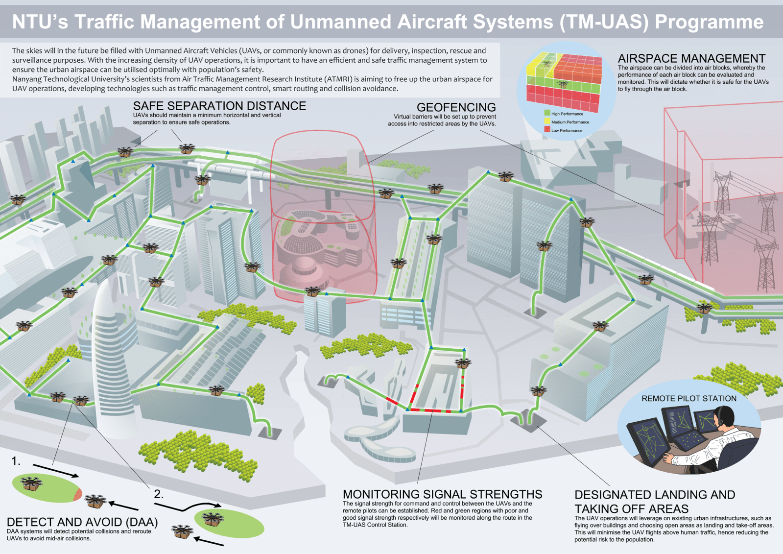
The commercial drone industry in Singapore has seen fast expansion. With limited airspace and a dense population, researchers say that the need for an aerial traffic management system that includes drones has become urgent.
Researchers at Nanyang Technological University, Singapore (NTU Singapore) have taken up the challenge. “The aim is to develop a traffic management system for UAVs consisting designated air-lanes and blocks, similar to how cars on the roads have traffic lights and lanes,” says a University press release.
The plan includes the development of technologies that could be used internationally in drone integration projects: smart and safe routing, detect- and-avoid systems, and traffic management to coordinate air traffic.
Professor Low Kin Huat, an expert in robotics and UAVs from the School of Mechanical and Aerospace Engineering, and ATMRI Senior Research Fellow, Mr Mohamed Faisal Bin Mohamed Salleh are heading the project.
“At NTU, we have already demonstrated viable technologies such as UAV convoys, formation flying and logistics, which will soon become mainstream,” explained Prof Low. “This new traffic management project will test some of the new concepts developed with the aim of achieving safe and efficient drone traffic in our urban airways.”
“The implications of the project will have far reaching consequences, as we are developing ways for seamless travel of unmanned aircrafts for different purposes without compromising safety, which is of paramount importance.”
One possible solution suggested is a system of coordinating drone stations, which could track all of the drones in the air, monitoring their speeds and scheduling the traffic flow. The team will use computer simulations to test the system during this first phase.
“We will also look into proposing safety standards, for instance how high UAVs should fly and how far they should be flying above buildings, taking privacy concerns and laws into consideration, and to suggest recommended actions during contingencies,” said Mr Faisal, who is also Deputy Director at ATMRI.
Researchers may try to utilize existing open fields for take-off and landing, and direct drone traffic over large buildings which could serve as emergency landing sites. The team plans to use existing technologies such as geofencing to avoid traffic in restricted areas, and collision avoidance sensors to reduce the risk of mid-air incidents with other drones.
A video explaining the system can be viewed here as part of the original press release.
Read more at:
Very well done. Absolutely brilliant information. I'm in love with this blog. they always provide such a great information. road kerb ramps
ReplyDelete