suasnews.com
By Press
11 December 2016

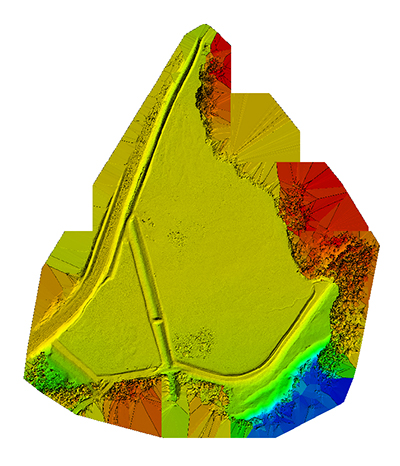
Companies have been mining nickel-copper ores in the northern region of Ontario, Canada since 1901. For this project, the Aeryon SkyRanger sUAS was used to collect imagery from a Tailings Pond and a Slag Heap. This imagery and data would then be used by the mining company to help evaluate the growth of the waste sites and determine next steps in the company’s growth strategy.
The flights were conducted over a day and a half with a mix of sun and cloud, temperatures 50º to 77º F (10º to 25º C), and winds between 9 – 15 mph (15 – 25 kph).
INDUSTRY: Commercial Inspection | REGION: Canada
APPLICATION Tailings Pond
Tailings ponds are created to store waste from the mining extraction process. A tailings pond has a finite lifespan. The objective of this project was to use the aerial data to reflect the pond’s current footprint and compare to previously collected data. The comparison would then help determine how quickly the footprint has changed over time and how close the pond is to reaching its maximum capacity. This information would also be used to plan when to increase the size of the dam or area of the pond.
Slag Heap
A slag heap stores waste from the mining extraction process that cannot be easily separated. The slag heap also has a finite, planned, lifespan. The mine will compare the latest footprint of materials to a previously created orthomosaic map to determine how to optimize the future placement of extracted materials and estimate the rate of expansion since data was last collected. The output of the collected imagery will also be used to predict when longer term expansion (and large expenses) will be needed to further develop the site.
Both waste sites are well into their lifespan, and having the ability to monitor their rate of expansion enable the preparation of large expenditures and additional planning needed for each site. This will allow the mine expand only when necessary to avoid unnecessary expenses. In order to reduce the risk to the natural environment and ensure compliance with regulatory requirements, they must also ensure any expansion occurs before the current site is too full.
REQUIREMENTS
The objective of this project was to demonstrate that the aerial imagery could be collected at a lower cost than a manned helicopter, and that the SkyRanger:
Provides high resolution geo-tagged photos and video
Enables the creation of accurate orthomosaic outputs for further analysis
Does not interfere with normal operations of the mine
Does not negatively affect the local wildlife
This project was a great way for the mining company to trial how best to use UAS technology at the site”, commented Carley Hopkins, Product Manager, Aeryon Labs. “To consistently collect highly accurate data, without disrupting normal activities, will help with planning and overall efficiency of the mine’s operations.”
Read more at:
http://www.suasnews.com/2016/12/using-skyranger-evaluate-lifespan-mining-waste-sites/
No comments:
Post a Comment